TopoQuest Logo
Do you find TopoQuest useful?
Help keep TopoQuest running and adding new maps/features by donating!
Bitcoin:  19c7KJd3qBynnjoSw5npx9KScwjBe4ifkT
Litecoin:  LXs6TkuXGGXo1vDsWCkWVdjQX94eUKd6ui
Home View Maps Find Maps Find Places Resources & Links


Polk City, Iowa Topographic Map

USGS Map Title: Polk City, IA
USGS Map MRC: 41093G6
DRG (GeoTIFF) Download: o41093g6.tif


Neighboring USGS Topographic Map Quads:


  Luther, IA  
41093H7
 

  Slater, IA  
41093H6
 

  Huxley, IA  
41093H5
 

  Granger, IA  
41093G7
 

  Polk City, IA  
41093G6
 

  Elkhart, IA  
41093G5
 

  Grimes, IA  
41093F7
 

  Des Moines NW, IA  
41093F6
 

  Des Moines NE, IA  
41093F5


Map MRC Location:

N42°
W94°
N42°
W93°
H8 H7 H6 H5 H4 H3 H2 H1
G8 G7 G6 G5 G4 G3 G2 G1
F8 F7 F6 F5 F4 F3 F2 F1
E8 E7 E6 E5 E4 E3 E2 E1
D8 D7 D6 D5 D4 D3 D2 D1
C8 C7 C6 C5 C4 C3 C2 C1
B8 B7 B6 B5 B4 B3 B2 B1
A8 A7 A6 A5 A4 A3 A2 A1
N41°
W94°
N41°
W93°

Polk City, IA USGS 1:24K Topographic Map Preview:
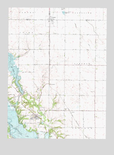
Polk City, IA USGS Topographic Map
Click on map above to begin viewing in our Map Viewer.

This topographic map contains these locations and features:
Feature Name Type Latitude Longitude GNIS ID View Map
Adams School (historical)SchoolN41.7619°W93.6377°463858View Map
All Seasons ParkParkN41.7750°W93.7094°2047588View Map
Alleman CreekStreamN41.8272°W93.6336°465411View Map
Beebe CemeteryCemeteryN41.7695°W93.7096°2047882View Map
Big Creek Barrier DamDamN41.7550°W93.6986°463438View Map
Big Creek LakeLakeN41.8164°W93.7456°454607View Map
Big Creek Pounding AreaLakeN41.7553°W93.7321°463440View Map
Big Creek Terminal DamDamN41.7850°W93.7297°463487View Map
Central SchoolSchoolN41.8208°W93.6336°463948View Map
City of Polk CityCivilN41.7770°W93.7131°2396245View Map
City of SheldahlCivilN41.8643°W93.6966°2395867View Map
CrockerLocaleN41.7747°W93.6699°2047820View Map
CrockerPopulated PlaceN41.7747°W93.6699°455721View Map
Crocker CemeteryCemeteryN41.7784°W93.6779°455722View Map
Crocker Post Office (historical)Post OfficeN41.7747°W93.6699°2047819View Map
Davis Farm CemeteryCemeteryN41.7639°W93.7252°2047881View Map
Evangelical Free ChurchChurchN41.7700°W93.7149°2047585View Map
Franklin School (historical)SchoolN41.7611°W93.6788°463857View Map
Ives School (historical)SchoolN41.8189°W93.6794°463863View Map
L E M Small CemeteryCemeteryN41.7990°W93.7425°2047880View Map
Lincoln CemeteryCemeteryN41.7947°W93.6399°458356View Map
Mayfield School (historical)SchoolN41.8194°W93.7355°463864View Map
Miller ParkParkN41.7714°W93.7183°2047587View Map
North Polk West Elementary SchoolSchoolN41.7777°W93.7258°2047579View Map
PalmerLocaleN41.7917°W93.6397°466122View Map
Palmer Post Office (historical)Post OfficeN41.8083°W93.6397°2047821View Map
Polk CityPopulated PlaceN41.7714°W93.7130°460351View Map
Polk City (historical)LocaleN41.7714°W93.7130°2047580View Map
Polk City CemeteryCemeteryN41.7736°W93.7029°2047883View Map
Polk City City HallBuildingN41.7719°W93.7144°2047584View Map
Polk City Community LibraryBuildingN41.7722°W93.7197°2047581View Map
Polk City JunctionPopulated PlaceN41.8025°W93.6980°464706View Map
Polk City Police DepartmentBuildingN41.7716°W93.7146°2047582View Map
Polk City Post OfficePost OfficeN41.7719°W93.7136°2047578View Map
Polk City Volunteer Fire and Rescue DepartmentBuildingN41.7717°W93.7146°2047583View Map
Saylorville LakeReservoirN41.7553°W93.7321°461452View Map
School Number 4SchoolN41.7950°W93.7169°463952View Map
SheldahlPopulated PlaceN41.8644°W93.6972°461555View Map
SheldahlLocaleN41.8639°W93.6947°2047570View Map
Sheldahl CemeteryCemeteryN41.8504°W93.6929°461556View Map
Sheldahl City HallBuildingN41.8630°W93.6947°2047932View Map
Sheldahl Norwegian Lutheran ChurchChurchN41.8664°W93.6955°2047934View Map
Sheldahl Post OfficePost OfficeN41.8633°W93.6938°2047933View Map
Slater CemeteryCemeteryN41.8712°W93.6745°461668View Map
Township of LincolnCivilN41.8201°W93.6393°468264View Map
Township of MadisonCivilN41.8034°W93.7264°468327View Map
Turkey CreekStreamN41.8283°W93.7352°462363View Map
UlmLocaleN41.8350°W93.6980°466123View Map
Union SchoolSchoolN41.7647°W93.6774°463853View Map
United Methodist ChurchChurchN41.8647°W93.6997°2047559View Map
Unorganized Territory of Saylorville ReservoirCivilN41.7577°W93.7261°468663View Map
Wolf CreekStreamN41.7817°W93.7147°463154View Map

Note: Coordinates in the location and feature list above are referenced to NAD83 datum.


Copyright (C) 2008-2024 Ryan Niemi / Sunset Dynamics ... All Rights Reserved