TopoQuest Logo
Do you find TopoQuest useful?
Help keep TopoQuest running and adding new maps/features by donating!
Bitcoin:  19c7KJd3qBynnjoSw5npx9KScwjBe4ifkT
Litecoin:  LXs6TkuXGGXo1vDsWCkWVdjQX94eUKd6ui
Home View Maps Find Maps Find Places Resources & Links


Grimes, Iowa Topographic Map

USGS Map Title: Grimes, IA
USGS Map MRC: 41093F7
DRG (GeoTIFF) Download: o41093f7.tif


Neighboring USGS Topographic Map Quads:


  Woodward, IA  
41093G8
 

  Granger, IA  
41093G7
 

  Polk City, IA  
41093G6
 

  Dallas Center, IA  
41093F8
 

  Grimes, IA  
41093F7
 

  Des Moines NW, IA  
41093F6
 

  Waukee, IA  
41093E8
 

  Commerce, IA  
41093E7
 

  Des Moines SW, IA  
41093E6


Map MRC Location:

N42°
W94°
N42°
W93°
H8 H7 H6 H5 H4 H3 H2 H1
G8 G7 G6 G5 G4 G3 G2 G1
F8 F7 F6 F5 F4 F3 F2 F1
E8 E7 E6 E5 E4 E3 E2 E1
D8 D7 D6 D5 D4 D3 D2 D1
C8 C7 C6 C5 C4 C3 C2 C1
B8 B7 B6 B5 B4 B3 B2 B1
A8 A7 A6 A5 A4 A3 A2 A1
N41°
W94°
N41°
W93°

Grimes, IA USGS 1:24K Topographic Map Preview:
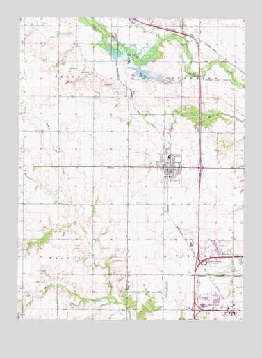
Grimes, IA USGS Topographic Map
Click on map above to begin viewing in our Map Viewer.

This topographic map contains these locations and features:
Feature Name Type Latitude Longitude GNIS ID View Map
Ayers Grove Post Office (historical)Post OfficeN41.6917°W93.7641°2047830View Map
Beaver Creek Golf CourseLocaleN41.7258°W93.7738°2047661View Map
Brenton Brothers FeedlotLocaleN41.7192°W93.8225°2611857View Map
Brenton SloughLakeN41.7253°W93.8027°454817View Map
City of GrimesCivilN41.6775°W93.7946°2394252View Map
City of UrbandaleCivilN41.6390°W93.7814°2397100View Map
Concentra Medical CenterHospitalN41.6364°W93.7724°2047524View Map
Cornerstone Community ChurchChurchN41.6283°W93.7944°2047544View Map
Dallas Center - Grimes High SchoolSchoolN41.6904°W93.8230°2719687View Map
Dallas Center - Grimes Meadows SchoolSchoolN41.6904°W93.8223°2720053View Map
Day Field (historical)AirportN41.6403°W93.8086°466805View Map
Des Moines Christian SchoolSchoolN41.6290°W93.7980°2719998View Map
GrimesLocaleN41.6875°W93.7924°2047651View Map
GrimesPopulated PlaceN41.6883°W93.7911°457148View Map
Grimes City HallBuildingN41.6872°W93.7899°2047647View Map
Grimes City ParkParkN41.6917°W93.7849°2047657View Map
Grimes Family Care CenterHospitalN41.6889°W93.7883°2047652View Map
Grimes Jehovah's Witnesses CongregationChurchN41.6589°W93.7586°2047653View Map
Grimes Post OfficePost OfficeN41.6872°W93.7905°2047649View Map
Grimes Public LibraryBuildingN41.6897°W93.7941°2047646View Map
Grimes SchoolSchoolN41.6847°W93.7916°2047660View Map
Grimes Waste Treatment PlantLocaleN41.7033°W93.7903°2728356View Map
Herrold BridgeBridgeN41.7219°W93.7505°2047904View Map
Hoff Prairie CemeteryCemeteryN41.6880°W93.8224°1996392View Map
Horizon Elementary SchoolSchoolN41.6668°W93.7543°2047642View Map
Ingersoll (historical)Populated PlaceN41.7319°W93.8211°464208View Map
Ingersoll (historical)LocaleN41.7319°W93.8211°1996200View Map
Ingersoll Post Office (historical)Post OfficeN41.7319°W93.8211°1996199View Map
Interchange 126CrossingN41.6294°W93.7769°2047871View Map
Interchange 127CrossingN41.6494°W93.7724°2047870View Map
Iowa OrchardLocaleN41.6447°W93.7536°2740748View Map
Johnston - Grimes Metropolitan Fire Department Station 37BuildingN41.6874°W93.7950°2047648View Map
Johnston Evangelical Free ChurchChurchN41.6736°W93.7516°2047630View Map
Kaplan University - Des Moines CampusSchoolN41.6451°W93.7797°2719805View Map
KDMI-FM (Des Moines)TowerN41.6630°W93.7561°463715View Map
KJJY-FM (Ankeny)TowerN41.6647°W93.7569°467300View Map
Lions ParkParkN41.6936°W93.7849°2047656View Map
Little Walnut CreekStreamN41.6322°W93.8197°458524View Map
Longview Golf CenterLocaleN41.6578°W93.7641°2047645View Map
Maranatha Baptist ChurchChurchN41.6730°W93.7505°2047654View Map
Metro West Learning AcademySchoolN41.6575°W93.7774°2047650View Map
North Ridge Elementary SchoolSchoolN41.7094°W93.7984°2720052View Map
Osprey Post Office (historical)Post OfficeN41.6805°W93.8147°1996202View Map
Park View Village Mobile Home ParkPopulated PlaceN41.6639°W93.7738°2047644View Map
Pleasant Plain School (historical)SchoolN41.6453°W93.7913°463848View Map
RiderPopulated PlaceN41.6442°W93.7697°464717View Map
Rider (historical)LocaleN41.6442°W93.7697°2047832View Map
Rider Post Office (historical)Post OfficeN41.6442°W93.7697°2047831View Map
Robel FieldAirportN41.6575°W93.8211°466804View Map
Saint Peter Lutheran ChurchChurchN41.6805°W93.7944°2047655View Map
Shuler Elementary SchoolSchoolN41.6275°W93.8441°2720073View Map
South Prairie Elementary SchoolSchoolN41.6847°W93.7962°2047659View Map
Sunny Hill CemeteryCemeteryN41.6827°W93.7898°462094View Map
Towner Post Office (historical)Post OfficeN41.7236°W93.7808°2047923View Map
Township of GrantCivilN41.7326°W93.8728°467936View Map
Township of JeffersonCivilN41.7312°W93.7697°468144View Map
Township of WalnutCivilN41.6443°W93.8727°468883View Map
Urbandale Fire Department - Station 42BuildingN41.6328°W93.7820°2047519View Map
Walnut Creek Community ChurchChurchN41.6653°W93.7558°2047629View Map
Walnut Hills Elementary SchoolSchoolN41.6383°W93.8355°2719941View Map
Waterworks ParkParkN41.6903°W93.7961°2047658View Map
Webster Elementary SchoolSchoolN41.6379°W93.7968°2719940View Map

Note: Coordinates in the location and feature list above are referenced to NAD83 datum.


Copyright (C) 2008-2025 Ryan Niemi / Sunset Dynamics ... All Rights Reserved