TopoQuest Logo
Do you find TopoQuest useful?
Help keep TopoQuest running and adding new maps/features by donating!
Bitcoin:  19c7KJd3qBynnjoSw5npx9KScwjBe4ifkT
Litecoin:  LXs6TkuXGGXo1vDsWCkWVdjQX94eUKd6ui
Home View Maps Find Maps Find Places Resources & Links


Pomona, Kansas Topographic Map

USGS Map Title: Pomona, KS
USGS Map MRC: 38095E4
DRG (GeoTIFF) Download: o38095e4.tif


Neighboring USGS Topographic Map Quads:


  Vassar, KS  
38095F5
 

  Ottawa NW, KS  
38095F4
 

  Ottawa North, KS  
38095F3
 

  Quenemo, KS  
38095E5
 

  Pomona, KS  
38095E4
 

  Ottawa South, KS  
38095E3
 

  Waverly, KS  
38095D5
 

  Williamsburg, KS  
38095D4
 

  Richmond, KS  
38095D3


Map MRC Location:

N39°
W96°
N39°
W95°
H8 H7 H6 H5 H4 H3 H2 H1
G8 G7 G6 G5 G4 G3 G2 G1
F8 F7 F6 F5 F4 F3 F2 F1
E8 E7 E6 E5 E4 E3 E2 E1
D8 D7 D6 D5 D4 D3 D2 D1
C8 C7 C6 C5 C4 C3 C2 C1
B8 B7 B6 B5 B4 B3 B2 B1
A8 A7 A6 A5 A4 A3 A2 A1
N38°
W96°
N38°
W95°

Pomona, KS USGS 1:24K Topographic Map Preview:
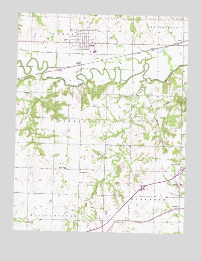
Pomona, KS USGS Topographic Map
Click on map above to begin viewing in our Map Viewer.

This topographic map contains these locations and features:
Feature Name Type Latitude Longitude GNIS ID View Map
Central CemeteryCemeteryN38.5345°W95.4520°2673263View Map
Central ChurchChurchN38.5342°W95.4516°479629View Map
Chanay AirportAirportN38.5350°W95.4496°2651050View Map
Chippewa Ranch Airport (historical)AirportN38.5833°W95.3836°481315View Map
City of PomonaCivilN38.6104°W95.4530°2396249View Map
Coal CreekStreamN38.5864°W95.4016°479633View Map
Greenwood School (historical)SchoolN38.5789°W95.4153°479634View Map
Hard Fish CreekStreamN38.5875°W95.4672°479637View Map
Hickory Hollow Golf ClubLocaleN38.6045°W95.3949°2694569View Map
HomewoodPopulated PlaceN38.5147°W95.3789°479628View Map
Homewood Christian and Community ChurchChurchN38.5136°W95.3784°2688697View Map
Homewood Recreational Vehicle ParkLocaleN38.5397°W95.3775°2692639View Map
Kansas Department of Transportation Franklin County Rest AreaLocaleN38.5265°W95.4054°2692523View Map
Kelsey CreekStreamN38.5975°W95.4061°479330View Map
Lost CreekStreamN38.5939°W95.4778°479329View Map
Middleton School (historical)SchoolN38.5789°W95.4905°479636View Map
Miller DamDamN38.5875°W95.4197°479635View Map
Mount Pleasant CemeteryCemeteryN38.5399°W95.3790°479631View Map
PomonaLocaleN38.5958°W95.4536°484897View Map
PomonaPopulated PlaceN38.6083°W95.4516°479638View Map
Pomona Assembly of God ChurchChurchN38.6105°W95.4510°2690623View Map
Pomona City and Township Fire DepartmentBuildingN38.6082°W95.4518°2111732View Map
Pomona City HallBuildingN38.6076°W95.4538°2693032View Map
Pomona Post OfficePost OfficeN38.6081°W95.4532°2693923View Map
Pomona United Methodist ChurchChurchN38.6101°W95.4517°2689525View Map
Pomona Wastewater Treatment FacilityLocaleN38.6028°W95.4438°2692130View Map
RansomvillePopulated PlaceN38.5064°W95.4258°484896View Map
RichterPopulated PlaceN38.6117°W95.3786°484898View Map
South Illinois School (historical)SchoolN38.5358°W95.4622°479630View Map
Timber Lakes Camp and Retreat CenterLocaleN38.5548°W95.3906°2692917View Map
Timber Lakes Camp and Retreat Center Wastewater Treatment FacilityLocaleN38.5564°W95.3921°2693589View Map
Town and Country Church of the NazareneChurchN38.5030°W95.3802°2688783View Map
Township of GreenwoodCivilN38.5640°W95.4475°479626View Map
Township of HomewoodCivilN38.5065°W95.3879°479641View Map
Township of PomonaCivilN38.6219°W95.4622°479328View Map
West Franklin Learning CenterSchoolN38.5216°W95.4709°2506349View Map
West Franklin Middle / High SchoolSchoolN38.6091°W95.4449°2506574View Map
West Franklin Middle SchoolSchoolN38.6100°W95.4457°2506499View Map
West Franklin Unified School District OfficeSchoolN38.6090°W95.4455°2506350View Map
Whisky CreekStreamN38.5817°W95.4061°479632View Map
Woodlawn CemeteryCemeteryN38.6099°W95.4675°479639View Map

Note: Coordinates in the location and feature list above are referenced to NAD83 datum.


Copyright (C) 2008-2025 Ryan Niemi / Sunset Dynamics ... All Rights Reserved