TopoQuest Logo
Do you find TopoQuest useful?
Help keep TopoQuest running and adding new maps/features by donating!
Bitcoin:  19c7KJd3qBynnjoSw5npx9KScwjBe4ifkT
Litecoin:  LXs6TkuXGGXo1vDsWCkWVdjQX94eUKd6ui
Home View Maps Find Maps Find Places Resources & Links


Ponchatoula NE, Louisiana Topographic Map

USGS Map Title: Ponchatoula NE, LA
USGS Map MRC: 30090D3
DRG (GeoTIFF) Download: o30090d3.tif


Neighboring USGS Topographic Map Quads:


  Hammond, LA  
30090E4
 

  Robert, LA  
30090E3
 

  Martinville, LA  
30090E2
 

  Ponchatoula, LA  
30090D4
 

  Ponchatoula NE, LA  
30090D3
 

  Madisonville, LA  
30090D2
 

  Manchac, LA  
30090C4
 

  Ponchatoula SE, LA  
30090C3
 

  Covington SW, LA  
30090C2


Map MRC Location:

N31°
W91°
N31°
W90°
H8 H7 H6 H5 H4 H3 H2 H1
G8 G7 G6 G5 G4 G3 G2 G1
F8 F7 F6 F5 F4 F3 F2 F1
E8 E7 E6 E5 E4 E3 E2 E1
D8 D7 D6 D5 D4 D3 D2 D1
C8 C7 C6 C5 C4 C3 C2 C1
B8 B7 B6 B5 B4 B3 B2 B1
A8 A7 A6 A5 A4 A3 A2 A1
N30°
W91°
N30°
W90°

Ponchatoula NE, LA USGS 1:24K Topographic Map Preview:
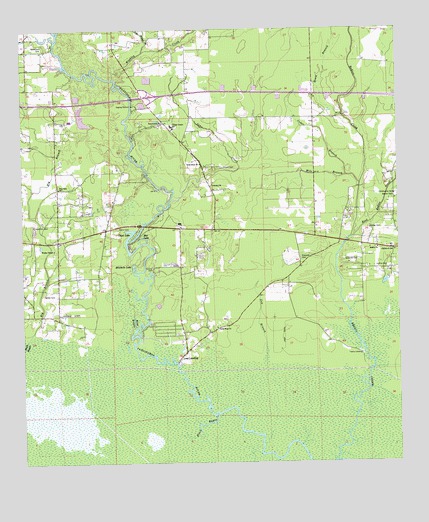
Ponchatoula NE, LA USGS Topographic Map
Click on map above to begin viewing in our Map Viewer.

This topographic map contains these locations and features:
Feature Name Type Latitude Longitude GNIS ID View Map
BedicoPopulated PlaceN30.4363°W90.2517°549618View Map
Bedico ChurchChurchN30.4369°W90.2567°532870View Map
Bedico Church (historical)ChurchN30.4313°W90.2523°549619View Map
Bedico ParkParkN30.4519°W90.2506°532871View Map
Bethel Church of GodChurchN30.4555°W90.3115°553613View Map
Big BranchStreamN30.4107°W90.3737°533048View Map
Black BayouStreamN30.3891°W90.3106°533159View Map
Cedar BranchStreamN30.4580°W90.2670°533833View Map
Champ Cooper Elementary SchoolSchoolN30.4720°W90.3251°1629597View Map
Church of GodChurchN30.4360°W90.2515°549635View Map
Collins CemeteryCemeteryN30.4313°W90.2537°534046View Map
Collins CemeteryCemeteryN30.4313°W90.3320°534047View Map
Cooper CemeteryCemeteryN30.4605°W90.3084°534117View Map
Cow BranchStreamN30.4049°W90.2945°534204View Map
Davis CemeteryCemeteryN30.4430°W90.3434°534405View Map
Dead LakeLakeN30.4413°W90.3387°554201View Map
Dixie BranchStreamN30.4724°W90.2648°534538View Map
Ear LakeLakeN30.4401°W90.3351°554313View Map
East Bedico CreekStreamN30.4399°W90.2659°560682View Map
Edwards CemeteryCemeteryN30.4338°W90.2676°534771View Map
Edwards CemeteryCemeteryN30.4338°W90.2823°534772View Map
Eighth Ward Volunteer Fire Department of Tangipahoa Parish Main StationBuildingN30.4689°W90.3222°2332507View Map
Eighth Ward Volunteer Fire Department of Tangipahoa Parish Station 2BuildingN30.4389°W90.2627°2691804View Map
Good Hope ChurchChurchN30.4144°W90.3109°535269View Map
Good Hope ChurchChurchN30.4613°W90.3159°554544View Map
Holden BranchStreamN30.4996°W90.3165°535710View Map
Howe School (historical)SchoolN30.4280°W90.3634°549685View Map
Howes CemeteryCemeteryN30.4238°W90.3681°535840View Map
Interchange 47CrossingN30.4807°W90.3334°541453View Map
Katie (historical)Populated PlaceN30.4316°W90.2829°549692View Map
Lees LandingPopulated PlaceN30.4044°W90.3237°555013View Map
Lees Landing United Methodist ChurchChurchN30.4110°W90.3212°549697View Map
Mile BranchStreamN30.4555°W90.2626°537080View Map
Mitchell Lake Gas FieldOilfieldN30.4391°W90.3459°549715View Map
Mitchells LakeLakeN30.4321°W90.3384°555342View Map
New Hope Church (historical)ChurchN30.4427°W90.3023°549725View Map
P-Kaw-Shun CreekStreamN30.4999°W90.2870°555580View Map
Pentecostal ChurchChurchN30.4821°W90.3284°1958834View Map
Pine Dale ChurchChurchN30.4544°W90.3626°555651View Map
Pole Bridge BranchStreamN30.4935°W90.3343°532063View Map
Rice BayouStreamN30.4135°W90.3379°538578View Map
Robertson CemeteryCemeteryN30.4960°W90.3676°538643View Map
Sand Hill CemeteryCemeteryN30.4438°W90.3712°539134View Map
Sheridan's StripAirportN30.4718°W90.3660°2770269View Map
Sims CreekStreamN30.4516°W90.3254°558318View Map
Stango CemeteryCemeteryN30.4427°W90.2598°539622View Map
Stevens StripAirportN30.4199°W90.3625°2676763View Map
Wallace LandingPopulated PlaceN30.4060°W90.2626°543731View Map
Ward EightCivilN30.4630°W90.2918°545211View Map
Washley CreekStreamN30.4860°W90.3443°558342View Map
Wesley Chapel United Methodist ChurchChurchN30.4369°W90.3645°556384View Map

Note: Coordinates in the location and feature list above are referenced to NAD83 datum.


Copyright (C) 2008-2025 Ryan Niemi / Sunset Dynamics ... All Rights Reserved