TopoQuest Logo
Do you find TopoQuest useful?
Help keep TopoQuest running and adding new maps/features by donating!
Bitcoin:  19c7KJd3qBynnjoSw5npx9KScwjBe4ifkT
Litecoin:  LXs6TkuXGGXo1vDsWCkWVdjQX94eUKd6ui
Home View Maps Find Maps Find Places Resources & Links


Robert, Louisiana Topographic Map

USGS Map Title: Robert, LA
USGS Map MRC: 30090E3
DRG (GeoTIFF) Download: o30090e3.tif


Neighboring USGS Topographic Map Quads:


  Loranger, LA  
30090F4
 

  Husser, LA  
30090F3
 

  Folsom, LA  
30090F2
 

  Hammond, LA  
30090E4
 

  Robert, LA  
30090E3
 

  Martinville, LA  
30090E2
 

  Ponchatoula, LA  
30090D4
 

  Ponchatoula NE, LA  
30090D3
 

  Madisonville, LA  
30090D2


Map MRC Location:

N31°
W91°
N31°
W90°
H8 H7 H6 H5 H4 H3 H2 H1
G8 G7 G6 G5 G4 G3 G2 G1
F8 F7 F6 F5 F4 F3 F2 F1
E8 E7 E6 E5 E4 E3 E2 E1
D8 D7 D6 D5 D4 D3 D2 D1
C8 C7 C6 C5 C4 C3 C2 C1
B8 B7 B6 B5 B4 B3 B2 B1
A8 A7 A6 A5 A4 A3 A2 A1
N30°
W91°
N30°
W90°

Robert, LA USGS 1:24K Topographic Map Preview:
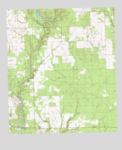
Robert, LA USGS Topographic Map
Click on map above to begin viewing in our Map Viewer.

This topographic map contains these locations and features:
Feature Name Type Latitude Longitude GNIS ID View Map
Alligator BranchStreamN30.6230°W90.2590°532133View Map
Baggage BranchStreamN30.5513°W90.2962°559809View Map
Bailey BranchStreamN30.6085°W90.3323°532277View Map
Bankston CemeteryCemeteryN30.5207°W90.3718°532305View Map
Bible Covenant ChurchChurchN30.5038°W90.2987°533007View Map
Camp ChemeketeLocaleN30.5441°W90.3604°549628View Map
Chappepeela CreekStreamN30.5363°W90.3629°558193View Map
Chappepeela LakeLakeN30.6201°W90.3384°553951View Map
Chappepeela Lake DamDamN30.6210°W90.3387°556863View Map
Chemekete Recreation ClubLocaleN30.5316°W90.3570°549630View Map
Cranky CornerPopulated PlaceN30.6207°W90.2615°541079View Map
Creekside Baptist ChurchChurchN30.5643°W90.3408°2601551View Map
First Missionary ChurchChurchN30.5060°W90.3476°534955View Map
Fox BranchStreamN30.5485°W90.3029°535073View Map
Garahy CemeteryCemeteryN30.5532°W90.3517°535169View Map
Glenwood Baptist Youth CampLocaleN30.6216°W90.2751°549662View Map
Henen CemeteryCemeteryN30.6113°W90.3304°535627View Map
Husser Volunteer Fire Department Station 2BuildingN30.5736°W90.3323°2691803View Map
Joiner CemeteryCemeteryN30.6005°W90.3265°536091View Map
Joiner CemeteryCemeteryN30.6135°W90.3312°536092View Map
Koenig AirparkAirportN30.5969°W90.3164°2676804View Map
Little Chappepeela CreekStreamN30.6207°W90.3459°555058View Map
Little CreekStreamN30.5521°W90.2984°536525View Map
LorrainePopulated PlaceN30.5060°W90.2784°541131View Map
Lorraine Lookout TowerLocaleN30.5060°W90.2773°549705View Map
Louisiana State University Hammond Experimental StationLocaleN30.5032°W90.3743°549706View Map
Mirror LakeLakeN30.6141°W90.3255°555334View Map
Mirror Lake DamDamN30.6146°W90.3254°556864View Map
Mount Zion ChurchChurchN30.6227°W90.2734°537432View Map
Oak Grove ChurchChurchN30.6063°W90.3379°537774View Map
Pollard BranchStreamN30.5488°W90.3018°538321View Map
Regina Coeli Child Development CenterSchoolN30.5054°W90.3500°2600254View Map
Reid CemeteryCemeteryN30.5652°W90.3434°538562View Map
River Oaks (historical)LocaleN30.5085°W90.3718°549736View Map
RobertPopulated PlaceN30.5063°W90.3409°538632View Map
Robert Church of GodChurchN30.5055°W90.3409°549737View Map
Robert Post OfficePost OfficeN30.5012°W90.3445°2600357View Map
Robertson CemeteryCemeteryN30.5291°W90.3567°538644View Map
Robertson CemeteryCemeteryN30.5407°W90.3609°538645View Map
Shaw Crop Service AirportAirportN30.5780°W90.3130°1632737View Map
Skulls CreekStreamN30.5080°W90.3612°556060View Map
UneedusPopulated PlaceN30.6174°W90.2612°543746View Map
White Oak BranchStreamN30.5560°W90.3090°540367View Map
Wilson - Willie CemeteryCemeteryN30.5832°W90.2670°540489View Map
Zemurray Airport (historical)AirportN30.6227°W90.3323°1632738View Map
Zemurray LodgeLocaleN30.6160°W90.3309°556491View Map

Note: Coordinates in the location and feature list above are referenced to NAD83 datum.


Copyright (C) 2008-2024 Ryan Niemi / Sunset Dynamics ... All Rights Reserved