TopoQuest Logo
Do you find TopoQuest useful?
Help keep TopoQuest running and adding new maps/features by donating!
Bitcoin:  19c7KJd3qBynnjoSw5npx9KScwjBe4ifkT
Litecoin:  LXs6TkuXGGXo1vDsWCkWVdjQX94eUKd6ui
Home View Maps Find Maps Find Places Resources & Links


Porcupine Ridge, Montana Topographic Map

USGS Map Title: Porcupine Ridge, MT
USGS Map MRC: 48113H8
DRG (GeoTIFF) Download: o48113h8.tif


Neighboring USGS Topographic Map Quads:


  Mount Carter, MT  
48114H1
 

  Porcupine Ridge, MT  
48113H8
 

  Mount Cleveland, MT  
48113H7
 

  Vulture Peak, MT  
48114G1
 

  Mount Geduhn, MT  
48113G8
 

  Ahern Pass, MT  
48113G7


Map MRC Location:

N49°
W114°
N49°
W113°
H8 H7 H6 H5 H4 H3 H2 H1
G8 G7 G6 G5 G4 G3 G2 G1
F8 F7 F6 F5 F4 F3 F2 F1
E8 E7 E6 E5 E4 E3 E2 E1
D8 D7 D6 D5 D4 D3 D2 D1
C8 C7 C6 C5 C4 C3 C2 C1
B8 B7 B6 B5 B4 B3 B2 B1
A8 A7 A6 A5 A4 A3 A2 A1
N48°
W114°
N48°
W113°

Porcupine Ridge, MT USGS 1:24K Topographic Map Preview:
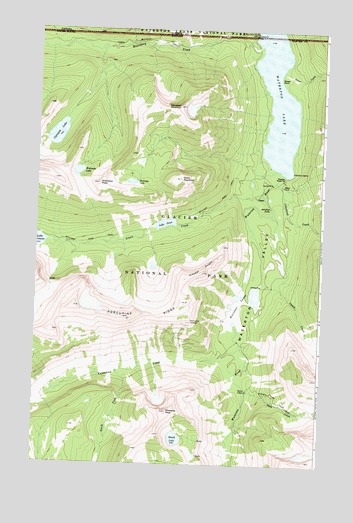
Porcupine Ridge, MT USGS Topographic Map
Click on map above to begin viewing in our Map Viewer.

This topographic map contains these locations and features:
Feature Name Type Latitude Longitude GNIS ID View Map
Bench LakeLakeN48.8823°W113.9376°768698View Map
Boundary CreekStreamN48.9964°W113.9046°769129View Map
Camp CreekStreamN48.9275°W113.9010°769541View Map
Campbell MountainSummitN48.9778°W113.9385°769553View Map
Carcajou LakeLakeN48.9698°W113.9914°769596View Map
Citadel PeaksRidgeN48.9283°W113.9347°769885View Map
Cleveland CreekStreamN48.9564°W113.8962°769930View Map
Kootenai LakesLakeN48.9212°W113.9031°773123View Map
Kootenai PeakSummitN48.8901°W113.9420°773125View Map
Lake JanetLakeN48.9442°W113.9442°772793View Map
North Boundary TrailTrailN48.9966°W113.9637°774677View Map
Olson CreekStreamN48.9536°W113.9018°774963View Map
Olson MountainSummitN48.9571°W113.9374°774966View Map
Pass CreekStreamN48.8969°W113.9082°775103View Map
Porcupine LookoutLocaleN48.9161°W113.9323°775376View Map
Porcupine RidgeRidgeN48.9200°W113.9832°775378View Map
Rainbow FallsFallsN48.9492°W113.8984°775533View Map
Shaheeya LakeLakeN48.9561°W113.9591°776391View Map
Shaheeya PeakSummitN48.9555°W113.9734°776392View Map
South Fork Valentine CreekStreamN48.9011°W113.9637°776884View Map
Street CreekStreamN48.9889°W113.8937°777261View Map
Street PointCapeN48.9861°W113.8946°777262View Map
Upper Waterton LakeLakeN48.9789°W113.8957°778140View Map
Valentine CreekStreamN48.9083°W113.9098°777969View Map
Wahseeja LakeLakeN48.9590°W113.9824°778073View Map
Waterton Ranger StationLocaleN48.9580°W113.8921°778141View Map
Waterton ValleyValleyN48.9592°W113.8956°778143View Map

Note: Coordinates in the location and feature list above are referenced to NAD83 datum.


Copyright (C) 2008-2024 Ryan Niemi / Sunset Dynamics ... All Rights Reserved