TopoQuest Logo
Do you find TopoQuest useful?
Help keep TopoQuest running and adding new maps/features by donating!
Bitcoin:  19c7KJd3qBynnjoSw5npx9KScwjBe4ifkT
Litecoin:  LXs6TkuXGGXo1vDsWCkWVdjQX94eUKd6ui
Home View Maps Find Maps Find Places Resources & Links


Mount Cleveland, Montana Topographic Map

USGS Map Title: Mount Cleveland, MT
USGS Map MRC: 48113H7
DRG (GeoTIFF) Download: o48113h7.tif


Neighboring USGS Topographic Map Quads:


  Porcupine Ridge, MT  
48113H8
 

  Mount Cleveland, MT  
48113H7
 

  Gable Mountain, MT  
48113H6
 

  Mount Geduhn, MT  
48113G8
 

  Ahern Pass, MT  
48113G7
 

  Many Glacier, MT  
48113G6


Map MRC Location:

N49°
W114°
N49°
W113°
H8 H7 H6 H5 H4 H3 H2 H1
G8 G7 G6 G5 G4 G3 G2 G1
F8 F7 F6 F5 F4 F3 F2 F1
E8 E7 E6 E5 E4 E3 E2 E1
D8 D7 D6 D5 D4 D3 D2 D1
C8 C7 C6 C5 C4 C3 C2 C1
B8 B7 B6 B5 B4 B3 B2 B1
A8 A7 A6 A5 A4 A3 A2 A1
N48°
W114°
N48°
W113°

Mount Cleveland, MT USGS 1:24K Topographic Map Preview:
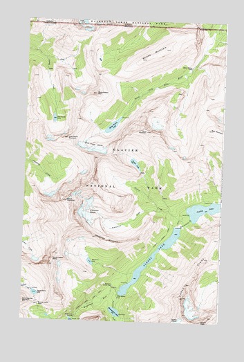
Mount Cleveland, MT USGS Topographic Map
Click on map above to begin viewing in our Map Viewer.

This topographic map contains these locations and features:
Feature Name Type Latitude Longitude GNIS ID View Map
Atsina LakeLakeN48.8752°W113.8433°768392View Map
Bear MountainSummitN48.9551°W113.7576°768602View Map
Cosley LakeLakeN48.9223°W113.7602°770127View Map
Cosley RidgeRidgeN48.8783°W113.7733°770129View Map
Glenns LakeLakeN48.9008°W113.7937°771806View Map
Goat Haunt LakeLakeN48.9588°W113.8572°771812View Map
Goat Haunt MountainSummitN48.9507°W113.8488°771813View Map
Kaina CreekStreamN48.9172°W113.7707°772929View Map
Kaina LakeLakeN48.9407°W113.8056°772931View Map
Kaina MountainSummitN48.9540°W113.7988°772930View Map
Lewis RangeRangeN48.8833°W113.8510°767937View Map
Miche Wabun FallsFallsN48.9809°W113.7714°774126View Map
Miche Wabun GlacierGlacierN48.9456°W113.8294°774127View Map
Miche Wabun LakeLakeN48.9560°W113.8208°774128View Map
Miche Wabun PeakSummitN48.9697°W113.8311°774129View Map
Mokowanis CascadeFallsN48.8765°W113.8413°774326View Map
Mokowanis LakeLakeN48.8790°W113.8161°774327View Map
Mokowanis Shelter CabinLocaleN48.8897°W113.8187°774329View Map
Mount ClevelandSummitN48.9245°W113.8480°769931View Map
Pyramid CreekStreamN48.8866°W113.8135°775498View Map
Sarcee MountainSummitN48.9884°W113.7877°776222View Map
Stoney Indian LakeLakeN48.8862°W113.8667°777237View Map
Stoney Indian PassGapN48.8816°W113.8648°777238View Map
Stoney Indian Pass TrailTrailN48.8783°W113.8598°777239View Map
Stoney Indian PeaksSummitN48.8979°W113.8581°777240View Map
Wahcheechee MountainSummitN48.8829°W113.8743°778072View Map
White Quiver FallsFallsN48.8859°W113.8148°778397View Map
Whitecrow CreekStreamN48.9222°W113.7912°778412View Map
Whitecrow GlacierGlacierN48.9180°W113.8362°778413View Map
Whitecrow LakeLakeN48.8996°W113.8323°778414View Map
Whitecrow MountainSummitN48.9101°W113.8301°778415View Map
Wilson RangeRangeN48.9962°W113.8450°807073View Map

Note: Coordinates in the location and feature list above are referenced to NAD83 datum.


Copyright (C) 2008-2024 Ryan Niemi / Sunset Dynamics ... All Rights Reserved