TopoQuest Logo
Do you find TopoQuest useful?
Help keep TopoQuest running and adding new maps/features by donating!
Bitcoin:  19c7KJd3qBynnjoSw5npx9KScwjBe4ifkT
Litecoin:  LXs6TkuXGGXo1vDsWCkWVdjQX94eUKd6ui
Home View Maps Find Maps Find Places Resources & Links


Port Ingleside, Texas Topographic Map

USGS Map Title: Port Ingleside, TX
USGS Map MRC: 27097G2
DRG (GeoTIFF) Download: o27097g2.tif


Neighboring USGS Topographic Map Quads:


  Gregory, TX  
27097H3
 

  Aransas Pass, TX  
27097H2
 

  Estes, TX  
27097H1
 

  Portland, TX  
27097G3
 

  Port Ingleside, TX  
27097G2
 

  Port Aransas, TX  
27097G1
 

  Oso Creek NE, TX  
27097F3
 

  Crane Islands NW, TX  
27097F2


Map MRC Location:

N28°
W98°
N28°
W97°
H8 H7 H6 H5 H4 H3 H2 H1
G8 G7 G6 G5 G4 G3 G2 G1
F8 F7 F6 F5 F4 F3 F2 F1
E8 E7 E6 E5 E4 E3 E2 E1
D8 D7 D6 D5 D4 D3 D2 D1
C8 C7 C6 C5 C4 C3 C2 C1
B8 B7 B6 B5 B4 B3 B2 B1
A8 A7 A6 A5 A4 A3 A2 A1
N27°
W98°
N27°
W97°

Port Ingleside, TX USGS 1:24K Topographic Map Preview:
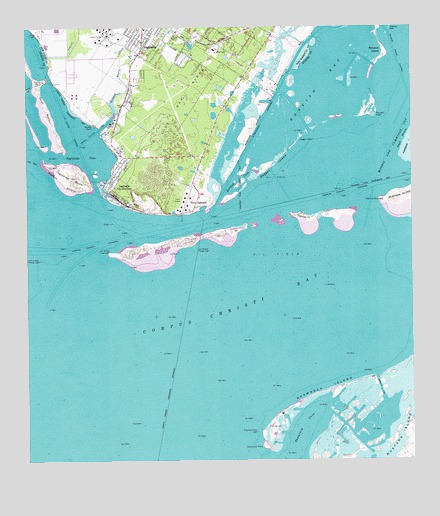
Port Ingleside, TX USGS Topographic Map
Click on map above to begin viewing in our Map Viewer.

This topographic map contains these locations and features:
Feature Name Type Latitude Longitude GNIS ID View Map
Arco Ingleside Shorebase HeliportAirportN27.8481°W97.2230°1386936View Map
Atlantic ChannelChannelN27.8211°W97.1389°1377228View Map
Atlantic CutChannelN27.7709°W97.1355°1329824View Map
Bahia MarinaLocaleN27.8306°W97.2255°2030491View Map
Caruthers Cove ColoniaPopulated PlaceN27.8442°W97.2222°2011352View Map
City of InglesideCivilN27.8701°W97.2077°2410104View Map
City of Ingleside on the BayCivilN27.8302°W97.2212°2410105View Map
Cooks IslandIslandN27.8325°W97.2280°1377231View Map
Corpus Christi ChannelChannelN27.8131°W97.2258°1333384View Map
Cut B East Lead LightLocaleN27.8109°W97.2267°1333839View Map
Cut B East Range LightLocaleN27.8111°W97.1944°1333840View Map
Dagger IslandIslandN27.8350°W97.1711°1333864View Map
Dagger PointCapeN27.8436°W97.1605°1333866View Map
Donnel PointCapeN27.8614°W97.2419°1377702View Map
Elizabeth Cook Primary SchoolSchoolN27.8712°W97.1971°2434305View Map
Garza-4th-6th Streets ColoniaPopulated PlaceN27.8634°W97.1933°2011314View Map
Gilbert J Mircovich Elementary SchoolSchoolN27.8696°W97.2046°2434551View Map
Green Shack CoveSlopeN27.7636°W97.1439°1377233View Map
Harbor City (historical)Populated PlaceN27.8239°W97.1955°1829127View Map
Indian Trails Lane ColoniaPopulated PlaceN27.8742°W97.1872°2011318View Map
Ingleside CoveBayN27.8386°W97.2303°1338471View Map
Ingleside Offshore Services HeliportAirportN27.8450°W97.2239°1386938View Map
Ingleside on the Bay City HallBuildingN27.8298°W97.2219°2753469View Map
Ingleside on the Bay Historical Society MuseumBuildingN27.8581°W97.2067°2014438View Map
Ingleside on the Bay Volunteer Fire DepartmentBuildingN27.8298°W97.2219°2334638View Map
Ingleside On-the-BayPopulated PlaceN27.8295°W97.2233°1388187View Map
Ingleside PointCapeN27.8322°W97.2350°1338472View Map
Ingleside Police DepartmentBuildingN27.8679°W97.2148°2335021View Map
Ingleside Volunteer Fire DepartmentBuildingN27.8680°W97.2150°2334253View Map
Jewell Fulton CanalCanalN27.8450°W97.2275°1338731View Map
Kinney BayouStreamN27.8459°W97.2261°1339151View Map
La Quinta ChannelChannelN27.8456°W97.2353°1339394View Map
Little Shamrock CoveBayN27.7553°W97.1705°1377237View Map
McGloins BluffCliffN27.8247°W97.2189°1381017View Map
Naval Station InglesideMilitaryN27.8297°W97.2021°2511934View Map
Naval Station Ingleside Fire DepartmentBuildingN27.8276°W97.2009°2334640View Map
Navsta Ingleside HeliportAirportN27.8356°W97.2036°1386940View Map
Oak Ridge HeliportAirportN27.8614°W97.1989°1386937View Map
Old Ingleside ColoniaPopulated PlaceN27.8403°W97.2203°2011290View Map
Pelican IslandIslandN27.8211°W97.1544°1343808View Map
Pink Shack CoveBayN27.7578°W97.1500°1381045View Map
Point of MustangCapeN27.8253°W97.1342°1344300View Map
Port Aransas DivisionCivilN27.7623°W97.1937°1939100View Map
Port InglesidePopulated PlaceN27.8236°W97.1953°1378901View Map
Ransom IslandIslandN27.8686°W97.1339°1375634View Map
Ransom Island ChannelChannelN27.8656°W97.1294°1375635View Map
Ransom PointCapeN27.8500°W97.1369°1344802View Map
Redfish CoveBayN27.8314°W97.1811°1344978View Map
Shamrock CoveBayN27.7561°W97.1622°1346964View Map
Shamrock IslandIslandN27.7661°W97.1630°1346965View Map
Shamrock PointCapeN27.7542°W97.1736°1346966View Map
Shamrock Point LightLocaleN27.7586°W97.1761°1346967View Map
Sinclair CutChannelN27.7631°W97.1397°1381046View Map
Sting Ray HoleBasinN27.8195°W97.1355°1377243View Map
Welder PointCapeN27.8472°W97.2278°1349629View Map
Wendy Acres ColoniaPopulated PlaceN27.8742°W97.2014°2011253View Map

Note: Coordinates in the location and feature list above are referenced to NAD83 datum.


Copyright (C) 2008-2024 Ryan Niemi / Sunset Dynamics ... All Rights Reserved