TopoQuest Logo
Do you find TopoQuest useful?
Help keep TopoQuest running and adding new maps/features by donating!
Bitcoin:  19c7KJd3qBynnjoSw5npx9KScwjBe4ifkT
Litecoin:  LXs6TkuXGGXo1vDsWCkWVdjQX94eUKd6ui
Home View Maps Find Maps Find Places Resources & Links


Bicknell, Utah Topographic Map

USGS Map Title: Bicknell, UT
USGS Map MRC: 38111C5
DRG (GeoTIFF) Download: o38111c5.tif


Neighboring USGS Topographic Map Quads:


  Loa, UT  
38111D6
 

  Lyman, UT  
38111D5
 

  Flat Top, UT  
38111D4
 

  Moroni Peak, UT  
38111C6
 

  Bicknell, UT  
38111C5
 

  Torrey, UT  
38111C4
 

  Smooth Knoll, UT  
38111B6
 

  Government Point, UT  
38111B5
 

  Blind Lake, UT  
38111B4


Map MRC Location:

N39°
W112°
N39°
W111°
H8 H7 H6 H5 H4 H3 H2 H1
G8 G7 G6 G5 G4 G3 G2 G1
F8 F7 F6 F5 F4 F3 F2 F1
E8 E7 E6 E5 E4 E3 E2 E1
D8 D7 D6 D5 D4 D3 D2 D1
C8 C7 C6 C5 C4 C3 C2 C1
B8 B7 B6 B5 B4 B3 B2 B1
A8 A7 A6 A5 A4 A3 A2 A1
N38°
W112°
N38°
W111°

Bicknell, UT USGS 1:24K Topographic Map Preview:
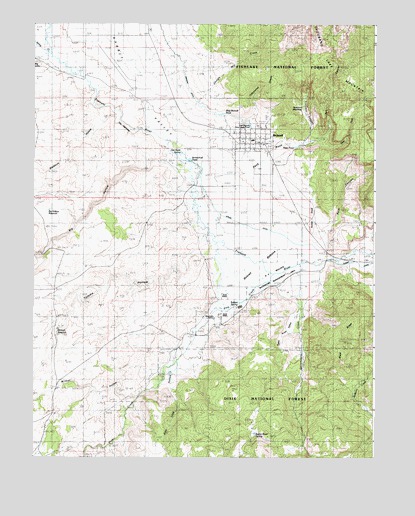
Bicknell, UT USGS Topographic Map
Click on map above to begin viewing in our Map Viewer.

This topographic map contains these locations and features:
Feature Name Type Latitude Longitude GNIS ID View Map
Aquarius Mobile and RV CampgroundLocaleN38.3419°W111.5188°1448082View Map
BicknellPopulated PlaceN38.3408°W111.5441°1438623View Map
Bicknell BottomsFlatN38.3058°W111.5441°1438624View Map
Bicknell CemeteryCemeteryN38.3253°W111.5371°1438625View Map
Bicknell Fire DepartmentBuildingN38.3421°W111.5527°2627441View Map
Bicknell Post OfficePost OfficeN38.3404°W111.5431°2769043View Map
Bicknell Post OfficePost OfficeN38.3405°W111.5616°1455184View Map
Bicknell ReservoirReservoirN38.2869°W111.6162°1448129View Map
Big HollowValleyN38.3341°W111.5821°1438683View Map
Big Hollow ReservoirReservoirN38.3212°W111.6197°1448132View Map
Black RidgeRidgeN38.2836°W111.5107°1438870View Map
Blackburn HollowValleyN38.3486°W111.5952°1438885View Map
Brinkerhoff PondReservoirN38.3358°W111.5681°1448189View Map
Bullard SpringSpringN38.2940°W111.5503°1448206View Map
Cottonwood CanyonValleyN38.3475°W111.5463°1448305View Map
Crescent CanyonValleyN38.3411°W111.5271°1440147View Map
Dab Keele SpringSpringN38.3382°W111.5714°1448319View Map
East Bicknell Sand Wash PondReservoirN38.3454°W111.5460°1448364View Map
East Fork Red CanyonValleyN38.3411°W111.5207°1440804View Map
Government CreekStreamN38.3058°W111.5277°1441395View Map
Hemlock MeadowFlatN38.3511°W111.5282°1441696View Map
KE Bullock Waterfowl Management AreaParkN38.2966°W111.5452°1448531View Map
Lee HollowValleyN38.3311°W111.5655°1455367View Map
Loa DivisionCivilN38.3069°W111.5747°1939385View Map
Petes PondReservoirN38.3395°W111.5296°1436118View Map
Pine CreekStreamN38.3030°W111.5346°1431254View Map
Pine Creek SpringSpringN38.2903°W111.5592°1448833View Map
Pole CanyonValleyN38.2691°W111.6024°1444523View Map
Rabbit Brush HollowValleyN38.3014°W111.5374°1448892View Map
Rabbit Brush SpringSpringN38.2564°W111.5437°1448893View Map
Rabbit ValleyValleyN38.3578°W111.5991°1444704View Map
Red CanyonValleyN38.3397°W111.5305°1440724View Map
Rock CanyonValleyN38.3155°W111.5185°1445031View Map
Saddle KnollSummitN38.3211°W111.5235°1445224View Map
Sage Flat DrawValleyN38.3075°W111.6221°1445242View Map
Sam Legg HollowValleyN38.2708°W111.5741°1445292View Map
Sand WashValleyN38.3311°W111.5593°1455500View Map
Shingle Mill CreekStreamN38.3419°W111.5738°1445538View Map
Spring CreekStreamN38.3658°W111.6191°1446012View Map
Spring DitchCanalN38.3178°W111.5496°1446028View Map
Sunglow Forest CampLocaleN38.3436°W111.5160°1446252View Map
The Church of Jesus Christ of Latter Day SaintsChurchN38.3416°W111.5466°1449643View Map
The NarrowsGapN38.3483°W111.5943°1446472View Map
Tommy HollowValleyN38.3105°W111.5632°1446641View Map
Town of BicknellCivilN38.3407°W111.5442°2411685View Map
Trail CreekStreamN38.3680°W111.5918°1446674View Map
Tub DitchCanalN38.3261°W111.5566°1446750View Map
Upper Corral CanyonValleyN38.3736°W111.5841°1449131View Map
Wayne County Ambulance - BicknellBuildingN38.3421°W111.5528°2665419View Map
Wayne High SchoolSchoolN38.3438°W111.5520°1449166View Map
Wayne Middle SchoolSchoolN38.3434°W111.5519°1449167View Map
Wayne Wonderland AirportAirportN38.3574°W111.5892°1447596View Map
West Bicknell PondReservoirN38.3489°W111.5567°1449170View Map
Wildcat HollowValleyN38.2911°W111.6127°1447359View Map

Note: Coordinates in the location and feature list above are referenced to NAD83 datum.


Copyright (C) 2008-2024 Ryan Niemi / Sunset Dynamics ... All Rights Reserved