TopoQuest Logo
Do you find TopoQuest useful?
Help keep TopoQuest running and adding new maps/features by donating!
Bitcoin:  19c7KJd3qBynnjoSw5npx9KScwjBe4ifkT
Litecoin:  LXs6TkuXGGXo1vDsWCkWVdjQX94eUKd6ui
Home View Maps Find Maps Find Places Resources & Links


Powell, Ohio Topographic Map

USGS Map Title: Powell, OH
USGS Map MRC: 40083B1
DRG (GeoTIFF) Download: o40083b1.tif


Neighboring USGS Topographic Map Quads:


  Ostrander, OH  
40083C2
 

  Delaware, OH  
40083C1
 

  Kilbourne, OH  
40082C8
 

  Shawnee Hills, OH  
40083B2
 

  Powell, OH  
40083B1
 

  Galena, OH  
40082B8
 

  Hilliard, OH  
40083A2
 

  Northwest Columbus, OH  
40083A1
 

  Northeast Columbus, OH  
40082A8


Map MRC Location:

N41°
W84°
N41°
W83°
H8 H7 H6 H5 H4 H3 H2 H1
G8 G7 G6 G5 G4 G3 G2 G1
F8 F7 F6 F5 F4 F3 F2 F1
E8 E7 E6 E5 E4 E3 E2 E1
D8 D7 D6 D5 D4 D3 D2 D1
C8 C7 C6 C5 C4 C3 C2 C1
B8 B7 B6 B5 B4 B3 B2 B1
A8 A7 A6 A5 A4 A3 A2 A1
N40°
W84°
N40°
W83°

Powell, OH USGS 1:24K Topographic Map Preview:
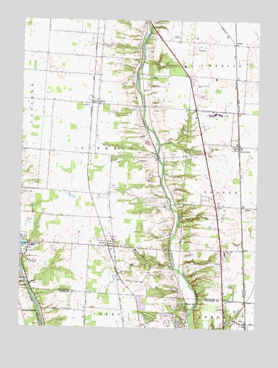
Powell, OH USGS Topographic Map
Click on map above to begin viewing in our Map Viewer.

This topographic map contains these locations and features:
Feature Name Type Latitude Longitude GNIS ID View Map
Bartholomew RunStreamN40.1495°W83.0432°1037655View Map
Big Meadows Picnic AreaLocaleN40.1542°W83.0416°1955583View Map
Big RunStreamN40.1994°W83.0519°2649140View Map
Bluff RunStreamN40.2151°W83.0602°1068374View Map
Braumiller WoodsPopulated PlaceN40.2461°W83.0380°2771845View Map
BridlespurPopulated PlaceN40.1919°W83.0699°2771846View Map
Camp LazarusLocaleN40.2328°W83.0499°1038715View Map
Cheshire CrossingPopulated PlaceN40.2449°W83.0478°2771849View Map
City of PowellCivilN40.1679°W83.0799°2396264View Map
Cole CemeteryCemeteryN40.2245°W83.0732°1039249View Map
Columbus ZooParkN40.1559°W83.1224°1060990View Map
Deep RunStreamN40.1681°W83.0413°1039643View Map
Deer RunStreamN40.1431°W83.1213°1065973View Map
Delaware Country ClubLocaleN40.2487°W83.0513°1064270View Map
Dornoch EstatesPopulated PlaceN40.2500°W83.0470°2771850View Map
Double Duros Country ClubLocaleN40.1517°W83.1207°1080081View Map
Edward F Hutchins Nature PreserveParkN40.1362°W83.0299°1955648View Map
Estates At BraumillerPopulated PlaceN40.2478°W83.0368°2771851View Map
Fairview Memorial ParkCemeteryN40.2237°W83.0344°1040362View Map
FlintPopulated PlaceN40.1273°W83.0057°1040526View Map
Flint CemeteryCemeteryN40.1320°W83.0094°1040527View Map
Flint Post Office (historical)Post OfficeN40.1265°W83.0055°1985732View Map
Friends ChurchChurchN40.1748°W83.0205°1040690View Map
Glen OakPopulated PlaceN40.1787°W83.0014°2771244View Map
GlenrossPopulated PlaceN40.2450°W83.0292°2771852View Map
Green Meadows Corporate CenterLocaleN40.1556°W83.0166°1064271View Map
GregoryPopulated PlaceN40.2403°W83.0130°1062795View Map
Gregory Post Office (historical)Post OfficeN40.2403°W83.0130°1983791View Map
Hidden SpringsPopulated PlaceN40.1719°W83.0119°2771246View Map
High Banks Metropolitan ParkParkN40.1278°W83.0335°1059962View Map
Huffman Industrial ParkLocaleN40.1623°W83.0749°1064267View Map
Hyatt United Methodist ChurchChurchN40.2162°W83.0852°1064269View Map
HyattsPopulated PlaceN40.2167°W83.0852°1085467View Map
Jacks RunStreamN40.1877°W83.0502°1068391View Map
Leatherlips CemeteryCemeteryN40.1398°W83.1181°1961094View Map
Lewis CenterPopulated PlaceN40.1984°W83.0102°1057794View Map
Lewis Center Post OfficePost OfficeN40.1987°W83.0096°1984015View Map
Liberty CemeteryCemeteryN40.1948°W83.0540°1806221View Map
Liberty ChurchChurchN40.1945°W83.0541°1042514View Map
Liberty RunStreamN40.2423°W83.0605°2674768View Map
Liberty Township Community BuildingBuildingN40.1883°W83.0772°2125996View Map
Liberty Township Fire Department Station 321BuildingN40.1873°W83.0767°2549717View Map
Liberty Township Fire Department Station 322BuildingN40.1508°W83.0932°2550437View Map
Liberty Township ParkParkN40.1940°W83.0855°1064268View Map
Liberty Union SchoolSchoolN40.2120°W83.0207°1042524View Map
Lick RunStreamN40.1832°W83.0503°2649147View Map
McKinney RunStreamN40.2134°W83.0604°1068400View Map
Mohawk RunStreamN40.1831°W83.0497°1068404View Map
Mount AirPopulated PlaceN40.1326°W83.0363°1043531View Map
Nelson FarmsPopulated PlaceN40.2063°W83.0678°2771883View Map
North OrangePopulated PlaceN40.1832°W83.0334°2771884View Map
Northport MeadowsPopulated PlaceN40.1716°W83.0056°2771303View Map
NorthwoodsPopulated PlaceN40.1259°W83.0194°1059964View Map
Oak Coves Picnic AreaLocaleN40.1501°W83.0291°1955584View Map
Oldfield EstatesPopulated PlaceN40.2230°W83.0059°2771304View Map
Olentangy CrossingsPopulated PlaceN40.2017°W83.0343°2771887View Map
Olentangy FallsPopulated PlaceN40.2112°W83.0537°2771888View Map
Olentangy GladePopulated PlaceN40.1405°W83.0033°2771305View Map
Olentangy High BluffsPopulated PlaceN40.1326°W83.0241°1059963View Map
Olentangy High SchoolSchoolN40.2120°W83.0230°1044149View Map
Olentangy MeadowsPopulated PlaceN40.1447°W83.0112°2771306View Map
OrangePopulated PlaceN40.1742°W83.0080°1065209View Map
Orange Township Fire Department Station 361BuildingN40.1811°W83.0264°2549716View Map
Pool CemeteryCemeteryN40.1331°W83.0185°1961102View Map
PowellPopulated PlaceN40.1578°W83.0752°1061569View Map
Powell CemeteryCemeteryN40.1596°W83.0749°1806232View Map
Powell Community ChurchChurchN40.1701°W83.1055°1064266View Map
Powell Police DepartmentBuildingN40.1569°W83.0766°2732896View Map
Powell Post OfficePost OfficeN40.1584°W83.0749°1984017View Map
Powell Village HallBuildingN40.1578°W83.0767°2125998View Map
Reed RunStreamN40.1968°W83.0575°2674769View Map
Rhodes CemeteryCemeteryN40.1429°W83.1177°1806235View Map
Tanglewood Golf CourseLocaleN40.2381°W83.0307°1050872View Map
Thomas CemeteryCemeteryN40.1742°W83.0499°1047024View Map
Township of LibertyCivilN40.1935°W83.0785°1086050View Map
Township of PerryCivilN40.1268°W83.0525°1086110View Map
Trails EndPopulated PlaceN40.1916°W83.0549°2771892View Map
Tylers RunStreamN40.1520°W83.0580°1048428View Map
Village At North FallsPopulated PlaceN40.1891°W83.0321°2771894View Map
Weeping Rock CreekStreamN40.1993°W83.0520°2649149View Map
Wild Cat RunStreamN40.1959°W83.0530°1068413View Map
Williamsville CemeteryCemeteryN40.1707°W83.0189°1047944View Map
Wingate FarmsPopulated PlaceN40.1803°W83.0595°2771899View Map
Wingsong Country ClubLocaleN40.1334°W83.0132°1059965View Map
Wolf RunStreamN40.1801°W83.0479°1083238View Map
Worthington ArmsPopulated PlaceN40.2194°W83.0311°2486105View Map
Worthington Christian ChurchChurchN40.1309°W83.0171°1073884View Map
Worthington HillsPopulated PlaceN40.1287°W83.0432°1059961View Map
Worthington Hills Country ClubLocaleN40.1278°W83.0521°1059960View Map
WRFD-AM (Columbus-Worthington)TowerN40.1590°W83.0099°1085270View Map
WynstonePopulated PlaceN40.1492°W83.0028°2771328View Map

Note: Coordinates in the location and feature list above are referenced to NAD83 datum.


Copyright (C) 2008-2024 Ryan Niemi / Sunset Dynamics ... All Rights Reserved