TopoQuest Logo
Do you find TopoQuest useful?
Help keep TopoQuest running and adding new maps/features by donating!
Bitcoin:  19c7KJd3qBynnjoSw5npx9KScwjBe4ifkT
Litecoin:  LXs6TkuXGGXo1vDsWCkWVdjQX94eUKd6ui
Home View Maps Find Maps Find Places Resources & Links


Prairie City, Oregon Topographic Map

USGS Map Title: Prairie City, OR
USGS Map MRC: 44118D6
DRG (GeoTIFF) Download: o44118d6.tif


Neighboring USGS Topographic Map Quads:


  Cougar Rock, OR  
44118E7
 

  Dixie Meadows, OR  
44118E6
 

  Bates, OR  
44118E5
 

  Castle Creek, OR  
44118D7
 

  Prairie City, OR  
44118D6
 

  Isham Creek, OR  
44118D5
 

  Pine Creek Mountain, OR  
44118C7
 

  Strawberry Mountain, OR  
44118C6
 

  Roberts Creek, OR  
44118C5


Map MRC Location:

N45°
W119°
N45°
W118°
H8 H7 H6 H5 H4 H3 H2 H1
G8 G7 G6 G5 G4 G3 G2 G1
F8 F7 F6 F5 F4 F3 F2 F1
E8 E7 E6 E5 E4 E3 E2 E1
D8 D7 D6 D5 D4 D3 D2 D1
C8 C7 C6 C5 C4 C3 C2 C1
B8 B7 B6 B5 B4 B3 B2 B1
A8 A7 A6 A5 A4 A3 A2 A1
N44°
W119°
N44°
W118°

Prairie City, OR USGS 1:24K Topographic Map Preview:
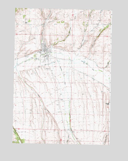
Prairie City, OR USGS Topographic Map
Click on map above to begin viewing in our Map Viewer.

This topographic map contains these locations and features:
Feature Name Type Latitude Longitude GNIS ID View Map
A Coombs RanchLocaleN44.4296°W118.6274°1156210View Map
B Standbro RanchLocaleN44.4529°W118.6805°1156217View Map
Camp Logan (historical)MilitaryN44.3875°W118.6750°1154078View Map
Carter RanchLocaleN44.4427°W118.6291°1156213View Map
City of Prairie CityCivilN44.4611°W118.7094°2411484View Map
Cline DrawArroyoN44.4429°W118.6274°1152957View Map
Dads CreekStreamN44.4532°W118.6727°1140586View Map
Dans CreekStreamN44.4440°W118.6363°1140620View Map
Depot Park Recreation SiteParkN44.4618°W118.7063°1156219View Map
DeWitt MuseumBuildingN44.4580°W118.7061°2700321View Map
Dixie CreekStreamN44.4585°W118.7097°1141077View Map
Faiman SpringSpringN44.4866°W118.7374°1154081View Map
H Coombs RanchLocaleN44.4385°W118.6472°1156215View Map
Hi Country Number 2 AirportAirportN44.4351°W118.6617°2646048View Map
I Standbro RanchLocaleN44.4435°W118.6719°1156214View Map
Jeff Davis CreekStreamN44.4520°W118.6591°1144238View Map
McHaley CemeteryCemeteryN44.4619°W118.7181°1156948View Map
Oxbow RanchLocaleN44.4160°W118.6911°1147322View Map
Oxbow Ranch AirportAirportN44.4159°W118.6919°1154030View Map
Prairie CityPopulated PlaceN44.4632°W118.7099°1147975View Map
Prairie City BenchBenchN44.3777°W118.6872°1154079View Map
Prairie City CemeteryCemeteryN44.4565°W118.7038°1156949View Map
Prairie City DepotBuildingN44.4568°W118.7097°1156221View Map
Prairie City Fire DepartmentBuildingN44.4620°W118.7108°2576594View Map
Prairie City Forest Service DepotLocaleN44.3929°W118.7172°1167335View Map
Prairie City Police DepartmentBuildingN44.4619°W118.7109°2737775View Map
Prairie City Post OfficePost OfficeN44.4622°W118.7096°1165816View Map
Prairie City Public Works Department OfficeBuildingN44.4628°W118.7081°2700364View Map
Prairie City Ranger StationBuildingN44.4604°W118.7136°1156220View Map
Prairie City ReservoirReservoirN44.4653°W118.7065°1154083View Map
Prairie City SchoolSchoolN44.4561°W118.7092°1166862View Map
Prairie City Town HallBuildingN44.4619°W118.7108°2700286View Map
Prairie Wood Products Cogen 1 Biomass FacilityLocaleN44.4591°W118.7175°2699725View Map
Ray RanchLocaleN44.3865°W118.7488°1155448View Map
Sharp CreekStreamN44.3910°W118.6783°1150244View Map
Shaw GulchValleyN44.4443°W118.7491°1149299View Map
Slaughterhouse GulchValleyN44.4596°W118.7024°1149670View Map
Snow CreekStreamN44.4235°W118.7261°1154080View Map
Strawberry CreekStreamN44.4590°W118.7011°1150479View Map
Susie CreekStreamN44.4513°W118.7330°1162410View Map
The Mill DitchCanalN44.4482°W118.7055°1151026View Map
Velvin RanchLocaleN44.4507°W118.6566°1156218View Map
Walden SpringsSpringN44.4401°W118.6594°1154082View Map
Warm Springs BranchStreamN44.4513°W118.6566°1152965View Map
Winegar RanchLocaleN44.4574°W118.6680°1156216View Map

Note: Coordinates in the location and feature list above are referenced to NAD83 datum.


Copyright (C) 2008-2025 Ryan Niemi / Sunset Dynamics ... All Rights Reserved