TopoQuest Logo
Do you find TopoQuest useful?
Help keep TopoQuest running and adding new maps/features by donating!
Bitcoin:  19c7KJd3qBynnjoSw5npx9KScwjBe4ifkT
Litecoin:  LXs6TkuXGGXo1vDsWCkWVdjQX94eUKd6ui
Home View Maps Find Maps Find Places Resources & Links


Castle Creek, Oregon Topographic Map

USGS Map Title: Castle Creek, OR
USGS Map MRC: 44118D7
DRG (GeoTIFF) Download: o44118d7.tif


Neighboring USGS Topographic Map Quads:


  Magone Lake, OR  
44118E8
 

  Cougar Rock, OR  
44118E7
 

  Dixie Meadows, OR  
44118E6
 

  John Day, OR  
44118D8
 

  Castle Creek, OR  
44118D7
 

  Prairie City, OR  
44118D6
 

  Canyon Mountain, OR  
44118C8
 

  Pine Creek Mountain, OR  
44118C7
 

  Strawberry Mountain, OR  
44118C6


Map MRC Location:

N45°
W119°
N45°
W118°
H8 H7 H6 H5 H4 H3 H2 H1
G8 G7 G6 G5 G4 G3 G2 G1
F8 F7 F6 F5 F4 F3 F2 F1
E8 E7 E6 E5 E4 E3 E2 E1
D8 D7 D6 D5 D4 D3 D2 D1
C8 C7 C6 C5 C4 C3 C2 C1
B8 B7 B6 B5 B4 B3 B2 B1
A8 A7 A6 A5 A4 A3 A2 A1
N44°
W119°
N44°
W118°

Castle Creek, OR USGS 1:24K Topographic Map Preview:
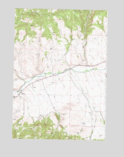
Castle Creek, OR USGS Topographic Map
Click on map above to begin viewing in our Map Viewer.

This topographic map contains these locations and features:
Feature Name Type Latitude Longitude GNIS ID View Map
Bear CreekStreamN44.4413°W118.7769°1137685View Map
Bear GulchValleyN44.3868°W118.8155°1137716View Map
Big GulchValleyN44.4424°W118.7711°1152799View Map
Birch SpringSpringN44.3835°W118.8669°1138152View Map
Butch Foster SaddleGapN44.4838°W118.8552°1139031View Map
Castle CreekStreamN44.4382°W118.8238°1139439View Map
Clark RanchLocaleN44.4024°W118.7605°1167248View Map
Cottonwood SpringSpringN44.4714°W118.7982°1140197View Map
Dead Horse SpringSpringN44.3766°W118.7990°1140699View Map
Dean CreekStreamN44.4202°W118.8691°1140765View Map
Deep GulchValleyN44.4371°W118.8377°1140812View Map
Dissel CreekStreamN44.4199°W118.8697°1141051View Map
Fisk CreekStreamN44.4379°W118.8163°1142183View Map
Grub CreekStreamN44.4290°W118.8588°1143142View Map
Gwyn CreekStreamN44.3904°W118.8133°1143171View Map
H Coombs RanchLocaleN44.4457°W118.7780°1167246View Map
H Ricco RanchLocaleN44.4407°W118.8008°1167245View Map
Hall HillSummitN44.4482°W118.7691°1158689View Map
Hardy SpringSpringN44.4620°W118.8267°1143304View Map
Holiday RanchLocaleN44.4324°W118.8411°1156173View Map
Holliday RanchLocaleN44.4310°W118.8455°1167244View Map
Howard RanchLocaleN44.3754°W118.7699°1167250View Map
Indian CreekStreamN44.4427°W118.8002°1144035View Map
Indian Creek School (historical)SchoolN44.3956°W118.7606°1156162View Map
John Day River DamDamN44.4407°W118.7830°1159370View Map
Johnson RanchLocaleN44.3882°W118.7766°1167247View Map
Johnson SpringsSpringN44.3818°W118.7891°1144366View Map
Jones SpringSpringN44.4296°W118.8235°1144386View Map
Kuhl RanchLocaleN44.4188°W118.7744°1167249View Map
Little Indian CreekStreamN44.4032°W118.7633°1145186View Map
McKinney CreekStreamN44.4160°W118.7761°1146011View Map
Oliver RanchLocaleN44.4174°W118.8686°1156166View Map
Oliver RockLocaleN44.4174°W118.8686°1167243View Map
Pine CreekStreamN44.4379°W118.8280°1147694View Map
Prairie City Wastewater Treatment LagoonsLocaleN44.4585°W118.7754°2697178View Map
Prairie DiggingsLocaleN44.4010°W118.8725°1147981View Map
Red HillSummitN44.3882°W118.8419°1148303View Map
West Fork Little Indian CreekStreamN44.3796°W118.7697°1152091View Map
West Fork Pine CreekStreamN44.4346°W118.8422°1152805View Map

Note: Coordinates in the location and feature list above are referenced to NAD83 datum.


Copyright (C) 2008-2024 Ryan Niemi / Sunset Dynamics ... All Rights Reserved