TopoQuest Logo
Do you find TopoQuest useful?
Help keep TopoQuest running and adding new maps/features by donating!
Bitcoin:  19c7KJd3qBynnjoSw5npx9KScwjBe4ifkT
Litecoin:  LXs6TkuXGGXo1vDsWCkWVdjQX94eUKd6ui
Home View Maps Find Maps Find Places Resources & Links


Pretoria, Georgia Topographic Map

USGS Map Title: Pretoria, GA
USGS Map MRC: 31084E3
DRG (GeoTIFF) Download: o31084e3.tif


Neighboring USGS Topographic Map Quads:


  Chickasawhatchee, GA  
31084F4
 

  Sasser, GA  
31084F3
 

  Leesburg, GA  
31084F2
 

  Holt, GA  
31084E4
 

  Pretoria, GA  
31084E3
 

  Albany West, GA  
31084E2
 

  Bermuda, GA  
31084D4
 

  Red Store Crossroads, GA  
31084D3
 

  Baconton North, GA  
31084D2


Map MRC Location:

N32°
W85°
N32°
W84°
H8 H7 H6 H5 H4 H3 H2 H1
G8 G7 G6 G5 G4 G3 G2 G1
F8 F7 F6 F5 F4 F3 F2 F1
E8 E7 E6 E5 E4 E3 E2 E1
D8 D7 D6 D5 D4 D3 D2 D1
C8 C7 C6 C5 C4 C3 C2 C1
B8 B7 B6 B5 B4 B3 B2 B1
A8 A7 A6 A5 A4 A3 A2 A1
N31°
W85°
N31°
W84°

Pretoria, GA USGS 1:24K Topographic Map Preview:
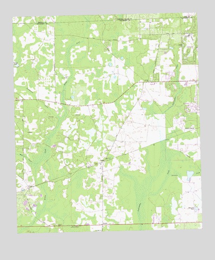
Pretoria, GA USGS Topographic Map
Click on map above to begin viewing in our Map Viewer.

This topographic map contains these locations and features:
Feature Name Type Latitude Longitude GNIS ID View Map
Albany Fire Department Station 10BuildingN31.5862°W84.2843°2604162View Map
BrookhollowPopulated PlaceN31.5657°W84.2535°1671050View Map
Cedar LakePopulated PlaceN31.5680°W84.2532°1671058View Map
DoublegatePopulated PlaceN31.5988°W84.2555°1671077View Map
Doublegate Country ClubLocaleN31.6121°W84.2555°344229View Map
DuckerPopulated PlaceN31.5263°W84.3660°326251View Map
Gillionville ChurchChurchN31.5852°W84.2805°1671117View Map
Gillionville ForestPopulated PlaceN31.5885°W84.2791°1671118View Map
Horse Lot PondLakeN31.5119°W84.2539°315697View Map
Indian CreekPopulated PlaceN31.5699°W84.2549°1671142View Map
Lockett CrossingPopulated PlaceN31.5577°W84.2541°332252View Map
Mossy Grove CemeteryCemeteryN31.5763°W84.3691°1671174View Map
Mossy Grove ChurchChurchN31.5768°W84.3691°318537View Map
Mud CreekStreamN31.5405°W84.3630°319106View Map
New Hope ChurchChurchN31.5010°W84.3180°319373View Map
New Zion Hill Church (historical)ChurchN31.5043°W84.3071°1671185View Map
Oak Grove ChurchChurchN31.5421°W84.3141°319774View Map
Oak Hill ChurchChurchN31.5863°W84.2838°319829View Map
Percosin CreekStreamN31.5316°W84.2716°320383View Map
Pine Knoll Landing Field (historical)AirportN31.5427°W84.3427°1671208View Map
PretoriaPopulated PlaceN31.5043°W84.3171°321132View Map
Rush PondLakeN31.5296°W84.2505°322009View Map
SpringfieldPopulated PlaceN31.5877°W84.2713°1671253View Map
Tallahassee CreekStreamN31.5668°W84.3452°323890View Map
VancisePopulated PlaceN31.6168°W84.2819°1671270View Map
WalkerPopulated PlaceN31.5405°W84.3149°333343View Map
West Dougherty Community HouseBuildingN31.5035°W84.3330°325042View Map
West Dougherty DivisionCivilN31.5318°W84.2937°1936637View Map
Yancey PondReservoirN31.5972°W84.3725°325598View Map
YMCA Sports ParkParkN31.5849°W84.2744°1671294View Map

Note: Coordinates in the location and feature list above are referenced to NAD83 datum.


Copyright (C) 2008-2024 Ryan Niemi / Sunset Dynamics ... All Rights Reserved