TopoQuest Logo
Do you find TopoQuest useful?
Help keep TopoQuest running and adding new maps/features by donating!
Bitcoin:  19c7KJd3qBynnjoSw5npx9KScwjBe4ifkT
Litecoin:  LXs6TkuXGGXo1vDsWCkWVdjQX94eUKd6ui
Home View Maps Find Maps Find Places Resources & Links


Bermuda, Georgia Topographic Map

USGS Map Title: Bermuda, GA
USGS Map MRC: 31084D4
DRG (GeoTIFF) Download: o31084d4.tif


Neighboring USGS Topographic Map Quads:


  Morgan, GA  
31084E5
 

  Holt, GA  
31084E4
 

  Pretoria, GA  
31084E3
 

  Leary, GA  
31084D5
 

  Bermuda, GA  
31084D4
 

  Red Store Crossroads, GA  
31084D3
 

  Bethany, GA  
31084C5
 

  Elmodel, GA  
31084C4
 

  Newton, GA  
31084C3


Map MRC Location:

N32°
W85°
N32°
W84°
H8 H7 H6 H5 H4 H3 H2 H1
G8 G7 G6 G5 G4 G3 G2 G1
F8 F7 F6 F5 F4 F3 F2 F1
E8 E7 E6 E5 E4 E3 E2 E1
D8 D7 D6 D5 D4 D3 D2 D1
C8 C7 C6 C5 C4 C3 C2 C1
B8 B7 B6 B5 B4 B3 B2 B1
A8 A7 A6 A5 A4 A3 A2 A1
N31°
W85°
N31°
W84°

Bermuda, GA USGS 1:24K Topographic Map Preview:
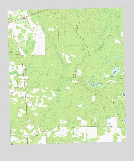
Bermuda, GA USGS Topographic Map
Click on map above to begin viewing in our Map Viewer.

This topographic map contains these locations and features:
Feature Name Type Latitude Longitude GNIS ID View Map
Alligator LakeLakeN31.4004°W84.3853°310486View Map
BermudaPopulated PlaceN31.4891°W84.4916°331138View Map
Bird Roost PondLakeN31.4421°W84.3849°311451View Map
Blue SpringSpringN31.3830°W84.4719°311554View Map
Clear LakeLakeN31.3923°W84.3928°312723View Map
Dry BranchStreamN31.4913°W84.4652°313646View Map
Fortysecond Street SwampSwampN31.4146°W84.3871°314302View Map
Hellgate PondLakeN31.4290°W84.4057°315304View Map
Hellgate SwampSwampN31.4310°W84.4057°315305View Map
Jones IslandIslandN31.4635°W84.4185°316241View Map
Keel CreekStreamN31.4235°W84.4460°316330View Map
Kiokee CreekStreamN31.4805°W84.3927°316467View Map
Liar LakeLakeN31.4155°W84.3822°316794View Map
Mayhall PondLakeN31.3932°W84.4105°317817View Map
Mole Grove ChurchChurchN31.3899°W84.4024°318382View Map
Mount Mary ChurchChurchN31.4916°W84.4449°318685View Map
Mount Pleasant CemeteryCemeteryN31.4477°W84.4616°318820View Map
Mount Pleasant ChurchChurchN31.4641°W84.4891°318832View Map
Mount Pleasant Church (historical)ChurchN31.4480°W84.4621°334764View Map
Pine IslandIslandN31.4860°W84.4132°320611View Map
Pleasant Hill CemeteryCemeteryN31.4591°W84.4877°320854View Map
Red BluffCliffN31.4332°W84.4335°321359View Map
Rock Hole PondLakeN31.4189°W84.3757°321739View Map
Saint Pauls Church (historical)ChurchN31.4663°W84.4457°334815View Map
Spring CreekStreamN31.4188°W84.4460°323381View Map
Twentythird Street SwampSwampN31.4080°W84.3769°324437View Map
West Chickasawhatchee CreekStreamN31.4571°W84.4119°310364View Map
White PondLakeN31.4611°W84.4993°325187View Map

Note: Coordinates in the location and feature list above are referenced to NAD83 datum.


Copyright (C) 2008-2025 Ryan Niemi / Sunset Dynamics ... All Rights Reserved