TopoQuest Logo
Do you find TopoQuest useful?
Help keep TopoQuest running and adding new maps/features by donating!
Bitcoin:  19c7KJd3qBynnjoSw5npx9KScwjBe4ifkT
Litecoin:  LXs6TkuXGGXo1vDsWCkWVdjQX94eUKd6ui
Home View Maps Find Maps Find Places Resources & Links


Priest River, Idaho Topographic Map

USGS Map Title: Priest River, ID
USGS Map MRC: 48116B8
DRG (GeoTIFF) Download: o48116b8.tif


Neighboring USGS Topographic Map Quads:


  Bead Lake, WA  
48117C1
 

  Quartz Mountain, ID  
48116C8
 

  Prater Mountain, ID  
48116C7
 

  Newport, WA  
48117B1
 

  Priest River, ID  
48116B8
 

  Laclede, ID  
48116B7
 

  Tweedie, WA  
48117A1
 

  Blanchard, ID  
48116A8
 

  Edgemere, ID  
48116A7


Map MRC Location:

N49°
W117°
N49°
W116°
H8 H7 H6 H5 H4 H3 H2 H1
G8 G7 G6 G5 G4 G3 G2 G1
F8 F7 F6 F5 F4 F3 F2 F1
E8 E7 E6 E5 E4 E3 E2 E1
D8 D7 D6 D5 D4 D3 D2 D1
C8 C7 C6 C5 C4 C3 C2 C1
B8 B7 B6 B5 B4 B3 B2 B1
A8 A7 A6 A5 A4 A3 A2 A1
N48°
W117°
N48°
W116°

Priest River, ID USGS 1:24K Topographic Map Preview:
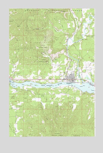
Priest River, ID USGS Topographic Map
Click on map above to begin viewing in our Map Viewer.

This topographic map contains these locations and features:
Feature Name Type Latitude Longitude GNIS ID View Map
Albeni Cove CampgroundLocaleN48.1760°W116.9991°394173View Map
Albeni Falls CampgroundLocaleN48.1763°W116.9983°395515View Map
Albeni Falls DamDamN48.1787°W116.9995°397365View Map
Albeni Falls Dam Picnic AreaLocaleN48.1799°W116.9971°394180View Map
Alder CreekStreamN48.1816°W116.8816°376518View Map
City of Priest RiverCivilN48.1782°W116.8840°2411492View Map
Flying H Ranch AirportAirportN48.2358°W116.8750°2443797View Map
Flying W Ranch AirportAirportN48.1893°W116.9913°2717102View Map
Lower West Branch Priest RiverStreamN48.2196°W116.9083°393803View Map
Newport Hill LookoutLocaleN48.2324°W116.9888°399145View Map
North Shore Game Management AreaParkN48.1763°W116.9516°394179View Map
Prep Alternative High SchoolSchoolN48.1903°W116.9158°401113View Map
Priest RiverPopulated PlaceN48.1807°W116.9094°397069View Map
Priest RiverStreamN48.1769°W116.8927°388878View Map
Priest River CampgroundLocaleN48.1771°W116.9030°394175View Map
Priest River Elementary SchoolSchoolN48.1862°W116.9114°401111View Map
Priest River Game Management AreaReserveN48.1794°W116.8858°401093View Map
Priest River High School (historical)SchoolN48.1894°W116.9171°400736View Map
Priest River Junior High SchoolSchoolN48.1811°W116.9189°401112View Map
Priest River Municipal AirportAirportN48.1893°W116.9122°400908View Map
Priest River ParkParkN48.1791°W116.8899°388880View Map
Priest River Police DepartmentBuildingN48.1794°W116.9066°2722469View Map
Priest River Post OfficePost OfficeN48.1799°W116.9046°2766867View Map
Sanborn CreekStreamN48.2221°W116.8910°389886View Map
Shepard StripAirportN48.1505°W116.9976°2770363View Map
Strong Island Picnic AreaLocaleN48.1757°W116.9646°394174View Map
Timberline CenterLocaleN48.1810°W116.9233°399312View Map
West Pend Oreille Fire District - Station 2BuildingN48.1792°W116.9065°2619329View Map

Note: Coordinates in the location and feature list above are referenced to NAD83 datum.


Copyright (C) 2008-2025 Ryan Niemi / Sunset Dynamics ... All Rights Reserved