TopoQuest Logo
Do you find TopoQuest useful?
Help keep TopoQuest running and adding new maps/features by donating!
Bitcoin:  19c7KJd3qBynnjoSw5npx9KScwjBe4ifkT
Litecoin:  LXs6TkuXGGXo1vDsWCkWVdjQX94eUKd6ui
Home View Maps Find Maps Find Places Resources & Links


Newport, Washington Topographic Map

USGS Map Title: Newport, WA
USGS Map MRC: 48117B1
DRG (GeoTIFF) Download: o48117b1.tif


Neighboring USGS Topographic Map Quads:


  Skookum Creek, WA  
48117C2
 

  Bead Lake, WA  
48117C1
 

  Quartz Mountain, ID  
48116C8
 

  Diamond Lake, WA  
48117B2
 

  Newport, WA  
48117B1
 

  Priest River, ID  
48116B8
 

  Camden, WA  
48117A2
 

  Tweedie, WA  
48117A1
 

  Blanchard, ID  
48116A8


Map MRC Location:

N49°
W118°
N49°
W117°
H8 H7 H6 H5 H4 H3 H2 H1
G8 G7 G6 G5 G4 G3 G2 G1
F8 F7 F6 F5 F4 F3 F2 F1
E8 E7 E6 E5 E4 E3 E2 E1
D8 D7 D6 D5 D4 D3 D2 D1
C8 C7 C6 C5 C4 C3 C2 C1
B8 B7 B6 B5 B4 B3 B2 B1
A8 A7 A6 A5 A4 A3 A2 A1
N48°
W118°
N48°
W117°

Newport, WA USGS 1:24K Topographic Map Preview:
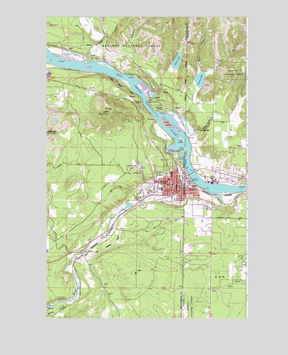
Newport, WA USGS Topographic Map
Click on map above to begin viewing in our Map Viewer.

This topographic map contains these locations and features:
Feature Name Type Latitude Longitude GNIS ID View Map
Albeni CoveBayN48.1755°W117.1219°376495View Map
Albeni FallsFallsN48.1777°W117.0013°376064View Map
Albeni Falls DamDamN48.1799°W117.0010°398907View Map
American Lutheran ChurchChurchN48.1735°W117.0702°2609703View Map
Bodie CanyonValleyN48.1993°W117.0677°377985View Map
Bodie Canyon MineMineN48.2077°W117.0774°377986View Map
Brier CreekStreamN48.2266°W117.0299°378230View Map
Church of FaithChurchN48.1808°W117.0480°2609704View Map
City of NewportCivilN48.1791°W117.0548°2411249View Map
City of OldtownCivilN48.1839°W117.0207°2411314View Map
Cooks IslandIslandN48.2057°W117.0474°1504121View Map
Cooks MountainSummitN48.2121°W117.0824°1504123View Map
Cuban CreekStreamN48.2288°W117.0299°380153View Map
Cuban HillSummitN48.2477°W117.0496°396351View Map
Duncan Dam Number 1DamN48.2382°W117.1244°1531993View Map
Duncan Dam Number 2DamN48.2349°W117.1144°1531992View Map
Exposure CreekStreamN48.2324°W117.0691°1519422View Map
First Baptist ChurchChurchN48.1798°W117.0459°2608878View Map
Freeman CreekStreamN48.2266°W117.0266°382036View Map
Freeman LakeLakeN48.2240°W117.0297°382039View Map
Freeman Lake Access AreaLocaleN48.2227°W117.0277°401330View Map
House of the Lord Christian AcademySchoolN48.1716°W117.0308°401484View Map
Idaho Hill Elementary SchoolSchoolN48.1794°W117.0352°401398View Map
Idaho SchoolSchoolN48.1796°W117.0349°383613View Map
Kelly IslandIslandN48.1932°W117.0388°384143View Map
KUBS-FM (Newport)TowerN48.1730°W117.0552°1534530View Map
Langell CanyonValleyN48.2030°W117.0299°384423View Map
Lazy Acres Mobile Home ParkPopulated PlaceN48.1734°W117.0490°2607393View Map
Lower West Branch Priest RiverStreamN48.2196°W117.0358°1522555View Map
Marshall CreekStreamN48.2316°W117.1022°1522747View Map
NewportPopulated PlaceN48.1796°W117.0433°1512505View Map
Newport Ambulance ServiceBuildingN48.1805°W117.0443°2643724View Map
Newport CemeteryCemeteryN48.1747°W117.0691°1506972View Map
Newport City HallBuildingN48.1799°W117.0436°2610584View Map
Newport City Police DepartmentBuildingN48.1798°W117.0436°2722019View Map
Newport Community Hospital HeliportAirportN48.1818°W117.0494°1533852View Map
Newport High SchoolSchoolN48.1771°W117.0621°1514817View Map
Newport HillSummitN48.2335°W117.1172°396955View Map
Newport Hospital and Health ServicesHospitalN48.1824°W117.0492°2607640View Map
Newport Landing Area (historical)AirportN48.1802°W117.0671°1534187View Map
Newport Post OfficePost OfficeN48.1813°W117.0436°2606903View Map
Newport Sewage Treatment PlantLocaleN48.1899°W117.0421°2610702View Map
Newport Southern Baptist ChurchChurchN48.1621°W117.0834°2609705View Map
OldtownPopulated PlaceN48.1788°W117.0380°396981View Map
Pend Oreille County CourthouseBuildingN48.1778°W117.0480°2610502View Map
Pend Oreille County Hall of JusticeBuildingN48.1784°W117.0591°2610503View Map
Pend Oreille Fire District 4 Station 42BuildingN48.2197°W117.0955°2643920View Map
Pend Oreille Sheriff's OfficeBuildingN48.1785°W117.0589°2721929View Map
PenrithPopulated PlaceN48.1521°W117.0994°1511542View Map
Pine Ridge Community ChurchChurchN48.1817°W117.0600°2609706View Map
Pioneer ParkParkN48.2119°W117.0535°1507464View Map
Rat IslandIslandN48.1988°W117.0399°389119View Map
Saddler CreekStreamN48.2213°W117.0402°389792View Map
Sadie Halstead Middle SchoolSchoolN48.1788°W117.0533°1514818View Map
Saint Anthony's Catholic ChurchChurchN48.1815°W117.0479°2609707View Map
Shearer LakeLakeN48.2315°W117.0439°1508263View Map
Stratton Elementary SchoolSchoolN48.1767°W117.0561°1530917View Map
Strong CreekStreamN48.1743°W117.1091°391542View Map
Strong IslandIslandN48.1763°W117.0941°391545View Map
United Church of Christ of NewportChurchN48.1794°W117.0451°2609708View Map
Willy-O LakeReservoirN48.2174°W117.0591°1532534View Map
Willy-O Lake DamDamN48.2182°W117.0594°1532533View Map

Note: Coordinates in the location and feature list above are referenced to NAD83 datum.


Copyright (C) 2008-2024 Ryan Niemi / Sunset Dynamics ... All Rights Reserved