TopoQuest Logo
Do you find TopoQuest useful?
Help keep TopoQuest running and adding new maps/features by donating!
Bitcoin:  19c7KJd3qBynnjoSw5npx9KScwjBe4ifkT
Litecoin:  LXs6TkuXGGXo1vDsWCkWVdjQX94eUKd6ui
Home View Maps Find Maps Find Places Resources & Links


Princeton West, Arkansas Topographic Map

USGS Map Title: Princeton West, AR
USGS Map MRC: 33092H6
DRG (GeoTIFF) Download: o33092h6.tif


Neighboring USGS Topographic Map Quads:


  Manning, AR  
34092A7
 

  Tulip, AR  
34092A6
 

  Carthage, AR  
34092A5
 

  Sparkman, AR  
33092H7
 

  Princeton West, AR  
33092H6
 

  Princeton East, AR  
33092H5
 

  Ouachita, AR  
33092G7
 

  Holly Springs, AR  
33092G6
 

  Hopeville, AR  
33092G5


Map MRC Location:

N34°
W93°
N34°
W92°
H8 H7 H6 H5 H4 H3 H2 H1
G8 G7 G6 G5 G4 G3 G2 G1
F8 F7 F6 F5 F4 F3 F2 F1
E8 E7 E6 E5 E4 E3 E2 E1
D8 D7 D6 D5 D4 D3 D2 D1
C8 C7 C6 C5 C4 C3 C2 C1
B8 B7 B6 B5 B4 B3 B2 B1
A8 A7 A6 A5 A4 A3 A2 A1
N33°
W93°
N33°
W92°

Princeton West, AR USGS 1:24K Topographic Map Preview:
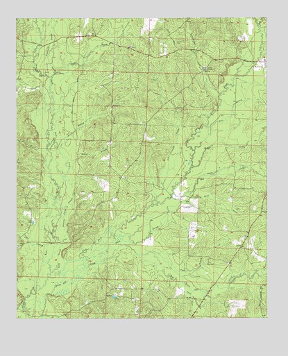
Princeton West, AR USGS Topographic Map
Click on map above to begin viewing in our Map Viewer.

This topographic map contains these locations and features:
Feature Name Type Latitude Longitude GNIS ID View Map
Alsobrook SloughGutN33.9762°W92.7349°45847View Map
Bear CreekStreamN33.9251°W92.7307°76265View Map
Beech CreekStreamN33.9270°W92.6715°46324View Map
Ben Few CampgroundLocaleN33.9793°W92.6557°46381View Map
Black SloughGutN33.8943°W92.7227°46677View Map
Campground CreekStreamN33.9690°W92.6477°76515View Map
Cooker BranchStreamN33.9376°W92.7241°47981View Map
Cruse (historical)Populated PlaceN33.9551°W92.6668°60966View Map
Dallas CountyCivilN33.9698°W92.6544°66849View Map
Dry CreekStreamN33.9220°W92.6835°76823View Map
Dry CreekStreamN33.9965°W92.6282°76824View Map
East Fork Tulip CreekStreamN33.8884°W92.7418°48765View Map
Futch BranchStreamN33.9457°W92.7285°49295View Map
Hall CreekStreamN33.9748°W92.7335°76146View Map
Henderson CemeteryCemeteryN33.9904°W92.6696°50005View Map
Herring CemeteryCemeteryN33.9201°W92.6252°50030View Map
Hickory Flats SloughGutN33.9115°W92.7313°50056View Map
JacintoPopulated PlaceN33.9045°W92.6382°57069View Map
Long SloughGutN33.8943°W92.7332°51444View Map
Macedonia ChurchChurchN33.9632°W92.7021°51570View Map
Martin CreekStreamN33.9382°W92.6618°77603View Map
Mitchell BranchStreamN33.8937°W92.6307°52105View Map
Mount Olivet ChurchChurchN33.8845°W92.7054°52367View Map
Mount Zion ChurchChurchN33.9884°W92.6935°52461View Map
Mud CreekStreamN33.9026°W92.6824°52511View Map
Nix (historical)Populated PlaceN33.9840°W92.7466°60973View Map
Oakhurst (historical)Populated PlaceN33.8807°W92.6910°60974View Map
Pride BranchStreamN33.9054°W92.7357°53797View Map
Red BranchStreamN33.9451°W92.6610°53938View Map
Sand CreekStreamN33.9259°W92.6668°54534View Map
Taylor BranchStreamN33.9023°W92.6799°55457View Map
Taylor CemeteryCemeteryN33.8979°W92.6554°55461View Map
Township of PrincetonCivilN33.9540°W92.6553°66493View Map
West Fork Tulip CreekStreamN33.8884°W92.7418°78725View Map
White Oak CreekStreamN33.8948°W92.6715°56276View Map

Note: Coordinates in the location and feature list above are referenced to NAD83 datum.


Copyright (C) 2008-2025 Ryan Niemi / Sunset Dynamics ... All Rights Reserved