TopoQuest Logo
Do you find TopoQuest useful?
Help keep TopoQuest running and adding new maps/features by donating!
Bitcoin:  19c7KJd3qBynnjoSw5npx9KScwjBe4ifkT
Litecoin:  LXs6TkuXGGXo1vDsWCkWVdjQX94eUKd6ui
Home View Maps Find Maps Find Places Resources & Links


Sparkman, Arkansas Topographic Map

USGS Map Title: Sparkman, AR
USGS Map MRC: 33092H7
DRG (GeoTIFF) Download: o33092h7.tif


Neighboring USGS Topographic Map Quads:


  Dalark, AR  
34092A8
 

  Manning, AR  
34092A7
 

  Tulip, AR  
34092A6
 

  Sparkman NW, AR  
33092H8
 

  Sparkman, AR  
33092H7
 

  Princeton West, AR  
33092H6
 

  Tates Bluff, AR  
33092G8
 

  Ouachita, AR  
33092G7
 

  Holly Springs, AR  
33092G6


Map MRC Location:

N34°
W93°
N34°
W92°
H8 H7 H6 H5 H4 H3 H2 H1
G8 G7 G6 G5 G4 G3 G2 G1
F8 F7 F6 F5 F4 F3 F2 F1
E8 E7 E6 E5 E4 E3 E2 E1
D8 D7 D6 D5 D4 D3 D2 D1
C8 C7 C6 C5 C4 C3 C2 C1
B8 B7 B6 B5 B4 B3 B2 B1
A8 A7 A6 A5 A4 A3 A2 A1
N33°
W93°
N33°
W92°

Sparkman, AR USGS 1:24K Topographic Map Preview:
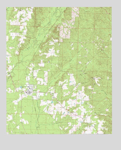
Sparkman, AR USGS Topographic Map
Click on map above to begin viewing in our Map Viewer.

This topographic map contains these locations and features:
Feature Name Type Latitude Longitude GNIS ID View Map
City of SparkmanCivilN33.9173°W92.8500°2405501View Map
Ebenezer ChurchChurchN33.9051°W92.7804°48805View Map
Erby CemeteryCemeteryN33.9329°W92.7865°82839View Map
First Baptist ChurchChurchN33.9179°W92.8488°63134View Map
Harmony Church CemeteryCemeteryN33.9345°W92.7832°49872View Map
Holeman CemeteryCemeteryN33.9987°W92.8435°50189View Map
Horse BranchStreamN33.8815°W92.8388°50324View Map
Key Hill Lookout TowerTowerN33.9304°W92.7727°82465View Map
Macedonia ChurchChurchN33.9748°W92.8560°51571View Map
Mount Carmel CemeteryCemeteryN33.8829°W92.7782°52271View Map
New HopePopulated PlaceN33.8959°W92.7979°57136View Map
New Hope Baptist ChurchChurchN33.8954°W92.7971°63138View Map
Old New Hope CemeteryCemeteryN33.9243°W92.7721°53009View Map
Pine GrovePopulated PlaceN33.8823°W92.7718°78009View Map
Sardis Methodist ChurchChurchN33.8948°W92.7699°78297View Map
Shady Grove Baptist ChurchChurchN33.9968°W92.8588°78325View Map
SparkmanPopulated PlaceN33.9168°W92.8482°58666View Map
Sparkman CemeteryCemeteryN33.9154°W92.8229°55055View Map
Sparkman Elementary SchoolSchoolN33.9154°W92.8538°60976View Map
Sparkman Fire DepartmentBuildingN33.9168°W92.8475°2117158View Map
Sparkman Fire Station Old StationBuildingN33.9159°W92.8483°2117159View Map
Sparkman High SchoolSchoolN33.9162°W92.8514°60977View Map
Sparkman Memorial CemeteryCemeteryN33.9314°W92.8432°55056View Map
Sparkman Police DepartmentBuildingN33.9166°W92.8465°2118828View Map
Township of NixCivilN33.9917°W92.7732°66491View Map
Township of OwenCivilN33.8834°W92.8258°66492View Map
Williams CemeteryCemeteryN33.9370°W92.7849°56386View Map

Note: Coordinates in the location and feature list above are referenced to NAD83 datum.


Copyright (C) 2008-2025 Ryan Niemi / Sunset Dynamics ... All Rights Reserved