TopoQuest Logo
Do you find TopoQuest useful?
Help keep TopoQuest running and adding new maps/features by donating!
Bitcoin:  19c7KJd3qBynnjoSw5npx9KScwjBe4ifkT
Litecoin:  LXs6TkuXGGXo1vDsWCkWVdjQX94eUKd6ui
Home View Maps Find Maps Find Places Resources & Links


Proctor, Montana Topographic Map

USGS Map Title: Proctor, MT
USGS Map MRC: 47114H3
DRG (GeoTIFF) Download: o47114h3.tif


Neighboring USGS Topographic Map Quads:


  Kila, MT  
48114A4
 

  Lion Mountain, MT  
48114A3
 

  Somers, MT  
48114A2
 

  Lake Mary Ronan, MT  
47114H4
 

  Proctor, MT  
47114H3
 

  Rollins, MT  
47114H2
 

  Irvine Lookout Tower, MT  
47114G4
 

  Elmo, MT  
47114G3
 

  Wild Horse Island, MT  
47114G2


Map MRC Location:

N48°
W115°
N48°
W114°
H8 H7 H6 H5 H4 H3 H2 H1
G8 G7 G6 G5 G4 G3 G2 G1
F8 F7 F6 F5 F4 F3 F2 F1
E8 E7 E6 E5 E4 E3 E2 E1
D8 D7 D6 D5 D4 D3 D2 D1
C8 C7 C6 C5 C4 C3 C2 C1
B8 B7 B6 B5 B4 B3 B2 B1
A8 A7 A6 A5 A4 A3 A2 A1
N47°
W115°
N47°
W114°

Proctor, MT USGS 1:24K Topographic Map Preview:
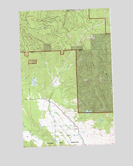
Proctor, MT USGS Topographic Map
Click on map above to begin viewing in our Map Viewer.

This topographic map contains these locations and features:
Feature Name Type Latitude Longitude GNIS ID View Map
Basin MeadowsFlatN47.9338°W114.3276°779422View Map
Bickford SpringSpringN47.8888°W114.2717°779748View Map
Big 4 MineMineN47.9647°W114.3518°802988View Map
East Fork Dayton CreekStreamN47.9308°W114.3279°782831View Map
Foss SpringSpringN47.8874°W114.2942°783623View Map
Grants MeadowSwampN47.9331°W114.3570°784189View Map
Indian SpringSpringN47.9060°W114.3287°785280View Map
Jumbo MineMineN47.9530°W114.3598°803666View Map
Kerr MountainSummitN47.9786°W114.3390°785695View Map
Middle Fork Dayton CreekStreamN47.9297°W114.3298°787262View Map
Mikes PondLakeN47.8847°W114.3003°787339View Map
ProctorPopulated PlaceN47.8924°W114.3054°789200View Map
Proctor Post Office (historical)Post OfficeN47.8927°W114.3047°1796840View Map
Proctor School (historical)SchoolN47.8930°W114.3101°1796839View Map
Red LakeLakeN47.8804°W114.3317°789453View Map
Ronan CreekStreamN47.8752°W114.3054°789759View Map
Row LakeLakeN47.8979°W114.2686°789819View Map
Skags LakeLakeN47.9052°W114.2854°790574View Map
Spring CreekStreamN47.8905°W114.3065°778838View Map
Webb LakeLakeN47.9383°W114.3709°792909View Map
West Fork Dayton CreekStreamN47.9297°W114.3298°793011View Map

Note: Coordinates in the location and feature list above are referenced to NAD83 datum.


Copyright (C) 2008-2024 Ryan Niemi / Sunset Dynamics ... All Rights Reserved