TopoQuest Logo
Do you find TopoQuest useful?
Help keep TopoQuest running and adding new maps/features by donating!
Bitcoin:  19c7KJd3qBynnjoSw5npx9KScwjBe4ifkT
Litecoin:  LXs6TkuXGGXo1vDsWCkWVdjQX94eUKd6ui
Home View Maps Find Maps Find Places Resources & Links


Elmo, Montana Topographic Map

USGS Map Title: Elmo, MT
USGS Map MRC: 47114G3
DRG (GeoTIFF) Download: o47114g3.tif


Neighboring USGS Topographic Map Quads:


  Lake Mary Ronan, MT  
47114H4
 

  Proctor, MT  
47114H3
 

  Rollins, MT  
47114H2
 

  Irvine Lookout Tower, MT  
47114G4
 

  Elmo, MT  
47114G3
 

  Wild Horse Island, MT  
47114G2
 

  Irvine Hill, MT  
47114F4
 

  Buffalo Bridge, MT  
47114F3
 

  Polson, MT  
47114F2


Map MRC Location:

N48°
W115°
N48°
W114°
H8 H7 H6 H5 H4 H3 H2 H1
G8 G7 G6 G5 G4 G3 G2 G1
F8 F7 F6 F5 F4 F3 F2 F1
E8 E7 E6 E5 E4 E3 E2 E1
D8 D7 D6 D5 D4 D3 D2 D1
C8 C7 C6 C5 C4 C3 C2 C1
B8 B7 B6 B5 B4 B3 B2 B1
A8 A7 A6 A5 A4 A3 A2 A1
N47°
W115°
N47°
W114°

Elmo, MT USGS 1:24K Topographic Map Preview:
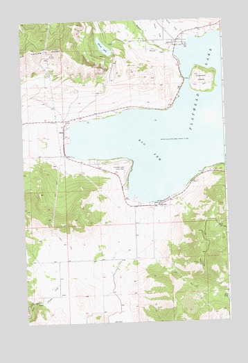
Elmo, MT USGS Topographic Map
Click on map above to begin viewing in our Map Viewer.

This topographic map contains these locations and features:
Feature Name Type Latitude Longitude GNIS ID View Map
23N21W04CBD_01 WellWellN47.7799°W114.3018°824937View Map
23N21W04CCD_01 WellWellN47.7774°W114.3021°824926View Map
23N21W05CDD_01 WellWellN47.7763°W114.3179°824920View Map
23N21W09CCD_01 WellWellN47.7630°W114.3026°824878View Map
23N21W09CCDA01 WellWellN47.7627°W114.3029°824876View Map
23N21W14BBB_01 WellWellN47.7608°W114.2615°824867View Map
23N21W18DBB_01 WellWellN47.7536°W114.3371°824827View Map
23N22W12DDC_01 WellWellN47.7619°W114.3529°824873View Map
24N21W02ACD_01 WellWellN47.8716°W114.2507°825134View Map
24N21W03CDB_01 WellWellN47.8655°W114.2798°825125View Map
24N21W04CDDC01 WellWellN47.8663°W114.2782°825127View Map
24N21W10BDCA01 WellWellN47.8569°W114.2782°825106View Map
24N21W16DAB_01 WellWellN47.8402°W114.2907°825084View Map
24N21W19BBD_01 WellWellN47.8316°W114.3471°825053View Map
24N21W19BCB_01 WellWellN47.8299°W114.3490°825048View Map
24N21W19BCCB01 WellWellN47.8277°W114.3465°825040View Map
24N21W26CBB_01 WellWellN47.8119°W114.2635°825007View Map
24N21W29ABB_01 WellWellN47.8177°W114.3162°825016View Map
24N21W32DDDD01 WellWellN47.7913°W114.3079°824966View Map
24N21W33ACC_01 WellWellN47.7991°W114.2962°824980View Map
24N21W33DBD_01 WellWellN47.7958°W114.2915°824973View Map
24N22W13DDB_01 WellWellN47.8361°W114.3529°825071View Map
24N22W14DDD_01 WellWellN47.8347°W114.3723°825069View Map
Arrowhead ResortLocaleN47.8172°W114.3357°1797041View Map
Barnacle Bobs RV Park/CampgroundLocaleN47.7980°W114.2948°1797037View Map
Big ArmBayN47.8213°W114.2971°768741View Map
Big ArmPopulated PlaceN47.7980°W114.2948°768742View Map
Big Arm CampgroundLocaleN47.8147°W114.3079°1797012View Map
Big Arm Census Designated PlaceCensusN47.7936°W114.2700°2407837View Map
Big Arm Fire DepartmentBuildingN47.7977°W114.2951°1796807View Map
Big Arm Mobile Home ParkPopulated PlaceN47.7986°W114.2954°1797043View Map
Big Arm Post OfficePost OfficeN47.7980°W114.2922°1796931View Map
Big Arm Resort and MarinaLocaleN47.7986°W114.2954°1797042View Map
Big Arm School (historical)SchoolN47.7997°W114.2954°1796930View Map
Black LakeLakeN47.8638°W114.3236°768972View Map
Chief CliffCliffN47.8547°W114.3237°769819View Map
Chief Cliff Volunteer Fire DepartmentBuildingN47.8306°W114.3493°1796806View Map
Cromwell IslandIslandN47.8502°W114.2637°770310View Map
DaytonPopulated PlaceN47.8658°W114.2790°770496View Map
Dayton Census Designated PlaceCensusN47.8643°W114.2766°2408645View Map
Dayton CreekStreamN47.8613°W114.2801°782129View Map
Dayton Post OfficePost OfficeN47.8678°W114.2822°1796923View Map
Dayton Presbyterian ChurchChurchN47.8658°W114.2754°1796976View Map
Dayton SchoolSchoolN47.8657°W114.2801°1796854View Map
Dillons Resort and MarinaLocaleN47.7980°W114.2948°1797039View Map
ElmoPopulated PlaceN47.8305°W114.3496°771209View Map
Elmo Census Designated PlaceCensusN47.8290°W114.3483°2408079View Map
Elmo Post OfficePost OfficeN47.8301°W114.3492°1796921View Map
Elmo School (historical)SchoolN47.8286°W114.3493°1796920View Map
Elmo-Dayton DistrictCivilN47.8175°W114.3109°2418932View Map
Flathead Lake State Park - Big Arm UnitParkN47.8130°W114.3101°771454View Map
Fort Lazy Y Trailer ParkPopulated PlaceN47.8283°W114.3476°1797040View Map
Happy Landen II ResortLocaleN47.7980°W114.2948°1797038View Map
Indian CemeteryCemeteryN47.8663°W114.2907°772682View Map
Kootenai CreekStreamN47.8622°W114.2862°773121View Map
KQRK-FM (Ronan)TowerN47.7736°W114.2687°806713View Map
Proctor CreekStreamN47.8636°W114.2798°789201View Map
Snowberg CourtPopulated PlaceN47.7991°W114.2932°1797044View Map
Spring CreekStreamN47.8666°W114.2718°778837View Map
Tribal Health DepartmentHospitalN47.8305°W114.3496°1797000View Map
Walstad Fishing Access SiteLocaleN47.8111°W114.2660°1744315View Map
Walstead ParkParkN47.8116°W114.2637°778092View Map

Note: Coordinates in the location and feature list above are referenced to NAD83 datum.


Copyright (C) 2008-2024 Ryan Niemi / Sunset Dynamics ... All Rights Reserved