TopoQuest Logo
Do you find TopoQuest useful?
Help keep TopoQuest running and adding new maps/features by donating!
Bitcoin:  19c7KJd3qBynnjoSw5npx9KScwjBe4ifkT
Litecoin:  LXs6TkuXGGXo1vDsWCkWVdjQX94eUKd6ui
Home View Maps Find Maps Find Places Resources & Links


Progreso, Texas Topographic Map

USGS Map Title: Progreso, TX
USGS Map MRC: 26097A8
DRG (GeoTIFF) Download: o26097a8.tif


Neighboring USGS Topographic Map Quads:


  Donna, TX  
26098B1
 

  Mercedes, TX  
26097B8
 

  La Feria, TX  
26097B7
 

  San Juan SE, TX  
26098A1
 

  Progreso, TX  
26097A8
 

  Santa Maria, TX  
26097A7


Map MRC Location:

N27°
W98°
N27°
W97°
H8 H7 H6 H5 H4 H3 H2 H1
G8 G7 G6 G5 G4 G3 G2 G1
F8 F7 F6 F5 F4 F3 F2 F1
E8 E7 E6 E5 E4 E3 E2 E1
D8 D7 D6 D5 D4 D3 D2 D1
C8 C7 C6 C5 C4 C3 C2 C1
B8 B7 B6 B5 B4 B3 B2 B1
A8 A7 A6 A5 A4 A3 A2 A1
N26°
W98°
N26°
W97°

Progreso, TX USGS 1:24K Topographic Map Preview:
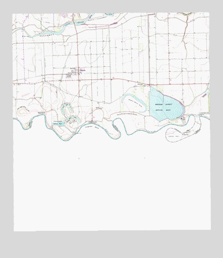
Progreso, TX USGS Topographic Map
Click on map above to begin viewing in our Map Viewer.

This topographic map contains these locations and features:
Feature Name Type Latitude Longitude GNIS ID View Map
A and E Ramirez ColoniaPopulated PlaceN26.0954°W97.9514°2009993View Map
A and E Ramirez Colonia Number 2Populated PlaceN26.0992°W97.9533°2009994View Map
Aqua Negra Banco Number 109LeveeN26.0712°W97.9939°1329641View Map
Arroyo AnacuitasValleyN26.1247°W97.8918°1329709View Map
B and P Bridge ColoniaPopulated PlaceN26.0673°W97.9503°2009940View Map
Bustamante ColoniaPopulated PlaceN26.1042°W97.8792°2009854View Map
Capetillo ColoniaPopulated PlaceN26.1034°W97.9442°2010490View Map
City of ProgresoCivilN26.0961°W97.9566°2411495View Map
City of Progreso LakesCivilN26.0712°W97.9588°2411496View Map
Colonia las PalmasPopulated PlaceN26.1034°W97.9492°2010483View Map
Dorothy Thompson Middle SchoolSchoolN26.0950°W97.9577°1985430View Map
Hidalgo County Juvenile Justice Alternative Education ProgramSchoolN26.0989°W97.9570°2434380View Map
Horcon TractCivilN26.0542°W97.8936°1338081View Map
J R Colonia Number 1Populated PlaceN26.1004°W97.9514°2011155View Map
J R Colonia Number 2Populated PlaceN26.1015°W97.9453°2011156View Map
Jesus Maria ColoniaPopulated PlaceN26.1142°W97.9533°2011164View Map
La Frontera ColoniaPopulated PlaceN26.0923°W97.9492°2011167View Map
La Reyna ColoniaPopulated PlaceN26.0992°W97.9633°2011121View Map
Las Palomas Wildlife Management Area - MacWhorter UnitParkN26.1167°W97.9764°2028970View Map
Lion LakeLakeN26.0732°W97.9658°1339989View Map
Llano Grande Banco Number 112LeveeN26.0631°W97.9614°1340273View Map
Llano Grande LakeLakeN26.1146°W97.9743°1340274View Map
Los Leones ColoniaPopulated PlaceN26.1092°W97.9572°2011101View Map
Lyons ColoniaPopulated PlaceN26.0923°W97.9642°2011113View Map
Mercedes District Settling BasinReservoirN26.0663°W97.8927°1341367View Map
Mercedes District Settling Basin DamDamN26.0654°W97.8936°1863612View Map
Mercedes PumpBuildingN26.0645°W97.8925°1341369View Map
Mercedes Settling BasinReservoirN26.0702°W97.8988°1863613View Map
Moon LakeLakeN26.0657°W97.9628°1341856View Map
O and J ColoniaPopulated PlaceN26.1042°W97.9564°2011011View Map
Orchard Homes Addition Number 2 ColoniaPopulated PlaceN26.0915°W97.9642°2010979View Map
Oriente ColoniaPopulated PlaceN26.0942°W97.9403°2010980View Map
Parajitos ColoniaPopulated PlaceN26.0834°W97.9742°2010950View Map
ProgresoPopulated PlaceN26.0923°W97.9572°1388197View Map
Progreso AirportAirportN26.0815°W97.9376°1387370View Map
Progreso BendBendN26.0606°W97.9481°1344581View Map
Progreso City HallBuildingN26.0922°W97.9587°2753636View Map
Progreso District Settling BasinReservoirN26.0619°W97.9696°1344582View Map
Progreso East Elementary SchoolSchoolN26.0938°W97.9591°1985431View Map
Progreso High SchoolSchoolN26.0988°W97.9570°1985432View Map
Progreso Intermediate SchoolSchoolN26.0972°W97.9577°2434544View Map
Progreso LakesPopulated PlaceN26.0717°W97.9589°1388613View Map
Progreso Police DepartmentBuildingN26.0922°W97.9588°2335044View Map
Progreso Post OfficePost OfficeN26.0875°W97.9569°2732255View Map
Progreso PumpBuildingN26.0567°W97.9611°1344583View Map
Progreso Toll BridgeBridgeN26.0620°W97.9492°1344584View Map
Progreso West Elementary SchoolSchoolN26.1042°W97.9596°2434261View Map
Rancho TolucaLocaleN26.0709°W97.9456°2032056View Map
RelampagoPopulated PlaceN26.0851°W97.9186°1345031View Map
Relampago Census Designated PlaceCensusN26.0851°W97.9059°2409161View Map
Rice Addition ColoniaPopulated PlaceN26.0954°W97.9533°2010903View Map
Rio RicoPopulated PlaceN26.0562°W97.8900°1345246View Map
Rosario Banco Number 31LeveeN26.0737°W97.9211°1345549View Map
San Pedro Ranch CemeteryCemeteryN26.0770°W97.9814°1346451View Map
Santa Amalia ColoniaPopulated PlaceN26.0965°W97.9733°2010885View Map
Santa Juanita Banco Number 34LeveeN26.0687°W97.9792°1346652View Map
Santa Margarita Banco Number 30LeveeN26.0676°W97.9258°1346654View Map
Shull Addition ColoniaPopulated PlaceN26.0942°W97.9564°2010606View Map
Stephensons ColoniaPopulated PlaceN26.1115°W97.9133°2010588View Map
Todd Colonia Number 3Populated PlaceN26.0873°W97.9642°2010575View Map
Todds Colonia Number 1Populated PlaceN26.0892°W97.9642°2010576View Map
Todds Colonia Number 2Populated PlaceN26.0884°W97.9642°2010577View Map
TolucaPopulated PlaceN26.0709°W97.9442°1388203View Map
Waterfall Road ColoniaPopulated PlaceN26.1034°W97.9072°2011572View Map

Note: Coordinates in the location and feature list above are referenced to NAD83 datum.


Copyright (C) 2008-2024 Ryan Niemi / Sunset Dynamics ... All Rights Reserved