TopoQuest Logo
Do you find TopoQuest useful?
Help keep TopoQuest running and adding new maps/features by donating!
Bitcoin:  19c7KJd3qBynnjoSw5npx9KScwjBe4ifkT
Litecoin:  LXs6TkuXGGXo1vDsWCkWVdjQX94eUKd6ui
Home View Maps Find Maps Find Places Resources & Links


Prosperity, South Carolina Topographic Map

USGS Map Title: Prosperity, SC
USGS Map MRC: 34081B5
DRG (GeoTIFF) Download: o34081b5.tif


Neighboring USGS Topographic Map Quads:


  Newberry West, SC  
34081C6
 

  Newberry East, SC  
34081C5
 

  Pomaria, SC  
34081C4
 

  Silverstreet, SC  
34081B6
 

  Prosperity, SC  
34081B5
 

  Little Mountain, SC  
34081B4
 

  Denny, SC  
34081A6
 

  Delmar, SC  
34081A5
 

  Lake Murray West, SC  
34081A4


Map MRC Location:

N35°
W82°
N35°
W81°
H8 H7 H6 H5 H4 H3 H2 H1
G8 G7 G6 G5 G4 G3 G2 G1
F8 F7 F6 F5 F4 F3 F2 F1
E8 E7 E6 E5 E4 E3 E2 E1
D8 D7 D6 D5 D4 D3 D2 D1
C8 C7 C6 C5 C4 C3 C2 C1
B8 B7 B6 B5 B4 B3 B2 B1
A8 A7 A6 A5 A4 A3 A2 A1
N34°
W82°
N34°
W81°

Prosperity, SC USGS 1:24K Topographic Map Preview:
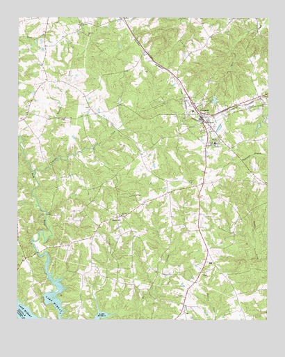
Prosperity, SC USGS Topographic Map
Click on map above to begin viewing in our Map Viewer.

This topographic map contains these locations and features:
Feature Name Type Latitude Longitude GNIS ID View Map
Antioch ChurchChurchN34.1974°W81.5262°1244902View Map
Big Creek School (historical)SchoolN34.1474°W81.5879°1228374View Map
Boozer ChapelChurchN34.2082°W81.6040°1246946View Map
BoydPopulated PlaceN34.2363°W81.5615°1228380View Map
Caldwells PondReservoirN34.2018°W81.5165°1237672View Map
Caldwells Pond D-1671 DamDamN34.2018°W81.5165°1237671View Map
Colony CemeteryCemeteryN34.2362°W81.5623°1228399View Map
Colony Lutheran ChurchChurchN34.2354°W81.5618°1247349View Map
Crofts Mill BridgeBridgeN34.1526°W81.6146°1228401View Map
Ebenezer CemeteryCemeteryN34.2462°W81.5898°1228411View Map
Ebenezer ChurchChurchN34.2468°W81.5937°1247616View Map
Hartford School (historical)SchoolN34.2290°W81.6126°1228424View Map
Hopewell ChurchChurchN34.2429°W81.5904°1246043View Map
Howard School (historical)SchoolN34.2154°W81.5418°1228432View Map
Kinards CreekStreamN34.1918°W81.6051°1229886View Map
Kinards School (historical)SchoolN34.2240°W81.6059°1228721View Map
Lever ChapelChurchN34.1760°W81.5670°1246340View Map
Lever Chapel School (historical)SchoolN34.1763°W81.5654°1228728View Map
Little CreekStreamN34.1271°W81.5837°1252030View Map
Monticello School (historical)SchoolN34.1571°W81.5307°1228746View Map
Newberry County Rural Fire Department Prosperity Station 2BuildingN34.2081°W81.5336°2578379View Map
Newberry County Rural Fire Department Stoney HillBuildingN34.1580°W81.5869°2578842View Map
O'Neal High School (historical)SchoolN34.1488°W81.5282°1251628View Map
ProsperityPopulated PlaceN34.2093°W81.5332°1250259View Map
Prosperity CemeteryCemeteryN34.1982°W81.5298°1228797View Map
Prosperity Elementary SchoolSchoolN34.2118°W81.5373°1228798View Map
Prosperity High School (historical)SchoolN34.2118°W81.5373°1228799View Map
Prosperity Lookout TowerTowerN34.1818°W81.5382°1228800View Map
Prosperity Police DepartmentBuildingN34.2116°W81.5373°2734313View Map
Rikard SchoolSchoolN34.1982°W81.5265°1250387View Map
Saint Lukes CemeteryCemeteryN34.1674°W81.5734°1228810View Map
Saint Lukes Lutheran ChurchChurchN34.1679°W81.5729°1250576View Map
Saluda Academy (historical)SchoolN34.1260°W81.5440°1228818View Map
Schumpert Mill (historical)LocaleN34.1682°W81.6109°1228819View Map
Shiloh CemeteryCemeteryN34.2165°W81.5423°1228826View Map
Shiloh ChurchChurchN34.2154°W81.5418°1250866View Map
Shiloh School (historical)SchoolN34.2160°W81.5423°1228827View Map
Stoney HillPopulated PlaceN34.1674°W81.5748°1251053View Map
Stoney Hill School (historical)SchoolN34.1654°W81.5795°1228835View Map
Timothy CreekStreamN34.1849°W81.6165°1227150View Map
Town of ProsperityCivilN34.2117°W81.5334°2407164View Map
Zion CemeteryCemeteryN34.1437°W81.5298°1228855View Map
Zion ChurchChurchN34.1435°W81.5304°1251552View Map

Note: Coordinates in the location and feature list above are referenced to NAD83 datum.


Copyright (C) 2008-2025 Ryan Niemi / Sunset Dynamics ... All Rights Reserved