TopoQuest Logo
Do you find TopoQuest useful?
Help keep TopoQuest running and adding new maps/features by donating!
Bitcoin:  19c7KJd3qBynnjoSw5npx9KScwjBe4ifkT
Litecoin:  LXs6TkuXGGXo1vDsWCkWVdjQX94eUKd6ui
Home View Maps Find Maps Find Places Resources & Links


Little Mountain, South Carolina Topographic Map

USGS Map Title: Little Mountain, SC
USGS Map MRC: 34081B4
DRG (GeoTIFF) Download: o34081b4.tif


Neighboring USGS Topographic Map Quads:


  Newberry East, SC  
34081C5
 

  Pomaria, SC  
34081C4
 

  Jenkinsville, SC  
34081C3
 

  Prosperity, SC  
34081B5
 

  Little Mountain, SC  
34081B4
 

  Chapin, SC  
34081B3
 

  Delmar, SC  
34081A5
 

  Lake Murray West, SC  
34081A4
 

  Lake Murray East, SC  
34081A3


Map MRC Location:

N35°
W82°
N35°
W81°
H8 H7 H6 H5 H4 H3 H2 H1
G8 G7 G6 G5 G4 G3 G2 G1
F8 F7 F6 F5 F4 F3 F2 F1
E8 E7 E6 E5 E4 E3 E2 E1
D8 D7 D6 D5 D4 D3 D2 D1
C8 C7 C6 C5 C4 C3 C2 C1
B8 B7 B6 B5 B4 B3 B2 B1
A8 A7 A6 A5 A4 A3 A2 A1
N34°
W82°
N34°
W81°

Little Mountain, SC USGS 1:24K Topographic Map Preview:
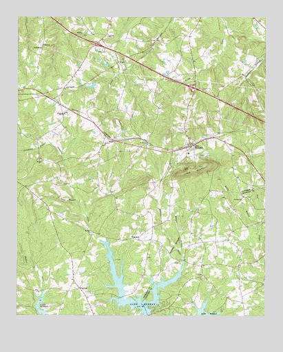
Little Mountain, SC USGS Topographic Map
Click on map above to begin viewing in our Map Viewer.

This topographic map contains these locations and features:
Feature Name Type Latitude Longitude GNIS ID View Map
Boland Crossroads (historical)Populated PlaceN34.1565°W81.4323°1228378View Map
Caughman School (historical)SchoolN34.1515°W81.4751°1228393View Map
Eptings PondReservoirN34.2214°W81.4624°1237674View Map
Eptings Pond D-1477 DamDamN34.2218°W81.4615°1237673View Map
FairviewPopulated PlaceN34.1368°W81.4684°1231272View Map
Fairview High School (historical)SchoolN34.1413°W81.4709°1253456View Map
Holy Trinity CemeteryCemeteryN34.1990°W81.4112°1228430View Map
Holy Trinity Evangelical Lutheran ChurchChurchN34.1971°W81.4118°1228429View Map
Interchange 82CrossingN34.2388°W81.4601°1228193View Map
Interchange 85CrossingN34.2204°W81.4109°1228194View Map
JollystreetLocaleN34.2379°W81.4876°1223627View Map
KiblerPopulated PlaceN34.2318°W81.4493°1246241View Map
Lexington County Fire Service Amicks FerryBuildingN34.1290°W81.3858°2578829View Map
Little MountainSummitN34.1868°W81.4137°1246412View Map
Little MountainPopulated PlaceN34.1963°W81.4123°1231486View Map
Little Mountain Elementary SchoolSchoolN34.1932°W81.4137°1228730View Map
Little Mountain School (historical)SchoolN34.1863°W81.3915°1228731View Map
Mayer CreekStreamN34.1668°W81.4649°2746457View Map
Mid Carolina High SchoolSchoolN34.2096°W81.4748°1224467View Map
Mid-Carolina Junior High SchoolSchoolN34.2099°W81.4748°1228743View Map
Millers BranchStreamN34.1485°W81.4173°1224572View Map
Mount Hebron CemeteryCemeteryN34.2426°W81.4670°1228717View Map
Mount Hebron ChurchChurchN34.2435°W81.4670°1249580View Map
Mount Hebron School (historical)SchoolN34.2432°W81.4668°1228750View Map
Mount Olive School (historical)SchoolN34.1643°W81.4679°1228753View Map
Mount Olive School (historical)SchoolN34.1565°W81.4390°1228754View Map
Mount Olivet CemeteryCemeteryN34.1593°W81.4629°1228756View Map
Mount Olivet Lutheran ChurchChurchN34.1599°W81.4634°1249625View Map
Mount Pilgrim CemeteryCemeteryN34.1901°W81.4882°1228757View Map
Mount Pilgrim Lutheran ChurchChurchN34.1907°W81.4890°1249643View Map
Mount Tabor CemeteryCemeteryN34.1968°W81.4340°1228760View Map
Mount Tabor Lutheran ChurchChurchN34.1974°W81.4345°1249683View Map
Mount Zion CemeteryCemeteryN34.1910°W81.4076°1228761View Map
Mount Zion ChurchChurchN34.1901°W81.4076°1228762View Map
Mount Zion School (historical)SchoolN34.1907°W81.4084°1228764View Map
Newberry County Rural Fire Department FairviewBuildingN34.1368°W81.4693°2578655View Map
Newberry County Rural Fire Department Little MountainBuildingN34.1970°W81.4142°2578317View Map
Oak Grove CemeteryCemeteryN34.1968°W81.4565°1228781View Map
Oak Grove ChurchChurchN34.1976°W81.4565°1249914View Map
Oak Grove School (historical)SchoolN34.1974°W81.4570°1228782View Map
Piney Woods School (historical)SchoolN34.1496°W81.4001°1244320View Map
Prosperity DivisionCivilN34.1745°W81.4924°1938393View Map
Providence ChurchChurchN34.1746°W81.3868°1225698View Map
Providence School (historical)SchoolN34.1765°W81.3873°1244330View Map
Rocky BranchStreamN34.1651°W81.3787°1225960View Map
Saint Pauls CemeteryCemeteryN34.2421°W81.4551°1228813View Map
Saint Pauls Lutheran ChurchChurchN34.2429°W81.4540°1250666View Map
Saint Peters ChurchChurchN34.1421°W81.4070°1226260View Map
SlighsPopulated PlaceN34.1985°W81.4504°1231805View Map
Snap BranchStreamN34.1729°W81.4687°1226721View Map
Stevens CreekStreamN34.1518°W81.4173°1251040View Map
Summers BranchStreamN34.2407°W81.3754°1251071View Map
Susannah BranchStreamN34.1979°W81.4840°1226979View Map
Town of Little MountainCivilN34.1970°W81.4127°2406025View Map
WheelandPopulated PlaceN34.1571°W81.4390°1227997View Map

Note: Coordinates in the location and feature list above are referenced to NAD83 datum.


Copyright (C) 2008-2025 Ryan Niemi / Sunset Dynamics ... All Rights Reserved