TopoQuest Logo
Do you find TopoQuest useful?
Help keep TopoQuest running and adding new maps/features by donating!
Bitcoin:  19c7KJd3qBynnjoSw5npx9KScwjBe4ifkT
Litecoin:  LXs6TkuXGGXo1vDsWCkWVdjQX94eUKd6ui
Home View Maps Find Maps Find Places Resources & Links


Raisin, Texas Topographic Map

USGS Map Title: Raisin, TX
USGS Map MRC: 28097F1
DRG (GeoTIFF) Download: o28097f1.tif


Neighboring USGS Topographic Map Quads:


  Schroeder, TX  
28097G2
 

  Victoria West, TX  
28097G1
 

  Victoria East, TX  
28096G8
 

  Fannin, TX  
28097F2
 

  Raisin, TX  
28097F1
 

  Bloomington, TX  
28096F8
 

  Lott Lake, TX  
28097E2
 

  McFaddin, TX  
28097E1
 

  Bloomington SW, TX  
28096E8


Map MRC Location:

N29°
W98°
N29°
W97°
H8 H7 H6 H5 H4 H3 H2 H1
G8 G7 G6 G5 G4 G3 G2 G1
F8 F7 F6 F5 F4 F3 F2 F1
E8 E7 E6 E5 E4 E3 E2 E1
D8 D7 D6 D5 D4 D3 D2 D1
C8 C7 C6 C5 C4 C3 C2 C1
B8 B7 B6 B5 B4 B3 B2 B1
A8 A7 A6 A5 A4 A3 A2 A1
N28°
W98°
N28°
W97°

Raisin, TX USGS 1:24K Topographic Map Preview:
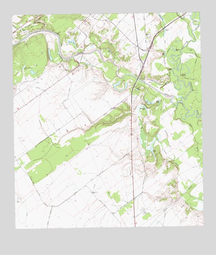
Raisin, TX USGS Topographic Map
Click on map above to begin viewing in our Map Viewer.

This topographic map contains these locations and features:
Feature Name Type Latitude Longitude GNIS ID View Map
Adler LakeLakeN28.6681°W97.0331°1350886View Map
Bass LakeLakeN28.6981°W97.0350°1351578View Map
Boggy CreekStreamN28.7414°W97.1036°1352577View Map
Coleto CreekStreamN28.6980°W97.0136°1354780View Map
Coleto Creek Oil FieldOilfieldN28.7319°W97.0722°1354781View Map
Cologne Oil FieldOilfieldN28.7080°W97.1194°1354807View Map
Court BranchStreamN28.7217°W97.0578°1355185View Map
Dry CreekStreamN28.7175°W97.0222°1356308View Map
Hog LakeLakeN28.7295°W97.0613°1359366View Map
Indian MoundSummitN28.7136°W97.0130°1359967View Map
Joshua CemeteryCemeteryN28.7117°W97.0217°1360434View Map
Kemper City SchoolSchoolN28.6456°W97.0733°1360562View Map
Mary LakeLakeN28.6991°W97.0289°1362245View Map
McDonald CemeteryCemeteryN28.6858°W97.0386°1362421View Map
McDonough BayouStreamN28.6639°W97.0189°1362418View Map
McDonough LakeLakeN28.6946°W97.0378°1362427View Map
Mill LakeLakeN28.7264°W97.0239°1362882View Map
New RiverStreamN28.7175°W97.0197°1363770View Map
Pridham LakeLakeN28.7475°W97.0263°1365784View Map
Primo StablesLocaleN28.6333°W97.0403°1365792View Map
RaisinPopulated PlaceN28.7422°W97.1197°1380411View Map
Raisin Volunteer Fire Department Station 2BuildingN28.6632°W97.1227°2552453View Map
Raisin Volunteer Fire Department Station 4BuildingN28.7127°W97.0873°2552450View Map
Reeves CemeteryCemeteryN28.7144°W97.0683°1366316View Map
Samson BayouStreamN28.7044°W97.0278°1367475View Map
Sand BayouGutN28.6775°W97.0061°1367549View Map
Sand LakeLakeN28.7056°W97.0435°1367621View Map
Shell and Trigger LakeLakeN28.7200°W97.1178°1368106View Map
Stubbs LakeLakeN28.7395°W97.0242°1369301View Map
Stubbs SchoolSchoolN28.7375°W97.0364°1369303View Map
Terrell LakeLakeN28.7338°W97.0856°1369735View Map
Terrell RanchLocaleN28.6408°W97.1217°1369737View Map
Victoria West DivisionCivilN28.7050°W97.0863°1939291View Map
Warden LakeLakeN28.7288°W97.0183°1370858View Map

Note: Coordinates in the location and feature list above are referenced to NAD83 datum.


Copyright (C) 2008-2025 Ryan Niemi / Sunset Dynamics ... All Rights Reserved