TopoQuest Logo
Do you find TopoQuest useful?
Help keep TopoQuest running and adding new maps/features by donating!
Bitcoin:  19c7KJd3qBynnjoSw5npx9KScwjBe4ifkT
Litecoin:  LXs6TkuXGGXo1vDsWCkWVdjQX94eUKd6ui
Home View Maps Find Maps Find Places Resources & Links


Rattan, Oklahoma Topographic Map

USGS Map Title: Rattan, OK
USGS Map MRC: 34095B4
DRG (GeoTIFF) Download: o34095b4.tif


Neighboring USGS Topographic Map Quads:


  Kosoma, OK  
34095C5
 

  Finley, OK  
34095C4
 

  Cloudy, OK  
34095C3
 

  Antlers East, OK  
34095B5
 

  Rattan, OK  
34095B4
 

  Spencerville, OK  
34095B3
 

  Hugo, OK  
34095A5
 

  Hugo Dam, OK  
34095A4
 

  Fort Towson, OK  
34095A3


Map MRC Location:

N35°
W96°
N35°
W95°
H8 H7 H6 H5 H4 H3 H2 H1
G8 G7 G6 G5 G4 G3 G2 G1
F8 F7 F6 F5 F4 F3 F2 F1
E8 E7 E6 E5 E4 E3 E2 E1
D8 D7 D6 D5 D4 D3 D2 D1
C8 C7 C6 C5 C4 C3 C2 C1
B8 B7 B6 B5 B4 B3 B2 B1
A8 A7 A6 A5 A4 A3 A2 A1
N34°
W96°
N34°
W95°

Rattan, OK USGS 1:24K Topographic Map Preview:
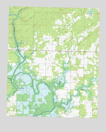
Rattan, OK USGS Topographic Map
Click on map above to begin viewing in our Map Viewer.

This topographic map contains these locations and features:
Feature Name Type Latitude Longitude GNIS ID View Map
ApplePopulated PlaceN34.1276°W95.4175°1100180View Map
BelzoniPopulated PlaceN34.1857°W95.4655°1100205View Map
Belzoni CemeteryCemeteryN34.1826°W95.4400°1089997View Map
Big Waterhole CreekStreamN34.2387°W95.4880°1090134View Map
Duck CreekStreamN34.2398°W95.4986°1092266View Map
Fish CreekStreamN34.2387°W95.3986°1092830View Map
Frazier CreekStreamN34.1370°W95.4336°1093025View Map
Glade BranchStreamN34.2026°W95.4158°1093197View Map
Hog CreekStreamN34.1687°W95.3761°1093818View Map
Hugo Wildlife Management AreaParkN34.1462°W95.4063°1763572View Map
Lake Ozzie CobbReservoirN34.2460°W95.3874°1096376View Map
Lick BranchStreamN34.2387°W95.4880°1094623View Map
Mill CreekStreamN34.1895°W95.4766°1095399View Map
Negro CreekStreamN34.1657°W95.4947°1095768View Map
Nelson BranchStreamN34.2409°W95.3986°1095787View Map
One CreekStreamN34.1568°W95.4864°1096273View Map
Ozzie Cobb Lake DamDamN34.2418°W95.3836°1751002View Map
Possum CreekStreamN34.2132°W95.4052°1096850View Map
RattanPopulated PlaceN34.2004°W95.4130°1097052View Map
Rattan CemeteryCemeteryN34.1912°W95.4013°1097053View Map
Rattan Elementary SchoolSchoolN34.1992°W95.4213°1790772View Map
Rattan Fire DepartmentBuildingN34.2001°W95.4127°2657186View Map
Rattan High SchoolSchoolN34.1992°W95.4213°1790443View Map
Rattan Junior High SchoolSchoolN34.1992°W95.4213°1790444View Map
Rattan Police DepartmentBuildingN34.1983°W95.4141°2757959View Map
Rock CreekStreamN34.1579°W95.4419°1097298View Map
Spencer CreekStreamN34.1595°W95.3897°1098352View Map
Town of RattanCivilN34.2004°W95.4131°2412531View Map
Waterfowl RefugeParkN34.1454°W95.4497°1763571View Map

Note: Coordinates in the location and feature list above are referenced to NAD83 datum.


Copyright (C) 2008-2025 Ryan Niemi / Sunset Dynamics ... All Rights Reserved