TopoQuest Logo
Do you find TopoQuest useful?
Help keep TopoQuest running and adding new maps/features by donating!
Bitcoin:  19c7KJd3qBynnjoSw5npx9KScwjBe4ifkT
Litecoin:  LXs6TkuXGGXo1vDsWCkWVdjQX94eUKd6ui
Home View Maps Find Maps Find Places Resources & Links


Spencerville, Oklahoma Topographic Map

USGS Map Title: Spencerville, OK
USGS Map MRC: 34095B3
DRG (GeoTIFF) Download: o34095b3.tif


Neighboring USGS Topographic Map Quads:


  Finley, OK  
34095C4
 

  Cloudy, OK  
34095C3
 

  Caney Mountain, OK  
34095C2
 

  Rattan, OK  
34095B4
 

  Spencerville, OK  
34095B3
 

  Sobol, OK  
34095B2
 

  Hugo Dam, OK  
34095A4
 

  Fort Towson, OK  
34095A3
 

  Swink, OK  
34095A2


Map MRC Location:

N35°
W96°
N35°
W95°
H8 H7 H6 H5 H4 H3 H2 H1
G8 G7 G6 G5 G4 G3 G2 G1
F8 F7 F6 F5 F4 F3 F2 F1
E8 E7 E6 E5 E4 E3 E2 E1
D8 D7 D6 D5 D4 D3 D2 D1
C8 C7 C6 C5 C4 C3 C2 C1
B8 B7 B6 B5 B4 B3 B2 B1
A8 A7 A6 A5 A4 A3 A2 A1
N34°
W96°
N34°
W95°

Spencerville, OK USGS 1:24K Topographic Map Preview:
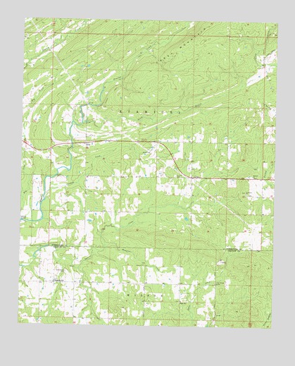
Spencerville, OK USGS Topographic Map
Click on map above to begin viewing in our Map Viewer.

This topographic map contains these locations and features:
Feature Name Type Latitude Longitude GNIS ID View Map
Black Jack Indian CemeteryCemeteryN34.1864°W95.2605°2708533View Map
Blackjack ChurchChurchN34.1865°W95.2611°1090230View Map
CorinnePopulated PlaceN34.1859°W95.2913°1100322View Map
Corinne CemeteryCemeteryN34.1865°W95.2994°1091687View Map
Crooked CreekStreamN34.1762°W95.3636°1091833View Map
Frazier Creek TrailTrailN34.2420°W95.3088°1093026View Map
Goodwater CemeteryCemeteryN34.1803°W95.2644°2708537View Map
Goodwater ChurchChurchN34.1801°W95.2641°1093257View Map
Hampton Chapel CemeteryCemeteryN34.1508°W95.3147°2723908View Map
Hampton ChurchChurchN34.1501°W95.3141°1093501View Map
Hampton CreekStreamN34.1573°W95.3336°1093502View Map
High BridgeLocaleN34.1420°W95.2783°1093729View Map
High HillPopulated PlaceN34.1351°W95.2969°1100494View Map
High Hill CemeteryCemeteryN34.1353°W95.2958°2723909View Map
Oknoname 127003 DamDamN34.1701°W95.2936°1755803View Map
Oknoname 127003 ReservoirReservoirN34.1691°W95.2932°1755804View Map
OletaPopulated PlaceN34.1995°W95.3438°1100696View Map
South Branch Frazier CreekStreamN34.2076°W95.3458°1098212View Map
SpencervillePopulated PlaceN34.1423°W95.3583°1098356View Map
Spencerville CemeteryCemeteryN34.1468°W95.3525°1098357View Map
Spencerville Fire DepartmentBuildingN34.1427°W95.3600°2657286View Map
Turkey CreekStreamN34.1812°W95.2511°1101894View Map

Note: Coordinates in the location and feature list above are referenced to NAD83 datum.


Copyright (C) 2008-2024 Ryan Niemi / Sunset Dynamics ... All Rights Reserved