TopoQuest Logo
Do you find TopoQuest useful?
Help keep TopoQuest running and adding new maps/features by donating!
Bitcoin:  19c7KJd3qBynnjoSw5npx9KScwjBe4ifkT
Litecoin:  LXs6TkuXGGXo1vDsWCkWVdjQX94eUKd6ui
Home View Maps Find Maps Find Places Resources & Links


Rattlesnake Spring, Arizona Topographic Map

USGS Map Title: Rattlesnake Spring, AZ
USGS Map MRC: 33109A2
DRG (GeoTIFF) Download: o33109a2.tif


Neighboring USGS Topographic Map Quads:


  Mitchell Peak, AZ  
33109B3
 

  Dix Creek, AZ  
33109B2
 

  Harden Cienega, NM  
33109B1
 

  Clifton, AZ  
33109A3
 

  Rattlesnake Spring, AZ  
33109A2
 

  Big Lue Mountains, AZ  
33109A1
 

  Guthrie, AZ  
32109H3
 

  York, AZ  
32109H2
 

  Tillie Hall Peak, NM  
32109H1


Map MRC Location:

N34°
W110°
N34°
W109°
H8 H7 H6 H5 H4 H3 H2 H1
G8 G7 G6 G5 G4 G3 G2 G1
F8 F7 F6 F5 F4 F3 F2 F1
E8 E7 E6 E5 E4 E3 E2 E1
D8 D7 D6 D5 D4 D3 D2 D1
C8 C7 C6 C5 C4 C3 C2 C1
B8 B7 B6 B5 B4 B3 B2 B1
A8 A7 A6 A5 A4 A3 A2 A1
N33°
W110°
N33°
W109°

Rattlesnake Spring, AZ USGS 1:24K Topographic Map Preview:
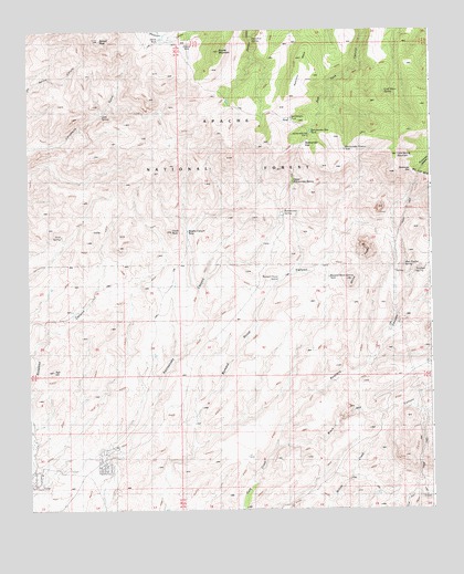
Rattlesnake Spring, AZ USGS Topographic Map
Click on map above to begin viewing in our Map Viewer.

This topographic map contains these locations and features:
Feature Name Type Latitude Longitude GNIS ID View Map
Black Jack CanyonValleyN33.0170°W109.1712°26397View Map
Brushy Canyon TankReservoirN33.0727°W109.2007°39927View Map
Brushy MountainSummitN33.1195°W109.1898°26833View Map
Brushy Mountain TankReservoirN33.1170°W109.1997°41820View Map
BUckhorn TankReservoirN33.1057°W109.1556°41821View Map
Buzzard Roost SpringSpringN33.0595°W109.1729°27113View Map
Buzzard Roost TankReservoirN33.0604°W109.1569°39934View Map
Cave SpringSpringN33.1032°W109.2269°40555View Map
Chalk PeakSummitN33.0726°W109.2051°27484View Map
Cold Spring MountainSummitN33.0926°W109.1351°27801View Map
Cold Spring Mountain TankReservoirN33.1025°W109.1448°41822View Map
Cold Water SpringSpringN33.1088°W109.1393°27804View Map
Corner TankReservoirN33.1234°W109.1517°39952View Map
Deer Basin SpringSpringN33.0743°W109.1464°1853744View Map
Fence TankReservoirN33.1229°W109.2085°39975View Map
Frank Davis RanchLocaleN33.0276°W109.1965°39981View Map
Gap Holding CorralLocaleN33.0967°W109.1653°41815View Map
Gayle TankReservoirN33.1211°W109.2011°39985View Map
Gold SpringSpringN33.0715°W109.2398°29390View Map
Hamilton MesaSummitN33.1176°W109.1645°29706View Map
Hamilton SpringSpringN33.1224°W109.1803°29708View Map
High Mesa TankReservoirN33.0984°W109.2206°41817View Map
Lambing Camp TankReservoirN33.1064°W109.1879°41819View Map
Lyda CreekStreamN33.0167°W109.1737°42778View Map
Phillips RanchLocaleN33.0131°W109.2248°40054View Map
Rattlesnake GapGapN33.0940°W109.1598°40063View Map
Rattlesnake Gap CampLocaleN33.0981°W109.1620°40554View Map
Rattlesnake Gap CampLocaleN33.0984°W109.1617°40064View Map
Rattlesnake Gap TankReservoirN33.0985°W109.1622°41816View Map
Rattlesnake Pasture TankReservoirN33.0939°W109.1517°40066View Map
Rattlesnake SpringSpringN33.0774°W109.1708°44646View Map
Rattlesnake TankReservoirN33.1018°W109.1689°40068View Map
Rattlesnake Tanks Number TwoReservoirN33.1017°W109.1701°41814View Map
Red HillSummitN33.0362°W109.2423°33444View Map
Rustlers CanyonValleyN33.0167°W109.1756°33887View Map
Rustlers SpringSpringN33.0617°W109.1301°33888View Map
Silver Basin CorralLocaleN33.1042°W109.2095°41818View Map
Silver Basin TankReservoirN33.0952°W109.2058°41824View Map
Sixshooter GapGapN33.0884°W109.1301°34477View Map
Soapbox CanyonValleyN33.0145°W109.2495°34599View Map
Sunset PeakSummitN33.1226°W109.2265°34975View Map
Upper Rattlesnake SpringSpringN33.0856°W109.1678°35708View Map
West Brushy Canyon TankReservoirN33.0784°W109.2301°40129View Map
West Rustler SpringSpringN33.0638°W109.1336°40534View Map
West Rustlers SpringSpringN33.0616°W109.1337°40131View Map
White PeaksSummitN33.0681°W109.1445°36099View Map
White Peaks TankReservoirN33.0657°W109.1561°1853743View Map
Woods Canyon TankReservoirN33.0766°W109.2224°1853745View Map

Note: Coordinates in the location and feature list above are referenced to NAD83 datum.


Copyright (C) 2008-2025 Ryan Niemi / Sunset Dynamics ... All Rights Reserved