TopoQuest Logo
Do you find TopoQuest useful?
Help keep TopoQuest running and adding new maps/features by donating!
Bitcoin:  19c7KJd3qBynnjoSw5npx9KScwjBe4ifkT
Litecoin:  LXs6TkuXGGXo1vDsWCkWVdjQX94eUKd6ui
Home View Maps Find Maps Find Places Resources & Links


Red Knoll, Arizona Topographic Map

USGS Map Title: Red Knoll, AZ
USGS Map MRC: 34110E5
DRG (GeoTIFF) Download: o34110e5.tif


Neighboring USGS Topographic Map Quads:


  Potato Wash North, AZ  
34110F6
 

  Potato Wash NE, AZ  
34110F5
 

  Dry Lake NW, AZ  
34110F4
 

  Potato Wash South, AZ  
34110E6
 

  Red Knoll, AZ  
34110E5
 

  Zeniff, AZ  
34110E4
 

  Hanks Draw, AZ  
34110D6
 

  Heber, AZ  
34110D5
 

  Aripine, AZ  
34110D4


Map MRC Location:

N35°
W111°
N35°
W110°
H8 H7 H6 H5 H4 H3 H2 H1
G8 G7 G6 G5 G4 G3 G2 G1
F8 F7 F6 F5 F4 F3 F2 F1
E8 E7 E6 E5 E4 E3 E2 E1
D8 D7 D6 D5 D4 D3 D2 D1
C8 C7 C6 C5 C4 C3 C2 C1
B8 B7 B6 B5 B4 B3 B2 B1
A8 A7 A6 A5 A4 A3 A2 A1
N34°
W111°
N34°
W110°

Red Knoll, AZ USGS 1:24K Topographic Map Preview:
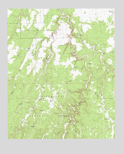
Red Knoll, AZ USGS Topographic Map
Click on map above to begin viewing in our Map Viewer.

This topographic map contains these locations and features:
Feature Name Type Latitude Longitude GNIS ID View Map
Ancient TankReservoirN34.5074°W110.5267°25642View Map
Brookbank CanyonValleyN34.6173°W110.5646°26771View Map
Cement Dam TankReservoirN34.5687°W110.5481°27455View Map
E S TankReservoirN34.5877°W110.5257°28717View Map
East Fork Larson DrawValleyN34.5861°W110.5918°28758View Map
Gardner TankReservoirN34.5495°W110.5732°42005View Map
Larson DrawValleyN34.5981°W110.5735°30890View Map
Larson TankReservoirN34.6043°W110.5887°30892View Map
Limestone TankReservoirN34.5404°W110.5537°42004View Map
Long DrawValleyN34.5653°W110.5079°31236View Map
Long Hollow DrawValleyN34.5300°W110.5168°41534View Map
Lower Long Draw TankReservoirN34.5195°W110.5068°31366View Map
Lower Trick TankReservoirN34.5234°W110.5001°40211View Map
Middle Fork Larson DrawValleyN34.5595°W110.6160°31807View Map
North Trick TankReservoirN34.5261°W110.5004°42010View Map
Petes TankReservoirN34.5751°W110.5795°32838View Map
Pierce WashStreamN34.6003°W110.5512°32882View Map
Pierce Wash TankReservoirN34.5994°W110.5427°32884View Map
Poyer TankReservoirN34.6224°W110.5029°33180View Map
Red KnollSummitN34.5275°W110.5873°33467View Map
Red Knoll FlatFlatN34.5389°W110.5757°33469View Map
Red Knoll Flat TankReservoirN34.5364°W110.5768°33470View Map
Red Knoll TankReservoirN34.5376°W110.5902°33471View Map
Red Knoll WellWellN34.5445°W110.5673°33472View Map
Red Water TankReservoirN34.5239°W110.5891°41997View Map
Section Eleven TankReservoirN34.5309°W110.5168°34200View Map
Section Thirty-three TankReservoirN34.5556°W110.5545°34225View Map
Section Twentyone TankReservoirN34.5071°W110.5479°34216View Map
Solomon ButteSummitN34.5723°W110.5285°34633View Map
Squaw TankReservoirN34.5858°W110.5993°34786View Map
Squaw Tank SouthReservoirN34.5855°W110.6001°42003View Map
Stolen Tank Number TwoReservoirN34.5115°W110.5947°34864View Map
Turley TankReservoirN34.5818°W110.5149°35587View Map
Uranium TankReservoirN34.5438°W110.5248°35736View Map
West Indian TankReservoirN34.5339°W110.6084°36000View Map

Note: Coordinates in the location and feature list above are referenced to NAD83 datum.


Copyright (C) 2008-2024 Ryan Niemi / Sunset Dynamics ... All Rights Reserved