TopoQuest Logo
Do you find TopoQuest useful?
Help keep TopoQuest running and adding new maps/features by donating!
Bitcoin:  19c7KJd3qBynnjoSw5npx9KScwjBe4ifkT
Litecoin:  LXs6TkuXGGXo1vDsWCkWVdjQX94eUKd6ui
Home View Maps Find Maps Find Places Resources & Links


Zeniff, Arizona Topographic Map

USGS Map Title: Zeniff, AZ
USGS Map MRC: 34110E4
DRG (GeoTIFF) Download: o34110e4.tif


Neighboring USGS Topographic Map Quads:


  Potato Wash NE, AZ  
34110F5
 

  Dry Lake NW, AZ  
34110F4
 

  Dry Lake NE, AZ  
34110F3
 

  Red Knoll, AZ  
34110E5
 

  Zeniff, AZ  
34110E4
 

  Sheepskin Wash, AZ  
34110E3
 

  Heber, AZ  
34110D5
 

  Aripine, AZ  
34110D4
 

  Big Pug Tank, AZ  
34110D3


Map MRC Location:

N35°
W111°
N35°
W110°
H8 H7 H6 H5 H4 H3 H2 H1
G8 G7 G6 G5 G4 G3 G2 G1
F8 F7 F6 F5 F4 F3 F2 F1
E8 E7 E6 E5 E4 E3 E2 E1
D8 D7 D6 D5 D4 D3 D2 D1
C8 C7 C6 C5 C4 C3 C2 C1
B8 B7 B6 B5 B4 B3 B2 B1
A8 A7 A6 A5 A4 A3 A2 A1
N34°
W111°
N34°
W110°

Zeniff, AZ USGS 1:24K Topographic Map Preview:
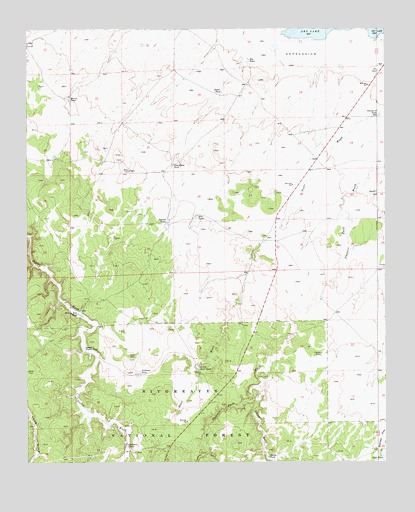
Zeniff, AZ USGS Topographic Map
Click on map above to begin viewing in our Map Viewer.

This topographic map contains these locations and features:
Feature Name Type Latitude Longitude GNIS ID View Map
Big TankReservoirN34.6160°W110.4231°26307View Map
Bigler TankReservoirN34.6063°W110.4331°26318View Map
Charlie Ross TankReservoirN34.5428°W110.4825°27518View Map
Corner Number Two TankReservoirN34.5113°W110.3975°42012View Map
Corner TankReservoirN34.5305°W110.3981°27951View Map
Decker WashStreamN34.5214°W110.4193°28359View Map
DeSpain TankReservoirN34.5050°W110.4659°28315View Map
Homestead TankReservoirN34.5855°W110.4499°30084View Map
Little Scott TankReservoirN34.5275°W110.4410°31123View Map
Lower Pierce TankReservoirN34.5324°W110.4806°31373View Map
Morris TankReservoirN34.6049°W110.4857°32061View Map
New TankReservoirN34.5707°W110.4413°32300View Map
Purcell TankReservoirN34.5692°W110.4514°33234View Map
Scott TankReservoirN34.5026°W110.3766°42013View Map
Scott WashStreamN34.6006°W110.3776°34169View Map
Scott WellWellN34.5139°W110.4473°42011View Map
Section Eighteen TankReservoirN34.6006°W110.3775°34211View Map
Sinkhole TankReservoirN34.5253°W110.4620°34464View Map
Smith TankReservoirN34.5012°W110.4169°34564View Map
ZeniffPopulated PlaceN34.5773°W110.3782°36502View Map

Note: Coordinates in the location and feature list above are referenced to NAD83 datum.


Copyright (C) 2008-2024 Ryan Niemi / Sunset Dynamics ... All Rights Reserved