TopoQuest Logo
Do you find TopoQuest useful?
Help keep TopoQuest running and adding new maps/features by donating!
Bitcoin:  19c7KJd3qBynnjoSw5npx9KScwjBe4ifkT
Litecoin:  LXs6TkuXGGXo1vDsWCkWVdjQX94eUKd6ui
Home View Maps Find Maps Find Places Resources & Links


Red Oak, North Carolina Topographic Map

USGS Map Title: Red Oak, NC
USGS Map MRC: 36077A8
DRG (GeoTIFF) Download: o36077a8.tif


Neighboring USGS Topographic Map Quads:


  Centerville, NC  
36078B1
 

  Essex, NC  
36077B8
 

  Ringwood, NC  
36077B7
 

  Castalia, NC  
36078A1
 

  Red Oak, NC  
36077A8
 

  Drake, NC  
36077A7
 

  Spring Hope, NC  
35078H1
 

  Nashville, NC  
35077H8
 

  Rocky Mount, NC  
35077H7


Map MRC Location:

N37°
W78°
N37°
W77°
H8 H7 H6 H5 H4 H3 H2 H1
G8 G7 G6 G5 G4 G3 G2 G1
F8 F7 F6 F5 F4 F3 F2 F1
E8 E7 E6 E5 E4 E3 E2 E1
D8 D7 D6 D5 D4 D3 D2 D1
C8 C7 C6 C5 C4 C3 C2 C1
B8 B7 B6 B5 B4 B3 B2 B1
A8 A7 A6 A5 A4 A3 A2 A1
N36°
W78°
N36°
W77°

Red Oak, NC USGS 1:24K Topographic Map Preview:
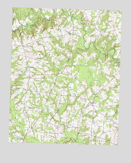
Red Oak, NC USGS Topographic Map
Click on map above to begin viewing in our Map Viewer.

This topographic map contains these locations and features:
Feature Name Type Latitude Longitude GNIS ID View Map
Adams CemeteryCemeteryN36.0240°W77.9789°980037View Map
Arrington CemeteryCemeteryN36.0832°W77.9358°980290View Map
Beulah ChurchChurchN36.0099°W77.9530°981276View Map
Boseman CemeteryCemeteryN36.0915°W77.9697°981747View Map
Capps CemeteryCemeteryN36.0199°W77.9202°982641View Map
Capps CemeteryCemeteryN36.0158°W77.9271°2779123View Map
Castalia Volunteer Fire DepartmentBuildingN36.0905°W77.9906°2638273View Map
Cedar Grove SchoolSchoolN36.0785°W77.9689°982858View Map
Coley CemeteryCemeteryN36.0050°W77.8803°983369View Map
Collins PondReservoirN36.0218°W77.9247°999917View Map
Collins Pond DamDamN36.0218°W77.9247°999916View Map
Coopers BridgeBridgeN36.1243°W77.9528°1951126View Map
Coopers PondReservoirN36.1053°W77.9441°1000080View Map
Coopers Pond DamDamN36.1052°W77.9447°1000081View Map
Cyrus Store (historical)LocaleN36.1077°W77.9294°1951130View Map
Double S AirportAirportN36.0645°W77.9236°2679245View Map
Drakes BridgeBridgeN36.1057°W77.9930°1006917View Map
DukesPopulated PlaceN36.0599°W77.9780°1006185View Map
Ellens Store (historical)LocaleN36.0615°W77.8830°1951135View Map
Enroughty CemeteryCemeteryN36.0096°W77.9519°984811View Map
Evans School (historical)SchoolN36.0232°W77.9664°1951137View Map
Gideon SwampStreamN36.1249°W77.9528°985679View Map
Green CemeteryCemeteryN36.1229°W77.8791°986047View Map
Griffin CemeteryCemeteryN36.0104°W77.9555°986151View Map
Griffin CemeteryCemeteryN36.0429°W77.9275°986152View Map
Griffin CemeteryCemeteryN36.0471°W77.9280°986153View Map
Griffin CemeteryCemeteryN36.0501°W77.9397°986154View Map
Grossetts Store (historical)LocaleN36.0974°W77.9650°1951141View Map
Hales CemeteryCemeteryN36.0513°W77.9005°986292View Map
Hedgepeth CemeteryCemeteryN36.0357°W77.9861°986592View Map
Hillardston School (historical)SchoolN36.0960°W77.9689°1951147View Map
Hillardston School (historical)SchoolN36.0993°W77.9464°1951148View Map
Hilliard CemeteryCemeteryN36.0513°W77.8830°986815View Map
Hilliard CemeteryCemeteryN36.0788°W77.8900°986816View Map
Hilliards Store (historical)LocaleN36.0524°W77.8825°1951150View Map
HilliardstonPopulated PlaceN36.1054°W77.9297°1020779View Map
Hunt CemeteryCemeteryN36.0101°W77.9166°987246View Map
Jones CemeteryCemeteryN36.0493°W77.9794°987725View Map
Jones CemeteryCemeteryN36.0526°W77.9483°987726View Map
Jones CemeteryCemeteryN36.0649°W77.9319°987727View Map
Leonard CemeteryCemeteryN36.0579°W77.9644°988358View Map
May CemeteryCemeteryN36.0200°W77.9021°989498View Map
Philadelphia ChurchChurchN36.0627°W77.9900°992129View Map
Philadelphia ChurchChurchN36.0696°W77.9783°992130View Map
Philadelphia School (historical)SchoolN36.0702°W77.9786°1951206View Map
Philadelphia School (historical)SchoolN36.0804°W77.9686°1951207View Map
Red OakPopulated PlaceN36.0385°W77.9064°1022197View Map
Red Oak CemeteryCemeteryN36.0315°W77.9008°993127View Map
Red Oak District Volunteer Fire DepartmentBuildingN36.0392°W77.9077°2639137View Map
Red Oak Elementary SchoolSchoolN36.0396°W77.9044°1006930View Map
Red Oak Post OfficePost OfficeN36.0388°W77.9071°2774237View Map
Redland School (historical)SchoolN36.0688°W77.8758°1951214View Map
Rose CemeteryCemeteryN36.0146°W77.9466°993690View Map
Saint Delight ChurchChurchN36.0468°W77.9019°993881View Map
Saint Johns CemeteryCemeteryN36.0740°W77.8803°993926View Map
Saint Johns ChurchChurchN36.0452°W77.9019°993962View Map
Sandy CreekStreamN36.1249°W77.9525°1024288View Map
Social Union ChurchChurchN36.1052°W77.9469°995090View Map
Suttons StoreLocaleN36.0468°W77.9544°1006918View Map
Swift Creek SchoolSchoolN36.1068°W77.8978°995788View Map
Taylor CemeteryCemeteryN36.0921°W77.9742°995885View Map
Taylors School (historical)SchoolN36.0340°W77.9833°1951235View Map
Taylors StorePopulated PlaceN36.0899°W77.9872°1022895View Map
Taylors Store (historical)LocaleN36.0346°W77.9830°1951237View Map
Town of Red OakCivilN36.0415°W77.9064°2407186View Map
Township of GriffinsCivilN36.1223°W77.9688°1026982View Map
Township of Red OakCivilN36.0444°W77.9071°1026988View Map
Vaughan CemeteryCemeteryN36.0643°W77.8803°996598View Map
Vick CemeteryCemeteryN36.0882°W77.9947°996612View Map
Walker CemeteryCemeteryN36.0065°W77.9989°996696View Map
Wards Store (historical)LocaleN36.1065°W77.8830°1951243View Map
Whitfield CemeteryCemeteryN36.0180°W77.8967°997261View Map
Whitley CemeteryCemeteryN36.0401°W77.8811°997265View Map
Wood CemeteryCemeteryN36.0618°W77.9797°997564View Map
York ChapelChurchN36.1021°W77.9344°997723View Map

Note: Coordinates in the location and feature list above are referenced to NAD83 datum.


Copyright (C) 2008-2024 Ryan Niemi / Sunset Dynamics ... All Rights Reserved