TopoQuest Logo
Do you find TopoQuest useful?
Help keep TopoQuest running and adding new maps/features by donating!
Bitcoin:  19c7KJd3qBynnjoSw5npx9KScwjBe4ifkT
Litecoin:  LXs6TkuXGGXo1vDsWCkWVdjQX94eUKd6ui
Home View Maps Find Maps Find Places Resources & Links


Drake, North Carolina Topographic Map

USGS Map Title: Drake, NC
USGS Map MRC: 36077A7
DRG (GeoTIFF) Download: o36077a7.tif


Neighboring USGS Topographic Map Quads:


  Essex, NC  
36077B8
 

  Ringwood, NC  
36077B7
 

  Enfield, NC  
36077B6
 

  Red Oak, NC  
36077A8
 

  Drake, NC  
36077A7
 

  Whitakers, NC  
36077A6
 

  Nashville, NC  
35077H8
 

  Rocky Mount, NC  
35077H7
 

  Hartsease, NC  
35077H6


Map MRC Location:

N37°
W78°
N37°
W77°
H8 H7 H6 H5 H4 H3 H2 H1
G8 G7 G6 G5 G4 G3 G2 G1
F8 F7 F6 F5 F4 F3 F2 F1
E8 E7 E6 E5 E4 E3 E2 E1
D8 D7 D6 D5 D4 D3 D2 D1
C8 C7 C6 C5 C4 C3 C2 C1
B8 B7 B6 B5 B4 B3 B2 B1
A8 A7 A6 A5 A4 A3 A2 A1
N36°
W78°
N36°
W77°

Drake, NC USGS 1:24K Topographic Map Preview:
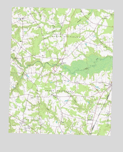
Drake, NC USGS Topographic Map
Click on map above to begin viewing in our Map Viewer.

This topographic map contains these locations and features:
Feature Name Type Latitude Longitude GNIS ID View Map
Battleboro CemeteryCemeteryN36.0443°W77.7501°2779129View Map
Battleboro Post OfficePost OfficeN36.0495°W77.7502°2773787View Map
Battleboro Rural Fire DepartmentBuildingN36.0485°W77.7529°2639380View Map
BelmontLocaleN36.0246°W77.7694°1006920View Map
Black SwampStreamN36.1071°W77.8147°981545View Map
Brake CemeteryCemeteryN36.0036°W77.8525°981819View Map
Braswell CemeteryCemeteryN36.0529°W77.8066°981840View Map
Braswell Lake DamDamN36.0468°W77.7664°999976View Map
Braswells LakeReservoirN36.0482°W77.7682°999975View Map
Brown CemeteryCemeteryN36.0099°W77.8354°982005View Map
Davis CemeteryCemeteryN36.0382°W77.7750°983994View Map
Dortch School (historical)SchoolN36.0088°W77.8558°1951133View Map
DortchesPopulated PlaceN36.0113°W77.8575°984273View Map
Dozier CemeteryCemeteryN36.1218°W77.8486°984322View Map
DrakePopulated PlaceN36.0382°W77.8175°984327View Map
Ellen CemeteryCemeteryN36.0271°W77.8503°984719View Map
Fenners PondReservoirN36.0328°W77.7778°999935View Map
Fenners Pond DamDamN36.0318°W77.7764°999934View Map
Flat Rock BranchStreamN36.0652°W77.8569°985178View Map
Gold RockPopulated PlaceN36.0702°W77.8130°1020466View Map
Greene CemeteryCemeteryN36.1051°W77.7889°986094View Map
Greene CemeteryCemeteryN36.1104°W77.8494°986095View Map
Harper CemeteryCemeteryN36.0524°W77.7936°986426View Map
Hilliards Grove ChurchChurchN36.0935°W77.8119°1006922View Map
Hornes Mill (historical)LocaleN36.0993°W77.7791°1006923View Map
Hubbard SchoolSchoolN36.0382°W77.8214°987201View Map
Johnson CemeteryCemeteryN36.0815°W77.8714°987663View Map
Manns CemeteryCemeteryN36.0776°W77.8369°989283View Map
Manns ChapelChurchN36.0913°W77.8616°989285View Map
McTyeire ChurchChurchN36.0746°W77.8116°989656View Map
New Hope ChurchChurchN36.0393°W77.8239°991016View Map
North Carolina State Highway Patrol Troop C District 1BuildingN36.0018°W77.7740°2131031View Map
North Carolina Wesleyan CollegeSchoolN36.0188°W77.7741°991204View Map
North Whitakers SchoolSchoolN36.1160°W77.7633°991279View Map
Pine Log BranchStreamN36.1040°W77.8122°992268View Map
Powell CemeteryCemeteryN36.0990°W77.8189°992769View Map
Powell CemeteryCemeteryN36.1054°W77.8244°992770View Map
Powell School (historical)SchoolN36.0993°W77.8136°1951210View Map
Red Oak District Volunteer Fire DepartmentBuildingN36.0081°W77.8539°2639584View Map
Ricks PlaceLocaleN36.0077°W77.8122°1951216View Map
Robinson CemeteryCemeteryN36.0354°W77.8483°993467View Map
Rocky Mount Fire Department Station 4BuildingN36.0045°W77.7871°2638530View Map
Rocky Mount Fire Department Station 7BuildingN36.0482°W77.7707°2638254View Map
Rocky Mount Memorial CemeteryCemeteryN36.0065°W77.8500°993607View Map
SalemPopulated PlaceN36.1146°W77.8614°1015173View Map
Salem ChurchChurchN36.1140°W77.8641°1006921View Map
Salem District Volunteer Fire DepartmentBuildingN36.1136°W77.8623°2639356View Map
Salem School (historical)SchoolN36.1138°W77.8639°1951224View Map
Shady Grove School (historical)SchoolN36.1063°W77.8397°1951225View Map
Shiloh ChurchChurchN36.1221°W77.7894°994709View Map
Shiloh School (historical)SchoolN36.1218°W77.7889°1951226View Map
Stony Creek ChurchChurchN36.0104°W77.8561°1006919View Map
Straightgate ChurchChurchN36.1060°W77.8403°995602View Map
Taylors Store (historical)LocaleN36.1104°W77.7691°1951236View Map
Town of DortchesCivilN36.0113°W77.8567°2406388View Map
Township of North WhitakersCivilN36.1096°W77.8065°1026986View Map
Township of South WhitakersCivilN36.0431°W77.8008°1026990View Map
Wadfords Store (historical)LocaleN36.1221°W77.8383°1951242View Map
Wesleyan College Post OfficePost OfficeN36.0176°W77.7744°2773883View Map
Williams CemeteryCemeteryN36.1101°W77.8130°997371View Map
Zion Cross ChurchChurchN36.1204°W77.7528°997790View Map

Note: Coordinates in the location and feature list above are referenced to NAD83 datum.


Copyright (C) 2008-2024 Ryan Niemi / Sunset Dynamics ... All Rights Reserved