TopoQuest Logo
Do you find TopoQuest useful?
Help keep TopoQuest running and adding new maps/features by donating!
Bitcoin:  19c7KJd3qBynnjoSw5npx9KScwjBe4ifkT
Litecoin:  LXs6TkuXGGXo1vDsWCkWVdjQX94eUKd6ui
Home View Maps Find Maps Find Places Resources & Links


Redland, Texas Topographic Map

USGS Map Title: Redland, TX
USGS Map MRC: 31094D6
DRG (GeoTIFF) Download: o31094d6.tif


Neighboring USGS Topographic Map Quads:


  Lake Nacogdoches South, TX  
31094E7
 

  Nacogdoches South, TX  
31094E6
 

  Woden, TX  
31094E5
 

  Clawson, TX  
31094D7
 

  Redland, TX  
31094D6
 

  Platt, TX  
31094D5
 

  Keltys, TX  
31094C7
 

  Lufkin, TX  
31094C6
 

  Huntington, TX  
31094C5


Map MRC Location:

N32°
W95°
N32°
W94°
H8 H7 H6 H5 H4 H3 H2 H1
G8 G7 G6 G5 G4 G3 G2 G1
F8 F7 F6 F5 F4 F3 F2 F1
E8 E7 E6 E5 E4 E3 E2 E1
D8 D7 D6 D5 D4 D3 D2 D1
C8 C7 C6 C5 C4 C3 C2 C1
B8 B7 B6 B5 B4 B3 B2 B1
A8 A7 A6 A5 A4 A3 A2 A1
N31°
W95°
N31°
W94°

Redland, TX USGS 1:24K Topographic Map Preview:
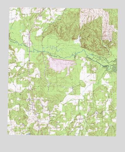
Redland, TX USGS Topographic Map
Click on map above to begin viewing in our Map Viewer.

This topographic map contains these locations and features:
Feature Name Type Latitude Longitude GNIS ID View Map
Angelina River BridgeBridgeN31.4571°W94.7263°2030652View Map
Bayou La NanaStreamN31.4593°W94.7210°1381011View Map
Bayou oa NanaStreamN31.4593°W94.7213°1383024View Map
Berry CemeteryCemeteryN31.3988°W94.6480°1381397View Map
Black BayouStreamN31.4721°W94.7210°1383033View Map
Cedar GrovePopulated PlaceN31.3849°W94.7330°1381610View Map
ClimaxPopulated PlaceN31.4888°W94.6933°1381666View Map
DavisvillePopulated PlaceN31.4030°W94.7105°1381745View Map
Davisville ChurchChurchN31.3894°W94.7013°1381746View Map
Davisville StationLocaleN31.3941°W94.7013°1381747View Map
Ellen Trout Memorial Lake DamDamN31.3752°W94.7235°1856160View Map
Gravco AirportAirportN31.3900°W94.6915°1387115View Map
Hog Pen LakeLakeN31.4518°W94.6452°1382012View Map
Just Plane Fun Airpark (historical)AirportN31.4902°W94.7147°1387235View Map
Kurth DamDamN31.4518°W94.7002°1856162View Map
Lake KurthLakeN31.4446°W94.6906°1377716View Map
Little CreekStreamN31.3869°W94.6316°1382172View Map
Little Red BranchStreamN31.4593°W94.6647°1382182View Map
Lower IslandIslandN31.4727°W94.7497°1382203View Map
Lufkin Water PlantLocaleN31.3757°W94.7247°1384608View Map
Mill CreekStreamN31.4105°W94.6691°1382299View Map
MoffittPopulated PlaceN31.3982°W94.6433°1382314View Map
Morral BayouStreamN31.4974°W94.7413°1383136View Map
Palisada SpringSpringN31.4835°W94.7252°1998417View Map
Paper Mill CreekStreamN31.4424°W94.6363°1382454View Map
Procella CemeteryCemeteryN31.4743°W94.7272°1382577View Map
Procella CreekStreamN31.4568°W94.7258°1382578View Map
Red BranchStreamN31.4577°W94.7091°1382605View Map
RedlandPopulated PlaceN31.4044°W94.7213°1382608View Map
Redland Census Designated PlaceCensusN31.4033°W94.7182°2586978View Map
River Crest EstatesPopulated PlaceN31.4260°W94.6677°2034887View Map
Rivercrest Redland Volunteer Fire Department Station 1BuildingN31.4413°W94.6559°2655602View Map
Rivercrest Redland Volunteer Fire Department Station 2BuildingN31.4066°W94.7201°2655601View Map
Saint Anns SchoolSchoolN31.4921°W94.7158°1382675View Map
Shawnee LakeLakeN31.4547°W94.6551°1382747View Map
Shawnee Mineral SpringsSpringN31.4752°W94.6585°1998418View Map
Shawnee SpringSpringN31.4624°W94.6630°1382749View Map
Tom CreekStreamN31.4263°W94.6458°1382872View Map
Venable BranchStreamN31.4502°W94.6266°1382901View Map
Walker CemeteryCemeteryN31.3963°W94.7169°1382911View Map
Willis CreekStreamN31.3946°W94.6638°1382973View Map

Note: Coordinates in the location and feature list above are referenced to NAD83 datum.


Copyright (C) 2008-2024 Ryan Niemi / Sunset Dynamics ... All Rights Reserved