TopoQuest Logo
Do you find TopoQuest useful?
Help keep TopoQuest running and adding new maps/features by donating!
Bitcoin:  19c7KJd3qBynnjoSw5npx9KScwjBe4ifkT
Litecoin:  LXs6TkuXGGXo1vDsWCkWVdjQX94eUKd6ui
Home View Maps Find Maps Find Places Resources & Links


Huntington, Texas Topographic Map

USGS Map Title: Huntington, TX
USGS Map MRC: 31094C5
DRG (GeoTIFF) Download: o31094c5.tif


Neighboring USGS Topographic Map Quads:


  Redland, TX  
31094D6
 

  Platt, TX  
31094D5
 

  Etoile North, TX  
31094D4
 

  Lufkin, TX  
31094C6
 

  Huntington, TX  
31094C5
 

  Etoile South, TX  
31094C4
 

  Bald Hill, TX  
31094B6
 

  Manning, TX  
31094B5
 

  Zavalla, TX  
31094B4


Map MRC Location:

N32°
W95°
N32°
W94°
H8 H7 H6 H5 H4 H3 H2 H1
G8 G7 G6 G5 G4 G3 G2 G1
F8 F7 F6 F5 F4 F3 F2 F1
E8 E7 E6 E5 E4 E3 E2 E1
D8 D7 D6 D5 D4 D3 D2 D1
C8 C7 C6 C5 C4 C3 C2 C1
B8 B7 B6 B5 B4 B3 B2 B1
A8 A7 A6 A5 A4 A3 A2 A1
N31°
W95°
N31°
W94°

Huntington, TX USGS 1:24K Topographic Map Preview:
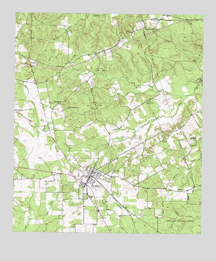
Huntington, TX USGS Topographic Map
Click on map above to begin viewing in our Map Viewer.

This topographic map contains these locations and features:
Feature Name Type Latitude Longitude GNIS ID View Map
AlcoPopulated PlaceN31.3521°W94.5705°1381297View Map
Angelina CountyCivilN31.2548°W94.6118°1383788View Map
Angelina County Constable's Office Precinct 3BuildingN31.2642°W94.5705°2751277View Map
Castleberry DamDamN31.3302°W94.5235°1856156View Map
Castleberry LakeReservoirN31.3302°W94.5235°1856157View Map
City of HuntingtonCivilN31.2804°W94.5772°2410809View Map
City of Huntington Municipal BuildingBuildingN31.2697°W94.5714°2753540View Map
Doe CreekStreamN31.2574°W94.6146°1381776View Map
DunaganPopulated PlaceN31.3466°W94.6152°1381806View Map
Dunham HillBuildingN31.2874°W94.5930°2031304View Map
Hans LakeReservoirN31.3353°W94.5735°1856155View Map
Hans Lake DamDamN31.3369°W94.5735°1856154View Map
HuntingtonPopulated PlaceN31.2777°W94.5766°1382047View Map
Huntington CemeteryCemeteryN31.2857°W94.5594°1382048View Map
Huntington Intermediate SchoolSchoolN31.2810°W94.5663°2003082View Map
Huntington Police DepartmentBuildingN31.2697°W94.5714°2751325View Map
Huntington Post OfficePost OfficeN31.2788°W94.5783°2732354View Map
Huntington Volunteer Fire DepartmentBuildingN31.2814°W94.5752°2655298View Map
Jonesville CemeteryCemeteryN31.2680°W94.5646°1382091View Map
Linston CreekStreamN31.3291°W94.5116°1382160View Map
Little Flock ChurchChurchN31.3188°W94.6235°1382177View Map
Little Hope ChurchChurchN31.3252°W94.5369°1382179View Map
McClure CemeteryCemeteryN31.3582°W94.5024°1382254View Map
Mill CreekStreamN31.3324°W94.5330°1382294View Map
Naren CemeteryCemeteryN31.3430°W94.5666°1382373View Map
Oak FlatPopulated PlaceN31.2744°W94.5146°1382407View Map
Odell ChurchChurchN31.3032°W94.5260°1382417View Map
Robinson Blue SpringsSpringN31.3044°W94.5073°1382627View Map
Rocky Hill CemeteryCemeteryN31.3649°W94.5474°1382646View Map
Rocky Hill SchoolSchoolN31.3674°W94.5374°1382647View Map
Rocky SpringsPopulated PlaceN31.3235°W94.5955°1383720View Map
Rocky Springs CemeteryCemeteryN31.3216°W94.5888°1382649View Map
Thomas CrossingPopulated PlaceN31.3721°W94.5285°1382857View Map
Traweek CemeteryCemeteryN31.3371°W94.6174°1382878View Map
Tubbs CreekStreamN31.3152°W94.5319°1382884View Map

Note: Coordinates in the location and feature list above are referenced to NAD83 datum.


Copyright (C) 2008-2025 Ryan Niemi / Sunset Dynamics ... All Rights Reserved