TopoQuest Logo
Do you find TopoQuest useful?
Help keep TopoQuest running and adding new maps/features by donating!
Bitcoin:  19c7KJd3qBynnjoSw5npx9KScwjBe4ifkT
Litecoin:  LXs6TkuXGGXo1vDsWCkWVdjQX94eUKd6ui
Home View Maps Find Maps Find Places Resources & Links


Redwood Valley, California Topographic Map

USGS Map Title: Redwood Valley, CA
USGS Map MRC: 39123C2
DRG (GeoTIFF) Download: o39123c2.tif


Neighboring USGS Topographic Map Quads:


  Willits, CA  
39123D3
 

  Foster Mountain, CA  
39123D2
 

  Van Arsdale Reservoir, CA  
39123D1
 

  Laughlin Range, CA  
39123C3
 

  Redwood Valley, CA  
39123C2
 

  Potter Valley, CA  
39123C1
 

  Orrs Springs, CA  
39123B3
 

  Ukiah, CA  
39123B2
 

  Cow Mountain, CA  
39123B1


Map MRC Location:

N40°
W124°
N40°
W123°
H8 H7 H6 H5 H4 H3 H2 H1
G8 G7 G6 G5 G4 G3 G2 G1
F8 F7 F6 F5 F4 F3 F2 F1
E8 E7 E6 E5 E4 E3 E2 E1
D8 D7 D6 D5 D4 D3 D2 D1
C8 C7 C6 C5 C4 C3 C2 C1
B8 B7 B6 B5 B4 B3 B2 B1
A8 A7 A6 A5 A4 A3 A2 A1
N39°
W124°
N39°
W123°

Redwood Valley, CA USGS 1:24K Topographic Map Preview:
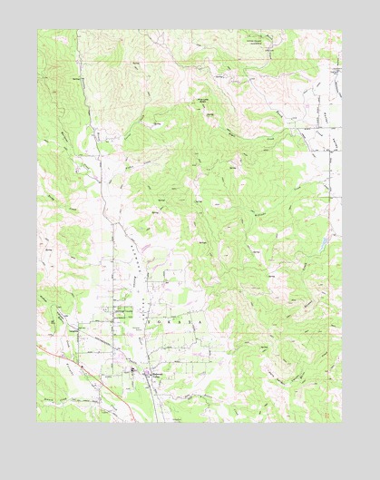
Redwood Valley, CA USGS Topographic Map
Click on map above to begin viewing in our Map Viewer.

This topographic map contains these locations and features:
Feature Name Type Latitude Longitude GNIS ID View Map
Bakers CreekStreamN39.2649°W123.2350°218559View Map
Bevans Creek 387 DamDamN39.3082°W123.1328°1663850View Map
Boyes CreekStreamN39.3463°W123.1483°219748View Map
Corral CreekStreamN39.3352°W123.2222°221582View Map
Coyote Valley ReservationCivilN39.2542°W123.2089°1985199View Map
Deep Valley Christian SchoolSchoolN39.2621°W123.2270°1724174View Map
Eagle Peak Middle SchoolSchoolN39.2675°W123.2190°2516063View Map
Fisher CreekStreamN39.3271°W123.2220°223542View Map
Fords RanchLocaleN39.3041°W123.2086°1723244View Map
Hells Delight CanyonValleyN39.2688°W123.1378°225130View Map
LaughlinPopulated PlaceN39.2796°W123.2345°252720View Map
Mariposa CreekStreamN39.3260°W123.2228°228108View Map
Mariposa RanchLocaleN39.3304°W123.2347°1723252View Map
McGee CanyonValleyN39.2804°W123.2392°228363View Map
Pine Lake BasinBasinN39.3518°W123.1861°230704View Map
Redwood ValleyValleyN39.2674°W123.2061°234554View Map
Redwood ValleyPopulated PlaceN39.2654°W123.2044°231454View Map
Redwood Valley Calpella Fire DistrictBuildingN39.2654°W123.2038°2621855View Map
Redwood Valley Census Designated PlaceCensusN39.2690°W123.2023°2628782View Map
Redwood Valley Elementary SchoolSchoolN39.2666°W123.2120°2516047View Map
Redwood Valley Middle SchoolSchoolN39.2666°W123.2117°1724245View Map
Redwood Valley Post OfficePost OfficeN39.2650°W123.2046°1724246View Map
Redwood Valley RancheriaCivilN39.2897°W123.1768°231455View Map
Redwood Valley-Potter Valley DivisionCivilN39.3025°W123.2234°1935264View Map
Rocky CreekStreamN39.3179°W123.2236°231765View Map
Salt Hollow CreekStreamN39.2532°W123.2042°232322View Map
Seward CreekStreamN39.2596°W123.2325°232831View Map
West CanalCanalN39.3552°W123.1389°268878View Map

Note: Coordinates in the location and feature list above are referenced to NAD83 datum.


Copyright (C) 2008-2025 Ryan Niemi / Sunset Dynamics ... All Rights Reserved