TopoQuest Logo
Do you find TopoQuest useful?
Help keep TopoQuest running and adding new maps/features by donating!
Bitcoin:  19c7KJd3qBynnjoSw5npx9KScwjBe4ifkT
Litecoin:  LXs6TkuXGGXo1vDsWCkWVdjQX94eUKd6ui
Home View Maps Find Maps Find Places Resources & Links


Reliance, Texas Topographic Map

USGS Map Title: Reliance, TX
USGS Map MRC: 30096F2
DRG (GeoTIFF) Download: o30096f2.tif


Neighboring USGS Topographic Map Quads:


  Kurten, TX  
30096G3
 

  Clear Lake, TX  
30096G2
 

  Iola, TX  
30096G1
 

  Bryan East, TX  
30096F3
 

  Reliance, TX  
30096F2
 

  Keith, TX  
30096F1
 

  Wellborn, TX  
30096E3
 

  Ferguson Crossing, TX  
30096E2
 

  Carlos, TX  
30096E1


Map MRC Location:

N31°
W97°
N31°
W96°
H8 H7 H6 H5 H4 H3 H2 H1
G8 G7 G6 G5 G4 G3 G2 G1
F8 F7 F6 F5 F4 F3 F2 F1
E8 E7 E6 E5 E4 E3 E2 E1
D8 D7 D6 D5 D4 D3 D2 D1
C8 C7 C6 C5 C4 C3 C2 C1
B8 B7 B6 B5 B4 B3 B2 B1
A8 A7 A6 A5 A4 A3 A2 A1
N30°
W97°
N30°
W96°

Reliance, TX USGS 1:24K Topographic Map Preview:
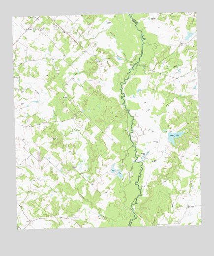
Reliance, TX USGS Topographic Map
Click on map above to begin viewing in our Map Viewer.

This topographic map contains these locations and features:
Feature Name Type Latitude Longitude GNIS ID View Map
Big SloughLakeN30.6604°W96.1789°1352133View Map
Bowman CreekStreamN30.7213°W96.1658°1352755View Map
Brazos County Precinct 3 Volunteer Fire Department Station 3BuildingN30.6367°W96.2495°2552429View Map
Brooke LakeReservoirN30.6677°W96.2344°1862840View Map
Brooke Lake DamDamN30.6652°W96.2336°1862839View Map
Brushy CreekStreamN30.6405°W96.2019°1353046View Map
Bull CreekStreamN30.6724°W96.1688°1372819View Map
Buzzard PondSwampN30.7449°W96.1867°1353453View Map
Carr LakeReservoirN30.6775°W96.1421°1353857View Map
Carr Lake DamDamN30.6802°W96.1452°1860317View Map
Channey CrossingPopulated PlaceN30.7205°W96.1677°1379533View Map
Flat PondLakeN30.6547°W96.1811°1357436View Map
Goon Fishhole SloughGutN30.6577°W96.1725°1358174View Map
Jones CreekStreamN30.6871°W96.1555°1360393View Map
K Ranch AirportAirportN30.7308°W96.1344°1386941View Map
K-Ranch LakeReservoirN30.7365°W96.1303°1860316View Map
K-Ranch Lake DamDamN30.7352°W96.1336°1860315View Map
KTSR-FM (College Station)TowerN30.6680°W96.1927°1387924View Map
Martin Prairie ChurchChurchN30.6358°W96.1344°1362224View Map
ReliancePopulated PlaceN30.7433°W96.2391°1380433View Map
Steep Hollow BranchStreamN30.7077°W96.2444°1369161View Map
Stewart LakeLakeN30.6665°W96.1630°1369191View Map
Stick CemeteryCemeteryN30.6605°W96.2111°1369196View Map

Note: Coordinates in the location and feature list above are referenced to NAD83 datum.


Copyright (C) 2008-2025 Ryan Niemi / Sunset Dynamics ... All Rights Reserved