TopoQuest Logo
Do you find TopoQuest useful?
Help keep TopoQuest running and adding new maps/features by donating!
Bitcoin:  19c7KJd3qBynnjoSw5npx9KScwjBe4ifkT
Litecoin:  LXs6TkuXGGXo1vDsWCkWVdjQX94eUKd6ui
Home View Maps Find Maps Find Places Resources & Links


Carlos, Texas Topographic Map

USGS Map Title: Carlos, TX
USGS Map MRC: 30096E1
DRG (GeoTIFF) Download: o30096e1.tif


Neighboring USGS Topographic Map Quads:


  Reliance, TX  
30096F2
 

  Keith, TX  
30096F1
 

  Singleton, TX  
30095F8
 

  Ferguson Crossing, TX  
30096E2
 

  Carlos, TX  
30096E1
 

  Roans Prairie, TX  
30095E8
 

  Millican, TX  
30096D2
 

  Navasota, TX  
30096D1
 

  Anderson, TX  
30095D8


Map MRC Location:

N31°
W97°
N31°
W96°
H8 H7 H6 H5 H4 H3 H2 H1
G8 G7 G6 G5 G4 G3 G2 G1
F8 F7 F6 F5 F4 F3 F2 F1
E8 E7 E6 E5 E4 E3 E2 E1
D8 D7 D6 D5 D4 D3 D2 D1
C8 C7 C6 C5 C4 C3 C2 C1
B8 B7 B6 B5 B4 B3 B2 B1
A8 A7 A6 A5 A4 A3 A2 A1
N30°
W97°
N30°
W96°

Carlos, TX USGS 1:24K Topographic Map Preview:
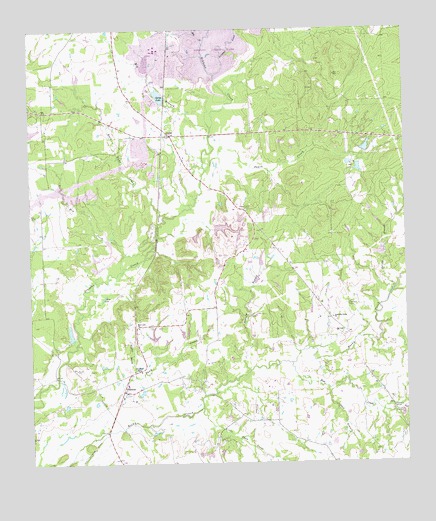
Carlos, TX USGS Topographic Map
Click on map above to begin viewing in our Map Viewer.

This topographic map contains these locations and features:
Feature Name Type Latitude Longitude GNIS ID View Map
Allen CemeteryCemeteryN30.5394°W96.0858°1350994View Map
Anderson Grove ChurchChurchN30.5419°W96.0247°1351104View Map
Big BranchStreamN30.5966°W96.0647°1352028View Map
Blue LakeLakeN30.5488°W96.1003°1352468View Map
Blue Lake ChurchChurchN30.5391°W96.0897°1352473View Map
CarlosPopulated PlaceN30.5946°W96.0780°1379507View Map
Carlos LakeReservoirN30.6058°W96.0815°1353823View Map
Carlos Lake DamDamN30.6052°W96.0802°1860307View Map
Dry CreekStreamN30.5552°W96.0955°1356299View Map
Fanthorp Inn State Historical ParkParkN30.5566°W96.0338°2031866View Map
Farm LakeReservoirN30.5908°W96.0131°1860310View Map
Farm Lake DamDamN30.5902°W96.0136°1860309View Map
Gibbons Creek DamDamN30.6102°W96.0619°1863332View Map
Hog CreekStreamN30.6208°W96.0666°1359355View Map
Jack BranchStreamN30.5216°W96.0263°1360077View Map
KBTX-TV (Bryan)TowerN30.5530°W96.0308°1386072View Map
Kennard CemeteryCemeteryN30.5452°W96.0194°1360575View Map
Little Flock CemeteryCemeteryN30.5066°W96.0616°1361358View Map
Little Flock CreekStreamN30.5163°W96.0683°1361362View Map
Moody LakeReservoirN30.5370°W96.1118°1860306View Map
Moody Lake DamDamN30.5352°W96.1119°1860305View Map
Peach CreekStreamN30.5844°W96.0661°1364922View Map
PiedmontPopulated PlaceN30.5208°W96.0947°1380354View Map
Piedmont SpringsSpringN30.5252°W96.1086°1998565View Map
Pine CreekStreamN30.5288°W96.0386°1365273View Map
Pleasant Hill CemeteryCemeteryN30.5733°W96.0536°1365423View Map
Rock Lake CreekStreamN30.5713°W96.0802°1366683View Map
Spring BranchStreamN30.5502°W96.0041°1368945View Map
Sulphur BranchStreamN30.5252°W96.0908°1369349View Map
Sulphur CreekStreamN30.6119°W96.0630°1369356View Map
Sulphur SpringsSpringN30.5274°W96.0907°1369369View Map
Tanyard BranchStreamN30.5258°W96.0536°1369604View Map
Waltrip LakeReservoirN30.5669°W96.0636°1860312View Map
Waltrip Lake DamDamN30.5669°W96.0636°1860311View Map

Note: Coordinates in the location and feature list above are referenced to NAD83 datum.


Copyright (C) 2008-2025 Ryan Niemi / Sunset Dynamics ... All Rights Reserved