TopoQuest Logo
Do you find TopoQuest useful?
Help keep TopoQuest running and adding new maps/features by donating!
Bitcoin:  19c7KJd3qBynnjoSw5npx9KScwjBe4ifkT
Litecoin:  LXs6TkuXGGXo1vDsWCkWVdjQX94eUKd6ui
Home View Maps Find Maps Find Places Resources & Links


Rhodes Peak, Arizona Topographic Map

USGS Map Title: Rhodes Peak, AZ
USGS Map MRC: 32110F4
DRG (GeoTIFF) Download: o32110f4.tif


Neighboring USGS Topographic Map Quads:


  Holy Joe Peak, AZ  
32110G5
 

  Oak Grove Canyon, AZ  
32110G4
 

  Klondyke, AZ  
32110G3
 

  Clark Ranch, AZ  
32110F5
 

  Rhodes Peak, AZ  
32110F4
 

  Kennedy Peak, AZ  
32110F3
 

  Peppersauce Wash, AZ  
32110E5
 

  Kielberg Canyon, AZ  
32110E4
 

  Bassett Peak, AZ  
32110E3


Map MRC Location:

N33°
W111°
N33°
W110°
H8 H7 H6 H5 H4 H3 H2 H1
G8 G7 G6 G5 G4 G3 G2 G1
F8 F7 F6 F5 F4 F3 F2 F1
E8 E7 E6 E5 E4 E3 E2 E1
D8 D7 D6 D5 D4 D3 D2 D1
C8 C7 C6 C5 C4 C3 C2 C1
B8 B7 B6 B5 B4 B3 B2 B1
A8 A7 A6 A5 A4 A3 A2 A1
N32°
W111°
N32°
W110°

Rhodes Peak, AZ USGS 1:24K Topographic Map Preview:
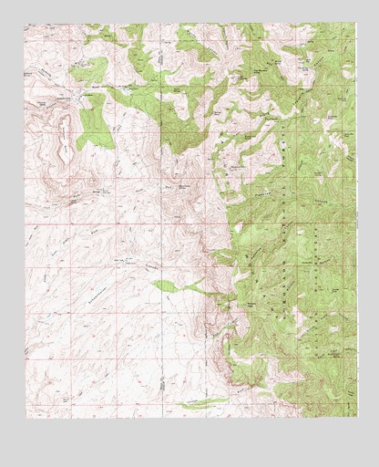
Rhodes Peak, AZ USGS Topographic Map
Click on map above to begin viewing in our Map Viewer.

This topographic map contains these locations and features:
Feature Name Type Latitude Longitude GNIS ID View Map
Biscuit PeakSummitN32.7212°W110.4293°1440View Map
Biscuit Peak SpringSpringN32.7143°W110.4173°1441View Map
Buck CanyonValleyN32.6484°W110.4334°2061View Map
Bunker Hill MineMineN32.7367°W110.4790°2197View Map
Cake MountainSummitN32.7326°W110.4212°2360View Map
Cake Mountain SpringSpringN32.7351°W110.4143°2361View Map
Cave SpringSpringN32.7201°W110.3982°22445View Map
Clark SpringSpringN32.6942°W110.4827°2979View Map
Coffee TankReservoirN32.6498°W110.3973°22458View Map
Coffee Tank DamDamN32.6500°W110.3978°2515492View Map
Crooked TankReservoirN32.6645°W110.3851°3580View Map
Field Canyon SpringSpringN32.6451°W110.3818°4581View Map
Fourmile PeakSummitN32.7195°W110.3865°4788View Map
Fourmile TankReservoirN32.7255°W110.3788°4793View Map
French GapGapN32.7373°W110.3945°4847View Map
French Gap SpringSpringN32.7357°W110.3932°4848View Map
Horse Camp SpringSpringN32.6987°W110.4421°5951View Map
Horse Mountain TankReservoirN32.7151°W110.3792°5976View Map
Juniper SpringSpringN32.7027°W110.3884°6546View Map
Magna MineMineN32.7270°W110.4787°7591View Map
Mailbox Tank DamDamN32.6711°W110.3936°2515493View Map
Mailbox WellWellN32.6737°W110.3918°7600View Map
Maverick MountainSummitN32.7040°W110.4229°7787View Map
Maverick North Fork DamDamN32.6961°W110.4267°2515557View Map
Maverick TankReservoirN32.6962°W110.4270°22568View Map
Mercer RanchLocaleN32.7292°W110.4615°7877View Map
North Fork Clark WashStreamN32.6959°W110.4723°8722View Map
Norton SpringSpringN32.7296°W110.4439°8810View Map
Peach SpringSpringN32.7245°W110.3854°22602View Map
Peepstem CanyonValleyN32.6923°W110.3856°9307View Map
Rhodes PeakSummitN32.6609°W110.4165°10240View Map
Rhodes RanchLocaleN32.6748°W110.4620°10241View Map
Scanlon SpringSpringN32.7215°W110.4895°23813View Map
Schoenholzer CanyonValleyN32.6506°W110.4870°11008View Map
Sombrero ButteSummitN32.7137°W110.4859°11547View Map
Sombrero ButtePopulated PlaceN32.7262°W110.4823°24622View Map
South Canyon TankReservoirN32.7056°W110.4248°22662View Map
South Field Canyon TankReservoirN32.6354°W110.3790°22663View Map
South Fork Clark WashStreamN32.6959°W110.4726°11594View Map
Upper Pipestem DamDamN32.6958°W110.4000°2515558View Map
Whitting SpringSpringN32.7240°W110.4918°13728View Map
Willow CreekStreamN32.7290°W110.3937°13826View Map
Willow SpringSpringN32.7370°W110.4063°13841View Map

Note: Coordinates in the location and feature list above are referenced to NAD83 datum.


Copyright (C) 2008-2024 Ryan Niemi / Sunset Dynamics ... All Rights Reserved