TopoQuest Logo
Do you find TopoQuest useful?
Help keep TopoQuest running and adding new maps/features by donating!
Bitcoin:  19c7KJd3qBynnjoSw5npx9KScwjBe4ifkT
Litecoin:  LXs6TkuXGGXo1vDsWCkWVdjQX94eUKd6ui
Home View Maps Find Maps Find Places Resources & Links


Rhodesdale, Maryland Topographic Map

USGS Map Title: Rhodesdale, MD
USGS Map MRC: 38075E7
DRG (GeoTIFF) Download: o38075e7.tif


Neighboring USGS Topographic Map Quads:


  Preston, MD  
38075F8
 

  Federalsburg, MD  
38075F7
 

  Seaford West, DE  
38075F6
 

  East New Market, MD  
38075E8
 

  Rhodesdale, MD  
38075E7
 

  Sharptown, MD  
38075E6


  Hebron, MD  
38075D6


Map MRC Location:

N39°
W76°
N39°
W75°
H8 H7 H6 H5 H4 H3 H2 H1
G8 G7 G6 G5 G4 G3 G2 G1
F8 F7 F6 F5 F4 F3 F2 F1
E8 E7 E6 E5 E4 E3 E2 E1
D8 D7 D6 D5 D4 D3 D2 D1
C8 C7 C6 C5 C4 C3 C2 C1
B8 B7 B6 B5 B4 B3 B2 B1
A8 A7 A6 A5 A4 A3 A2 A1
N38°
W76°
N38°
W75°

Rhodesdale, MD USGS 1:24K Topographic Map Preview:
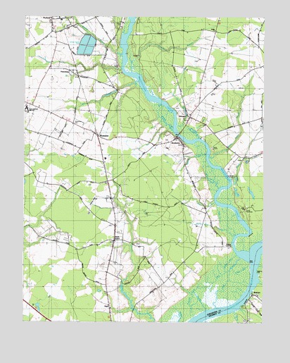
Rhodesdale, MD USGS Topographic Map
Click on map above to begin viewing in our Map Viewer.

This topographic map contains these locations and features:
Feature Name Type Latitude Longitude GNIS ID View Map
Bachelor CreekStreamN38.5798°W75.7910°582962View Map
Beach CreekStreamN38.5487°W75.7747°588600View Map
Becky Taylor BranchStreamN38.5687°W75.7785°583126View Map
Big CreekStreamN38.5265°W75.7622°588573View Map
Big Creek MarshSwampN38.5126°W75.7688°583208View Map
Big Indian CreekStreamN38.5546°W75.7733°591751View Map
Brohorn CreekStreamN38.5790°W75.7974°583423View Map
BrookviewPopulated PlaceN38.5754°W75.7960°589830View Map
Brookview Methodist ChurchChurchN38.5737°W75.7997°596447View Map
Camp ESPALocaleN38.5548°W75.7780°588580View Map
Camp NanticokeLocaleN38.5459°W75.7591°588578View Map
Chester River Country Club LakeReservoirN38.6111°W75.8416°594450View Map
Cow IslandCapeN38.5068°W75.7605°588574View Map
District 1, ForkCivilN38.5973°W75.7664°1929419View Map
District 3, ViennaCivilN38.5058°W75.8456°1929591View Map
Dorchester County Emergency Medical Services 200BuildingN38.5837°W75.7885°2639988View Map
Dukes CemeteryCemeteryN38.5595°W75.7665°588579View Map
EldoradoPopulated PlaceN38.5843°W75.7891°584269View Map
Eldorado - Brookview Volunteer Fire Company Station 26BuildingN38.5837°W75.7885°2085746View Map
Eldorado CemeteryCemeteryN38.5850°W75.7886°596516View Map
Eldorado United Methodist ChurchChurchN38.5851°W75.7883°596518View Map
Ennalls (historical)Populated PlaceN38.6007°W75.8472°588601View Map
Ennalls WharfLocaleN38.6057°W75.8247°584305View Map
Evangelical Church of GodChurchN38.5759°W75.7958°596526View Map
Fork LandingLocaleN38.5243°W75.7563°596535View Map
Fork PointCapeN38.5243°W75.7563°584453View Map
Grimes CreekStreamN38.5012°W75.7797°584771View Map
Hidden Hills AirportAirportN38.6192°W75.8395°595302View Map
Hollering PointCapeN38.5201°W75.7530°585022View Map
HurlockPopulated PlaceN38.6243°W75.8544°590523View Map
Hurlock Oxidation Ponds DamDamN38.6101°W75.8430°594449View Map
Krafts CreekStreamN38.5479°W75.7741°588583View Map
Laytons DitchCanalN38.5251°W75.7677°588581View Map
Little Indian CreekStreamN38.5540°W75.7741°585473View Map
Lone Pine CreekGutN38.5126°W75.7719°588572View Map
Marshyhope CreekStreamN38.5273°W75.7566°582839View Map
Marshyhope VillagePopulated PlaceN38.6226°W75.8238°596609View Map
McKendree CemeteryCemeteryN38.5815°W75.8489°588576View Map
Mill BranchStreamN38.5812°W75.7958°585849View Map
Mill CreekStreamN38.5984°W75.8158°585857View Map
Mission SchoolSchoolN38.6187°W75.8602°588602View Map
National Church of GodChurchN38.6240°W75.8599°596620View Map
North Dorchester High SchoolSchoolN38.5877°W75.8739°596624View Map
Owens CreekStreamN38.5046°W75.7644°586368View Map
Panguash CreekStreamN38.5021°W75.7869°588571View Map
PetersburgPopulated PlaceN38.6037°W75.8566°591000View Map
Puckum BranchStreamN38.6021°W75.8199°586720View Map
RalphPopulated PlaceN38.5071°W75.8302°591091View Map
Reconow CreekStreamN38.5234°W75.7522°1668515View Map
Red BanksBarN38.5362°W75.7566°588577View Map
Reids GrovePopulated PlaceN38.5337°W75.8274°591111View Map
Reids Grove CemeteryCemeteryN38.5331°W75.8283°596642View Map
Reids Grove United Methodist ChurchChurchN38.5332°W75.8280°596644View Map
RhodesdalePopulated PlaceN38.5762°W75.8360°586815View Map
Rhodesdale Post OfficePost OfficeN38.5773°W75.8377°596646View Map
RivertonPopulated PlaceN38.5112°W75.7544°591142View Map
Riverton United Methodist ChurchChurchN38.5112°W75.7527°1668519View Map
Rose DitchCanalN38.5218°W75.7613°588582View Map
Shiloh ChurchPopulated PlaceN38.5887°W75.8708°596689View Map
Shiloh Church (historical)ChurchN38.5882°W75.8660°588604View Map
Spears CreekStreamN38.5693°W75.7799°587487View Map
Stony Bar CreekStreamN38.5357°W75.7644°591793View Map
The CanalCanalN38.5090°W75.7844°588570View Map
Town of BrookviewCivilN38.5740°W75.7930°2390757View Map
Town of EldoradoCivilN38.5840°W75.7895°2390162View Map
Walnut LandingPopulated PlaceN38.5304°W75.7658°591488View Map
Websters SidingLocaleN38.6134°W75.8524°596735View Map
Wesley ChurchChurchN38.6196°W75.7763°588575View Map
Wheatley Camp Ground (historical)LocaleN38.6126°W75.7513°596738View Map
Wheatley School (historical)SchoolN38.6140°W75.7533°596739View Map
Wrights BranchStreamN38.6104°W75.8244°588353View Map
Zoar United Methodist ChurchChurchN38.5313°W75.8363°2503774View Map
Zorah ChurchChurchN38.6007°W75.8452°596759View Map

Note: Coordinates in the location and feature list above are referenced to NAD83 datum.


Copyright (C) 2008-2024 Ryan Niemi / Sunset Dynamics ... All Rights Reserved