TopoQuest Logo
Do you find TopoQuest useful?
Help keep TopoQuest running and adding new maps/features by donating!
Bitcoin:  19c7KJd3qBynnjoSw5npx9KScwjBe4ifkT
Litecoin:  LXs6TkuXGGXo1vDsWCkWVdjQX94eUKd6ui
Home View Maps Find Maps Find Places Resources & Links


Sharptown, Maryland Topographic Map

USGS Map Title: Sharptown, MD
USGS Map MRC: 38075E6
DRG (GeoTIFF) Download: o38075e6.tif


Neighboring USGS Topographic Map Quads:


  Federalsburg, MD  
38075F7
 

  Seaford West, DE  
38075F6
 

  Seaford East, DE  
38075F5
 

  Rhodesdale, MD  
38075E7
 

  Sharptown, MD  
38075E6
 

  Laurel, DE  
38075E5


  Hebron, MD  
38075D6
 

  Delmar, MD  
38075D5


Map MRC Location:

N39°
W76°
N39°
W75°
H8 H7 H6 H5 H4 H3 H2 H1
G8 G7 G6 G5 G4 G3 G2 G1
F8 F7 F6 F5 F4 F3 F2 F1
E8 E7 E6 E5 E4 E3 E2 E1
D8 D7 D6 D5 D4 D3 D2 D1
C8 C7 C6 C5 C4 C3 C2 C1
B8 B7 B6 B5 B4 B3 B2 B1
A8 A7 A6 A5 A4 A3 A2 A1
N38°
W76°
N38°
W75°

Sharptown, MD USGS 1:24K Topographic Map Preview:
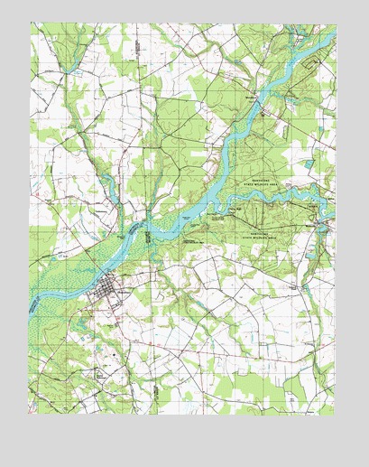
Sharptown, MD USGS Topographic Map
Click on map above to begin viewing in our Map Viewer.

This topographic map contains these locations and features:
Feature Name Type Latitude Longitude GNIS ID View Map
Asbury United Methodist ChurchChurchN38.5390°W75.7185°1668290View Map
Baileys LandingPopulated PlaceN38.5723°W75.6435°216023View Map
Barnes Woods Nature Preserve (historical)ParkN38.6196°W75.6449°217426View Map
Beaver Dam BranchStreamN38.5643°W75.6802°213614View Map
Broad CreekStreamN38.5690°W75.6747°213711View Map
Butler Mill BranchStreamN38.6157°W75.6419°213740View Map
Chapel BranchStreamN38.6204°W75.6377°213785View Map
Cherry ParkParkN38.5443°W75.7188°588976View Map
Cherry WalkLocaleN38.5654°W75.6680°213789View Map
Cod CreekStreamN38.5562°W75.6941°213810View Map
Cokesbury CemeteryCemeteryN38.6176°W75.7255°596479View Map
Cokesbury CemeteryCemeteryN38.6143°W75.7284°596480View Map
Cokesbury ChurchChurchN38.6143°W75.7285°583834View Map
Cokesbury Church (historical)ChurchN38.6176°W75.7263°589049View Map
Cokesbury School (historical)SchoolN38.6107°W75.7299°596481View Map
Cooper MillPopulated PlaceN38.5037°W75.7283°1668334View Map
Dennis CreekStreamN38.5498°W75.7163°584091View Map
District 10, SharptownCivilN38.5215°W75.7221°1929442View Map
Ellis WharfLocaleN38.5646°W75.6691°213940View Map
Gales CreekStreamN38.5571°W75.7097°584542View Map
GalestownPopulated PlaceN38.5662°W75.7149°590271View Map
Galestown MillpondReservoirN38.5676°W75.7138°584549View Map
Galestown Millpond DamDamN38.5684°W75.7147°594432View Map
Galestown United Methodist ChurchChurchN38.5659°W75.7135°588975View Map
Gum BranchStreamN38.6043°W75.6522°214044View Map
Hawks Nest ShoalsBarN38.5609°W75.6877°214065View Map
Hoagland SubdivisionPopulated PlaceN38.5671°W75.6560°215439View Map
Hurts WharfLocaleN38.5621°W75.7055°585122View Map
Irving MillpondReservoirN38.5896°W75.7299°585153View Map
Kinniken Evans DitchCanalN38.5237°W75.6549°214197View Map
Lewes CreekStreamN38.6157°W75.6399°214217View Map
Matyiko ManorPopulated PlaceN38.5015°W75.7202°1668441View Map
Messick DitchCanalN38.5768°W75.7438°585802View Map
Mill BranchStreamN38.5207°W75.6333°214311View Map
Mill CreekStreamN38.5451°W75.7222°585856View Map
Millpond AcresPopulated PlaceN38.5751°W75.7216°596610View Map
Molly Horn BranchStreamN38.5373°W75.7472°585917View Map
Mount Pleasant United Methodist ChurchChurchN38.5223°W75.6330°216338View Map
Mount Vernon ChurchChurchN38.5407°W75.7208°1668460View Map
Nanticoke Boy Scout ReservationLocaleN38.5465°W75.7380°596618View Map
Nanticoke Park Wildlife AreaParkN38.5584°W75.6580°217056View Map
Old Mill AcresPopulated PlaceN38.6048°W75.6427°215441View Map
Owens BranchStreamN38.5387°W75.6858°214421View Map
Patricks PondReservoirN38.6008°W75.6437°214429View Map
Patty Cannon EstatesPopulated PlaceN38.5929°W75.6447°215440View Map
Pevey AirportAirportN38.6144°W75.7045°2625369View Map
Phillips Landing Recreation AreaParkN38.5640°W75.6724°215333View Map
Plum CreekStreamN38.5354°W75.7460°586604View Map
PortsvillePopulated PlaceN38.5621°W75.6299°216186View Map
Portsville ChurchChurchN38.5615°W75.6285°215329View Map
Portsville MillpondReservoirN38.5593°W75.6304°214479View Map
Portsville United Methodist ChurchChurchN38.5618°W75.6285°217333View Map
Prickley Pear IslandIslandN38.5607°W75.6855°214493View Map
RalphsPopulated PlaceN38.5009°W75.6363°216189View Map
Redman CemeteryCemeteryN38.5287°W75.7135°586798View Map
River-view AcresPopulated PlaceN38.5643°W75.6338°215330View Map
Riverton AcresPopulated PlaceN38.5048°W75.7427°1668517View Map
Santo DomingoPopulated PlaceN38.5115°W75.7227°591230View Map
SharptownPopulated PlaceN38.5426°W75.7194°591265View Map
Sharptown Elementary SchoolSchoolN38.5373°W75.7216°1668544View Map
Sharptown Post OfficePost OfficeN38.5400°W75.7185°1668545View Map
Sharptown Volunteer Fire Department Station 14BuildingN38.5411°W75.7195°2087077View Map
Town of GalestownCivilN38.5633°W75.7149°2390198View Map
Town of SharptownCivilN38.5382°W75.7189°2391409View Map
Tulls School (historical)LocaleN38.6182°W75.6860°217419View Map
Turkey BranchStreamN38.5557°W75.6305°214770View Map
Turtle BranchStreamN38.6026°W75.6549°214774View Map
Tussock PondPopulated PlaceN38.5401°W75.6363°215327View Map
Tussocky BranchStreamN38.5632°W75.6296°214776View Map
Upcounty Mobile Home ParkPopulated PlaceN38.6215°W75.6408°216623View Map
WDPB-TV (Seaford)TowerN38.5346°W75.7097°215294View Map
Wheatley ChurchChurchN38.5676°W75.7413°588179View Map
Wheatley School (historical)SchoolN38.5671°W75.7419°596740View Map
Wheatleys WharfLocaleN38.5565°W75.7108°588184View Map
White River EstatesPopulated PlaceN38.5640°W75.6552°217055View Map
WMDT-TV (Salisbury)TowerN38.5018°W75.7355°598517View Map
WoodlandPopulated PlaceN38.6001°W75.6580°216257View Map
Woodland CemeteryCemeteryN38.6002°W75.6583°214878View Map
Woodland FerryLocaleN38.5993°W75.6558°214879View Map
Woodland United Methodist ChurchChurchN38.6004°W75.6591°217334View Map
Wright CreekStreamN38.5618°W75.7010°214884View Map
Wrights MillpondReservoirN38.6112°W75.7315°588354View Map
Wrights Millpond BranchStreamN38.6118°W75.7310°588355View Map
Zion ChurchChurchN38.5154°W75.7191°588377View Map
Zion Methodist CemeteryCemeteryN38.5157°W75.7200°1668617View Map

Note: Coordinates in the location and feature list above are referenced to NAD83 datum.


Copyright (C) 2008-2024 Ryan Niemi / Sunset Dynamics ... All Rights Reserved