TopoQuest Logo
Do you find TopoQuest useful?
Help keep TopoQuest running and adding new maps/features by donating!
Bitcoin:  19c7KJd3qBynnjoSw5npx9KScwjBe4ifkT
Litecoin:  LXs6TkuXGGXo1vDsWCkWVdjQX94eUKd6ui
Home View Maps Find Maps Find Places Resources & Links


Richfield Springs, New York Topographic Map

USGS Map Title: Richfield Springs, NY
USGS Map MRC: 42074G8
DRG (GeoTIFF) Download: o42074g8.tif


Neighboring USGS Topographic Map Quads:


  Millers Mills, NY  
42075H1
 

  Jordanville, NY  
42074H8
 

  Van Hornesville, NY  
42074H7
 

  Schuyler Lake, NY  
42075G1
 

  Richfield Springs, NY  
42074G8
 

  East Springfield, NY  
42074G7
 

  Hartwick, NY  
42075F1
 

  Cooperstown, NY  
42074F8
 

  Westford, NY  
42074F7


Map MRC Location:

N43°
W75°
N43°
W74°
H8 H7 H6 H5 H4 H3 H2 H1
G8 G7 G6 G5 G4 G3 G2 G1
F8 F7 F6 F5 F4 F3 F2 F1
E8 E7 E6 E5 E4 E3 E2 E1
D8 D7 D6 D5 D4 D3 D2 D1
C8 C7 C6 C5 C4 C3 C2 C1
B8 B7 B6 B5 B4 B3 B2 B1
A8 A7 A6 A5 A4 A3 A2 A1
N42°
W75°
N42°
W74°

Richfield Springs, NY USGS 1:24K Topographic Map Preview:
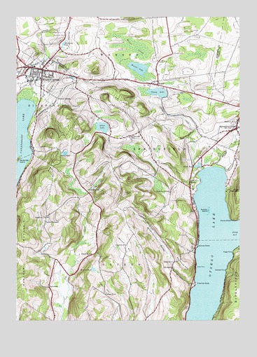
Richfield Springs, NY USGS Topographic Map
Click on map above to begin viewing in our Map Viewer.

This topographic map contains these locations and features:
Feature Name Type Latitude Longitude GNIS ID View Map
Allen LakeReservoirN42.8296°W74.9516°942360View Map
Allen Lake SchoolSchoolN42.8259°W74.9360°942361View Map
Bailey PondLakeN42.8191°W74.9726°942794View Map
Bloomfield CemeteryCemeteryN42.8676°W74.9728°944286View Map
Canadarago HillSummitN42.8490°W74.9836°2791104View Map
Capitol TheatreBuildingN42.8525°W74.9847°2380671View Map
Cary ParkParkN42.8601°W74.9890°945938View Map
Church of Christ UnitingChurchN42.8548°W74.9837°2597892View Map
Clarke PointCapeN42.7915°W74.8790°946780View Map
Clarke PondReservoirN42.8139°W74.8978°946781View Map
Cooperstown Ringwood Farms CampgroundLocaleN42.8217°W74.8930°2598949View Map
Cripple CreekStreamN42.8129°W74.8943°947751View Map
Dancing Veggie FarmLocaleN42.7986°W74.9719°2557722View Map
DeLong SchoolSchoolN42.8040°W74.9593°948107View Map
Deowongo IslandIslandN42.8162°W74.9988°948331View Map
Federal CornersLocaleN42.8415°W74.9768°949951View Map
First Presbyterian ChurchChurchN42.8547°W74.9833°2380678View Map
Fitch HillSummitN42.7656°W74.9510°950185View Map
Fitch Hill CemeteryCemeteryN42.7616°W74.9505°2558733View Map
Fivemile PointCapeN42.7651°W74.8996°950215View Map
Gladstone BuildingBuildingN42.8533°W74.9858°2380669View Map
Gravelly PointCapeN42.7706°W74.8821°951589View Map
Hayden CreekStreamN42.8134°W74.8888°952439View Map
Hoke CemeteryCemeteryN42.7853°W74.9049°952973View Map
Hutter PointCapeN42.7723°W74.8990°953549View Map
King HillSummitN42.8156°W74.9788°954635View Map
Lakeview CemeteryCemeteryN42.8453°W74.9805°954982View Map
Marshall CemeteryCemeteryN42.8600°W74.9116°956569View Map
Maumee SwampSwampN42.8609°W74.9377°956688View Map
Meadow Links Golf CourseLocaleN42.8266°W74.9252°2598955View Map
Metcalf HillSummitN42.7817°W74.9393°957032View Map
Mohegan HillSummitN42.8319°W74.9634°2788144View Map
Mohican BrookStreamN42.7648°W74.8994°2788119View Map
Mohican CanyonValleyN42.7651°W74.8999°957485View Map
Muskrat PondLakeN42.7707°W74.9565°958215View Map
Ocquionis CreekStreamN42.8409°W74.9924°959220View Map
Otsego Golf ClubLocaleN42.8141°W74.8924°2598956View Map
Otsego LakeLakeN42.7623°W74.8969°959551View Map
Panther MountainSummitN42.7706°W74.9974°970451View Map
Peggs PointCapeN42.7781°W74.8785°960102View Map
Pierce CemeteryCemeteryN42.7629°W74.9552°2558734View Map
PierstownPopulated PlaceN42.7717°W74.9127°972941View Map
Presbyterian Church CemeteryCemeteryN42.8546°W74.9836°2558732View Map
Red House HillSummitN42.7712°W74.9046°962299View Map
Richfield AirportAirportN42.8611°W74.9476°978260View Map
Richfield SpringsPopulated PlaceN42.8534°W74.9854°962471View Map
Richfield Springs Bible ChurchChurchN42.8549°W74.9843°2597907View Map
Richfield Springs Central SchoolSchoolN42.8547°W74.9897°2380675View Map
Richfield Springs Driving Park (historical)LocaleN42.8453°W74.9872°2380680View Map
Richfield Springs Post OfficePost OfficeN42.8536°W74.9884°2598933View Map
Richfield Springs Public LibraryBuildingN42.8536°W74.9889°2380673View Map
Richfield Springs Volunteer Fire DepartmentBuildingN42.8511°W74.9821°2380674View Map
Rum HillSummitN42.8029°W74.9388°963076View Map
Saint John's Episcopal ChurchChurchN42.8536°W74.9897°2380672View Map
Saint Joseph's Roman Catholic ChurchChurchN42.8503°W74.9811°2380677View Map
School Number 10 (historical)SchoolN42.7812°W74.9390°974949View Map
School Number 11 (historical)SchoolN42.7923°W74.9838°974987View Map
School Number 12 (historical)SchoolN42.7776°W74.9577°975032View Map
School Number 15 (historical)SchoolN42.7609°W74.9502°975107View Map
School Number 9 (historical)SchoolN42.7742°W74.9121°975640View Map
Sixmile PointCapeN42.7806°W74.8985°965328View Map
Springfield CenterPopulated PlaceN42.8290°W74.8765°966098View Map
Springfield Center Post OfficePost OfficeN42.8282°W74.8785°2598936View Map
Springfield Volunteer Fire Department Station 2BuildingN42.8294°W74.8764°2735172View Map
Sunken IslandIslandN42.7954°W74.8924°966799View Map
Sunset HillSummitN42.8608°W74.9886°2788142View Map
TaylortownPopulated PlaceN42.7640°W74.9815°973145View Map
Terrace HotelBuildingN42.8553°W74.9850°2380679View Map
Thurston Hill CemeteryCemeteryN42.7994°W74.9136°967493View Map
Thurston Hill SchoolSchoolN42.8029°W74.9138°967494View Map
Tiller HouseBuildingN42.8528°W74.9828°2380670View Map
Town of Richfield GarageBuildingN42.8514°W74.9833°2380676View Map
Trout BrookStreamN42.8071°W74.8958°2788141View Map
Twelve ThousandLocaleN42.7904°W74.9840°968022View Map
Twelve Thousand CemeteryCemeteryN42.7892°W74.9851°2558735View Map
Vaughns Poultry FarmLocaleN42.8681°W74.9847°2557046View Map
Village of Richfield SpringsCivilN42.8537°W74.9862°2391094View Map
Waiontha MountainSummitN42.8422°W74.9496°2788143View Map
WarrenPopulated PlaceN42.8473°W74.9210°968813View Map
Weatherby PondReservoirN42.8645°W74.9728°968959View Map
Weaver LakeLakeN42.8539°W74.9314°968966View Map
Wedderspoon HollowValleyN42.7765°W74.9149°968999View Map
Welcome Home for AdultsBuildingN42.8531°W74.9801°2598941View Map
Wilders HillSummitN42.8530°W74.9553°2791103View Map
Young LakeLakeN42.8440°W74.9207°971851View Map

Note: Coordinates in the location and feature list above are referenced to NAD83 datum.


Copyright (C) 2008-2025 Ryan Niemi / Sunset Dynamics ... All Rights Reserved