TopoQuest Logo
Do you find TopoQuest useful?
Help keep TopoQuest running and adding new maps/features by donating!
Bitcoin:  19c7KJd3qBynnjoSw5npx9KScwjBe4ifkT
Litecoin:  LXs6TkuXGGXo1vDsWCkWVdjQX94eUKd6ui
Home View Maps Find Maps Find Places Resources & Links


Millers Mills, New York Topographic Map

USGS Map Title: Millers Mills, NY
USGS Map MRC: 42075H1
DRG (GeoTIFF) Download: o42075h1.tif


Neighboring USGS Topographic Map Quads:


  Utica East, NY  
43075A2
 

  Ilion, NY  
43075A1
 

  Herkimer, NY  
43074A8
 

  West Winfield, NY  
42075H2
 

  Millers Mills, NY  
42075H1
 

  Jordanville, NY  
42074H8
 

  Unadilla Forks, NY  
42075G2
 

  Schuyler Lake, NY  
42075G1
 

  Richfield Springs, NY  
42074G8


Map MRC Location:

N43°
W76°
N43°
W75°
H8 H7 H6 H5 H4 H3 H2 H1
G8 G7 G6 G5 G4 G3 G2 G1
F8 F7 F6 F5 F4 F3 F2 F1
E8 E7 E6 E5 E4 E3 E2 E1
D8 D7 D6 D5 D4 D3 D2 D1
C8 C7 C6 C5 C4 C3 C2 C1
B8 B7 B6 B5 B4 B3 B2 B1
A8 A7 A6 A5 A4 A3 A2 A1
N42°
W76°
N42°
W75°

Millers Mills, NY USGS 1:24K Topographic Map Preview:
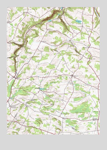
Millers Mills, NY USGS Topographic Map
Click on map above to begin viewing in our Map Viewer.

This topographic map contains these locations and features:
Feature Name Type Latitude Longitude GNIS ID View Map
Beckus GulfValleyN42.9626°W75.1040°969868View Map
Bell HillSummitN42.9731°W75.0324°943586View Map
Bloodgood SchoolSchoolN42.8909°W75.0496°944272View Map
Brown-Young CemeteryCemeteryN42.9059°W75.0977°944933View Map
Cedar Hurst Park Mobile Home ParkPopulated PlaceN42.9285°W75.1189°2598764View Map
CedarvillePopulated PlaceN42.9306°W75.1127°946160View Map
Cedarville AmbulanceBuildingN42.9318°W75.1148°2720205View Map
Cedarville CemeteryCemeteryN42.9313°W75.1183°2556883View Map
Cedarville Fire DepartmentBuildingN42.9311°W75.1139°2718652View Map
Cedarville StationPopulated PlaceN42.9028°W75.1207°946161View Map
ChepachetPopulated PlaceN42.9109°W75.1210°972315View Map
Columbia CenterPopulated PlaceN42.9326°W75.0371°947186View Map
Columbia ChurchChurchN42.9228°W75.0154°947187View Map
Cranes CornersPopulated PlaceN42.9856°W75.1238°970041View Map
Denison Corner Community ChurchChurchN42.9598°W75.0056°2598295View Map
Dennison CornersPopulated PlaceN42.9609°W75.0146°948315View Map
Dennison Corners CemeteryCemeteryN42.9608°W75.0115°2556890View Map
Edick CemeteryCemeteryN42.9658°W75.0382°949384View Map
ElizabethtownPopulated PlaceN42.9662°W75.0790°949483View Map
Fern Cliff SchoolSchoolN42.9812°W75.0232°949987View Map
Fulmer CemeteryCemeteryN42.9762°W75.0713°950791View Map
Getman CornersPopulated PlaceN42.9501°W75.0138°951051View Map
Hayner SchoolSchoolN42.9087°W75.0504°952453View Map
Helmer CemeteryCemeteryN42.9330°W75.0039°952548View Map
Holcomb GulfValleyN42.9517°W75.1149°970213View Map
Ilion GorgeValleyN42.9977°W75.0515°953588View Map
Ilion Reservoir Number OneReservoirN42.9928°W75.0553°953589View Map
Ilion Reservoir Number ThreeReservoirN42.9861°W75.0286°953591View Map
Ilion Reservoir Number TwoReservoirN42.9867°W75.0672°953590View Map
Jones HillSummitN42.9309°W75.0865°954173View Map
Joslin HillSummitN42.9998°W75.1157°954203View Map
Kinne CornersLocaleN42.9948°W75.0985°954693View Map
Leatherstocking Mobile Home ParkPopulated PlaceN42.9958°W75.0046°2598768View Map
Litchfield CemeteryCemeteryN42.9941°W75.1031°955439View Map
Maple Crest Golf CourseLocaleN42.9965°W75.0995°2598792View Map
McCoon CrossingPopulated PlaceN42.8959°W75.0515°972778View Map
Millers MillsPopulated PlaceN42.9201°W75.0815°957332View Map
Millers Mills CemeteryCemeteryN42.9172°W75.0821°2556885View Map
Millers Mills Community Baptist ChurchChurchN42.9168°W75.0824°2597774View Map
Millers Mills CrossingPopulated PlaceN42.9090°W75.0915°972802View Map
Monkey MountainSummitN42.9045°W75.0679°957525View Map
North ColumbiaPopulated PlaceN42.9778°W75.0715°958755View Map
North Columbia Church CemeteryCemeteryN42.9784°W75.0722°2556889View Map
Orendorf CornersLocaleN42.9198°W75.0021°959469View Map
Passage GulfValleyN42.9592°W75.0615°959966View Map
Peoples Undenominational ChurchChurchN42.9319°W75.1177°2597779View Map
Polly-Miller GulfValleyN42.9751°W75.0507°960868View Map
Reformed Church CemeteryCemeteryN42.9228°W75.0156°2556887View Map
Richfield HillSummitN42.9059°W75.0932°962469View Map
Richfield Hill SchoolSchoolN42.9031°W75.0988°962470View Map
School Number 1 (historical)SchoolN42.9197°W75.0025°2123437View Map
School Number 12 (historical)SchoolN42.9328°W75.0392°2123439View Map
School Number 6 (historical)SchoolN42.9847°W75.1222°2123438View Map
Schuyler CornersLocaleN42.8976°W75.0002°964630View Map
South ColumbiaPopulated PlaceN42.8892°W75.0071°965724View Map
South IlionPopulated PlaceN42.9953°W75.0490°965789View Map
SpinnervillePopulated PlaceN42.9676°W75.0402°966008View Map
Spinnerville GulfValleyN42.9976°W75.0513°966009View Map
Spoon HillSummitN42.9448°W75.0454°966028View Map
Town of ColumbiaCivilN42.9277°W75.0427°978855View Map
Unadilla LakeLakeN42.9197°W75.0779°968120View Map
Vickerman HillSummitN42.9790°W75.0149°968529View Map
Warren CemeteryCemeteryN42.9676°W75.0379°968816View Map
Wheelock PondLakeN42.9992°W75.0515°971026View Map
Youngs CrossingPopulated PlaceN42.9045°W75.0785°973308View Map

Note: Coordinates in the location and feature list above are referenced to NAD83 datum.


Copyright (C) 2008-2025 Ryan Niemi / Sunset Dynamics ... All Rights Reserved