TopoQuest Logo
Do you find TopoQuest useful?
Help keep TopoQuest running and adding new maps/features by donating!
Bitcoin:  19c7KJd3qBynnjoSw5npx9KScwjBe4ifkT
Litecoin:  LXs6TkuXGGXo1vDsWCkWVdjQX94eUKd6ui
Home View Maps Find Maps Find Places Resources & Links


Ridge Spring, South Carolina Topographic Map

USGS Map Title: Ridge Spring, SC
USGS Map MRC: 33081G6
DRG (GeoTIFF) Download: o33081g6.tif


Neighboring USGS Topographic Map Quads:


  Saluda South, SC  
33081H7
 

  Emory, SC  
33081H6
 

  Batesburg, SC  
33081H5
 

  Johnston, SC  
33081G7
 

  Ridge Spring, SC  
33081G6
 

  Monetta, SC  
33081G5
 

  Trenton, SC  
33081F7
 

  Aiken NW, SC  
33081F6
 

  Foxtown, SC  
33081F5


Map MRC Location:

N34°
W82°
N34°
W81°
H8 H7 H6 H5 H4 H3 H2 H1
G8 G7 G6 G5 G4 G3 G2 G1
F8 F7 F6 F5 F4 F3 F2 F1
E8 E7 E6 E5 E4 E3 E2 E1
D8 D7 D6 D5 D4 D3 D2 D1
C8 C7 C6 C5 C4 C3 C2 C1
B8 B7 B6 B5 B4 B3 B2 B1
A8 A7 A6 A5 A4 A3 A2 A1
N33°
W82°
N33°
W81°

Ridge Spring, SC USGS 1:24K Topographic Map Preview:
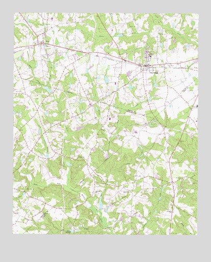
Ridge Spring, SC USGS Topographic Map
Click on map above to begin viewing in our Map Viewer.

This topographic map contains these locations and features:
Feature Name Type Latitude Longitude GNIS ID View Map
Aiken Wayside ParkParkN33.8029°W81.6373°1236209View Map
Asbill CemeteryCemeteryN33.8312°W81.6309°1220241View Map
Beech CreekStreamN33.7765°W81.7129°1220464View Map
Boatwrights PondReservoirN33.8267°W81.6577°1239057View Map
Boatwrights Pond Dam D-1157DamN33.8262°W81.6590°1239056View Map
Bog BranchStreamN33.8065°W81.7121°1220849View Map
Bulls BranchStreamN33.7504°W81.6821°1221119View Map
Clark CemeteryCemeteryN33.8115°W81.7209°1221607View Map
Coleman Ridge ChurchChurchN33.7929°W81.7029°1221680View Map
Coleman Ridge School (historical)SchoolN33.7921°W81.7015°1228917View Map
Cullums PondReservoirN33.8699°W81.7403°1239061View Map
Cullums Pond Dam D-1600DamN33.8701°W81.7415°1239060View Map
Durkes PondReservoirN33.7727°W81.7424°1237438View Map
Easter BranchStreamN33.7618°W81.6901°1222197View Map
Easter Branch CemeteryCemeteryN33.7749°W81.6701°1222198View Map
Flat Rock CemeteryCemeteryN33.8279°W81.6629°1222438View Map
Flat Rock CreekStreamN33.7826°W81.6846°1222441View Map
Herin CemeteryCemeteryN33.8262°W81.7362°1223122View Map
Holstein CemeteryCemeteryN33.8696°W81.6287°1223253View Map
Immanuel ChurchChurchN33.8429°W81.6601°1223426View Map
J C Watson PondReservoirN33.8573°W81.6499°1239073View Map
J C Watson Pond Dam D-1601DamN33.8585°W81.6498°1239072View Map
Jerusalem Baptist ChurchChurchN33.7629°W81.6423°1246168View Map
Jerusalem School (historical)SchoolN33.7640°W81.6423°1236390View Map
Jones CemeteryCemeteryN33.8496°W81.6776°1223632View Map
Long BranchStreamN33.7782°W81.7184°1224121View Map
Long Branch School (historical)SchoolN33.8046°W81.7318°1228916View Map
Lotts CreekStreamN33.7826°W81.6846°1224203View Map
Marsuella School (historical)SchoolN33.7674°W81.6401°1236420View Map
Mill CreekStreamN33.7632°W81.6912°1246660View Map
Mill Town CemeteryCemeteryN33.8637°W81.6518°1224558View Map
Morris CemeteryCemeteryN33.8307°W81.7445°1224653View Map
Mount Alford ChurchChurchN33.8479°W81.7307°1224679View Map
Mount Alford Church (historical)ChurchN33.8482°W81.7307°1232598View Map
Mount Calvary Evangelical Lutheran ChurchChurchN33.7738°W81.6937°1249549View Map
Mount Pleasant Baptist ChurchChurchN33.7813°W81.6362°1249653View Map
Peters CreekStreamN33.8729°W81.6540°1225386View Map
Pitts BranchStreamN33.8101°W81.6784°1225519View Map
R M Watsons PondReservoirN33.8352°W81.6541°1239083View Map
R M Watsons Pond D-1156 DamDamN33.8335°W81.6548°1239082View Map
Raiford CemeteryCemeteryN33.8287°W81.7004°1225738View Map
Reid LakeReservoirN33.7672°W81.6903°1239178View Map
Reid Lake Dam D-2009DamN33.7647°W81.6897°1239177View Map
Ridge Hill ChurchChurchN33.8538°W81.6568°1225875View Map
Ridge Hill High SchoolSchoolN33.8510°W81.6571°1225876View Map
Ridge SpringPopulated PlaceN33.8454°W81.6618°1250381View Map
Ridge Spring Fire Department Number 500BuildingN33.8453°W81.6605°2578614View Map
Ridge Spring Police DepartmentBuildingN33.8451°W81.6605°2734232View Map
Ridge Spring-Monetta High SchoolSchoolN33.8226°W81.6257°1236495View Map
Ridge Springs CemeteryCemeteryN33.8465°W81.6451°1250382View Map
Ridgeview LakeReservoirN33.8316°W81.7264°1238926View Map
Rutland CemeteryCemeteryN33.8090°W81.6876°1226083View Map
Sanders CemeteryCemeteryN33.7571°W81.6618°1226340View Map
Sanders PondReservoirN33.7588°W81.6580°1236523View Map
Satcher BranchStreamN33.7776°W81.7365°1226406View Map
Scott PondReservoirN33.7944°W81.7268°1237445View Map
South Carolina Noname 02063 D-2015 DamDamN33.7518°W81.7084°1238020View Map
South Carolina Noname 19013 D-0609 DamDamN33.8304°W81.7241°1238925View Map
South Carolina Noname 41008 D-1206 DamDamN33.8351°W81.6865°1239093View Map
South Carolina Noname 41010 D-1200 DamDamN33.8332°W81.6695°1239094View Map
South Carolina Noname 41012 D-1205 DamDamN33.8635°W81.6765°1239096View Map
Spann BranchStreamN33.8335°W81.7265°1226779View Map
Spann ChurchChurchN33.8565°W81.7279°1250980View Map
Titan Peach FarmsLocaleN33.8267°W81.6997°2652456View Map
Town of Ridge SpringCivilN33.8453°W81.6617°2407212View Map
Town of WardCivilN33.8573°W81.7313°2406830View Map
WardPopulated PlaceN33.8579°W81.7298°1251321View Map
Ward Baptist ChurchChurchN33.8596°W81.7340°1232645View Map
Watson CemeteryCemeteryN33.8676°W81.6715°1227439View Map
Wimbley Branch School (historical)SchoolN33.8107°W81.6898°1252032View Map
Yonce MillpondReservoirN33.7520°W81.7100°1251529View Map

Note: Coordinates in the location and feature list above are referenced to NAD83 datum.


Copyright (C) 2008-2024 Ryan Niemi / Sunset Dynamics ... All Rights Reserved