TopoQuest Logo
Do you find TopoQuest useful?
Help keep TopoQuest running and adding new maps/features by donating!
Bitcoin:  19c7KJd3qBynnjoSw5npx9KScwjBe4ifkT
Litecoin:  LXs6TkuXGGXo1vDsWCkWVdjQX94eUKd6ui
Home View Maps Find Maps Find Places Resources & Links


Rienzi, Mississippi Topographic Map

USGS Map Title: Rienzi, MS
USGS Map MRC: 34088G5
DRG (GeoTIFF) Download: o34088g5.tif


Neighboring USGS Topographic Map Quads:


  Kossuth North, MS  
34088H6
 

  Corinth, MS  
34088H5
 

  Kendrick, MS  
34088H4
 

  Kossuth South, MS  
34088G6
 

  Rienzi, MS  
34088G5
 

  Glens, MS  
34088G4
 

  Jumpertown, MS  
34088F6
 

  Booneville, MS  
34088F5
 

  Altitude, MS  
34088F4


Map MRC Location:

N35°
W89°
N35°
W88°
H8 H7 H6 H5 H4 H3 H2 H1
G8 G7 G6 G5 G4 G3 G2 G1
F8 F7 F6 F5 F4 F3 F2 F1
E8 E7 E6 E5 E4 E3 E2 E1
D8 D7 D6 D5 D4 D3 D2 D1
C8 C7 C6 C5 C4 C3 C2 C1
B8 B7 B6 B5 B4 B3 B2 B1
A8 A7 A6 A5 A4 A3 A2 A1
N34°
W89°
N34°
W88°

Rienzi, MS USGS 1:24K Topographic Map Preview:
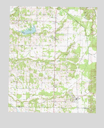
Rienzi, MS USGS Topographic Map
Click on map above to begin viewing in our Map Viewer.

This topographic map contains these locations and features:
Feature Name Type Latitude Longitude GNIS ID View Map
AllentownPopulated PlaceN34.8573°W88.6051°666221View Map
Anyola School (historical)SchoolN34.8701°W88.5678°706830View Map
Benjimen Lake DamDamN34.7751°W88.5367°682799View Map
Bethel School (historical)SchoolN34.7993°W88.5462°684658View Map
Bethel United Methodist ChurchChurchN34.8068°W88.5603°666959View Map
BiggersvillePopulated PlaceN34.8356°W88.5587°667160View Map
Biggersville ChurchChurchN34.8298°W88.5673°684662View Map
Biggersville Elementary SchoolSchoolN34.8384°W88.5606°706831View Map
Biggersville First Baptist ChurchChurchN34.8565°W88.5598°684661View Map
Biggersville High SchoolSchoolN34.8381°W88.5598°706833View Map
Biggersville Volunteer Fire DepartmentBuildingN34.8361°W88.5610°2665941View Map
Bynum CreekStreamN34.7801°W88.5395°667881View Map
Camp WarrinerLocaleN34.8684°W88.5156°684667View Map
Church of ChristChurchN34.8434°W88.5589°684669View Map
Clear CreekStreamN34.8418°W88.5153°668566View Map
Danville (historical)LocaleN34.8251°W88.5381°706842View Map
Danville ChurchChurchN34.7979°W88.5414°684682View Map
Dees PondReservoirN34.8465°W88.5353°669210View Map
Dilworth CemeteriesCemeteryN34.8259°W88.5862°684683View Map
Dilworth CemeteryCemeteryN34.8087°W88.5859°669271View Map
Dilworth School (historical)SchoolN34.8084°W88.5909°684684View Map
Epps LakeReservoirN34.8112°W88.5554°669801View Map
Farmer (historical)LocaleN34.7612°W88.5834°706843View Map
Forrest Memorial ParkCemeteryN34.8626°W88.5612°683138View Map
Hinkle (historical)LocaleN34.7793°W88.6209°683148View Map
Hinkle CreekStreamN34.7920°W88.5206°671236View Map
Hinkle Creek Baptist ChurchChurchN34.7854°W88.6139°683149View Map
Hinkle SchoolSchoolN34.7845°W88.6120°671237View Map
Hopwell Missionary Baptist ChurchChurchN34.7634°W88.5401°705813View Map
Hurricane CreekStreamN34.8223°W88.5112°671630View Map
J E Powell Pond DamDamN34.8168°W88.5317°682806View Map
Jobes CreekStreamN34.8104°W88.5128°671886View Map
Kemp BranchStreamN34.7698°W88.5056°672090View Map
Kimmons HillSummitN34.8701°W88.6164°672130View Map
Madden School (historical)SchoolN34.8734°W88.5859°683165View Map
Mays CreekStreamN34.8679°W88.5445°673280View Map
Mays Creek Church (historical)ChurchN34.8651°W88.6023°683168View Map
McDougal CreekStreamN34.7695°W88.5856°673339View Map
Mitchel LakeReservoirN34.8082°W88.5666°673700View Map
Mitchell Lake DamDamN34.8101°W88.5617°682803View Map
Mitchells Store Post Office (historical)Post OfficeN34.8084°W88.5612°712159View Map
Moores CreekStreamN34.7779°W88.5203°673792View Map
Moss Lake DamDamN34.8134°W88.5634°682805View Map
Mrs Curtis Brawner Pond DamDamN34.8251°W88.5601°682808View Map
Nabors (historical)LocaleN34.8140°W88.5217°683175View Map
New Hope CemeteryCemeteryN34.8390°W88.5642°683176View Map
New Hope ChurchChurchN34.8406°W88.5648°674747View Map
North Rienzi Church of ChristChurchN34.7676°W88.5284°705824View Map
Oak Grove ChurchChurchN34.8284°W88.6084°683179View Map
Oak Grove SchoolSchoolN34.8279°W88.6089°675072View Map
Old Danville CemeteryCemeteryN34.8206°W88.5412°675179View Map
Old Danville ChurchChurchN34.8293°W88.5367°675180View Map
Old Rinezi (historical)LocaleN34.7631°W88.5445°683181View Map
Parmicha CreekStreamN34.8576°W88.5287°675474View Map
Pine View ChurchChurchN34.7926°W88.5003°683185View Map
Pleasant Ridge ChurchChurchN34.7787°W88.6134°676126View Map
Pleasant Ridge Church (historical)ChurchN34.7923°W88.6223°683192View Map
RienziPopulated PlaceN34.7659°W88.5267°676659View Map
Rienzi Baptist ChurchChurchN34.7690°W88.5309°705826View Map
Rienzi CemeteryCemeteryN34.7548°W88.5459°683196View Map
Rienzi CemeteryCemeteryN34.7606°W88.5592°676660View Map
Rienzi Church of ChristChurchN34.7659°W88.5289°705827View Map
Rienzi Elementary SchoolSchoolN34.7684°W88.5328°705828View Map
Rienzi High School (historical)SchoolN34.7681°W88.5323°705829View Map
Rienzi Methodist ChurchChurchN34.7656°W88.5301°705830View Map
Rienzi Post OfficePost OfficeN34.7655°W88.5284°2768732View Map
Rienzi Public School (historical)SchoolN34.7659°W88.5326°705831View Map
Rienzi Volunteer Fire DepartmentBuildingN34.7652°W88.5283°2665776View Map
Rogers HillSummitN34.8623°W88.6242°676822View Map
Saint Luke ChurchChurchN34.8745°W88.5128°683198View Map
Saint Lukes ChurchChurchN34.8579°W88.5059°677119View Map
Santa Fe LakeLakeN34.8624°W88.5168°677400View Map
Searcy BranchStreamN34.8165°W88.5023°677486View Map
Southwest Volunteer Fire DepartmentBuildingN34.8067°W88.6231°2666037View Map
Stockade CemeteryCemeteryN34.8487°W88.5081°678300View Map
Supervisor District 3CivilN34.8089°W88.5719°711766View Map
SynagoguePopulated PlaceN34.7834°W88.5598°683260View Map
Synagogue Missionary Baptist ChurchChurchN34.7815°W88.5603°683207View Map
Synagogue-Dilworth School (historical)SchoolN34.7815°W88.5609°705836View Map
Town of RienziCivilN34.7633°W88.5340°2407219View Map
Tuscumbia CemeteryCemeteryN34.8662°W88.5795°678989View Map
Tuscumbia Watershed Structure 24 DamDamN34.8384°W88.5884°682812View Map
Tuscumbias GraveCemeteryN34.8115°W88.5614°678992View Map
Wayside School (historical)SchoolN34.7606°W88.5812°683216View Map
Wesley Chapel Methodist ChurchChurchN34.7929°W88.6214°679456View Map
Wheeler CemeteryCemeteryN34.8579°W88.5970°705842View Map
Wheeler Grove Baptist ChurchChurchN34.8573°W88.6167°679554View Map

Note: Coordinates in the location and feature list above are referenced to NAD83 datum.


Copyright (C) 2008-2025 Ryan Niemi / Sunset Dynamics ... All Rights Reserved