TopoQuest Logo
Do you find TopoQuest useful?
Help keep TopoQuest running and adding new maps/features by donating!
Bitcoin:  19c7KJd3qBynnjoSw5npx9KScwjBe4ifkT
Litecoin:  LXs6TkuXGGXo1vDsWCkWVdjQX94eUKd6ui
Home View Maps Find Maps Find Places Resources & Links


Riggins, Idaho Topographic Map

USGS Map Title: Riggins, ID
USGS Map MRC: 45116D3
DRG (GeoTIFF) Download: o45116d3.tif


Neighboring USGS Topographic Map Quads:


  Kirkwood Creek, ID  
45116E4
 

  Lucile, ID  
45116E3
 

  John Day Mountain, ID  
45116E2
 

  Kessler Creek, ID  
45116D4
 

  Riggins, ID  
45116D3
 

  Riggins Hot Springs, ID  
45116D2
 

  Heavens Gate, ID  
45116C4
 

  Pollock, ID  
45116C3
 

  Patrick Butte, ID  
45116C2


Map MRC Location:

N46°
W117°
N46°
W116°
H8 H7 H6 H5 H4 H3 H2 H1
G8 G7 G6 G5 G4 G3 G2 G1
F8 F7 F6 F5 F4 F3 F2 F1
E8 E7 E6 E5 E4 E3 E2 E1
D8 D7 D6 D5 D4 D3 D2 D1
C8 C7 C6 C5 C4 C3 C2 C1
B8 B7 B6 B5 B4 B3 B2 B1
A8 A7 A6 A5 A4 A3 A2 A1
N45°
W117°
N45°
W116°

Riggins, ID USGS 1:24K Topographic Map Preview:
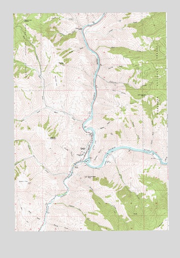
Riggins, ID USGS Topographic Map
Click on map above to begin viewing in our Map Viewer.

This topographic map contains these locations and features:
Feature Name Type Latitude Longitude GNIS ID View Map
AitkenLocaleN45.4077°W116.3257°394494View Map
Alum GulchValleyN45.3816°W116.3535°376585View Map
Bean CreekStreamN45.4641°W116.3535°377062View Map
Bean Creek SaddleGapN45.4963°W116.3665°377064View Map
Berg CreekStreamN45.4135°W116.2524°377387View Map
Captain John CreekStreamN45.3921°W116.3449°378900View Map
Chair CreekStreamN45.4777°W116.3107°379152View Map
Cherry CreekStreamN45.4702°W116.3060°379223View Map
Circle C RanchLocaleN45.4446°W116.3471°394507View Map
City of RigginsCivilN45.4204°W116.3179°2410949View Map
Clarks CreekStreamN45.4918°W116.3190°379376View Map
DogtownRidgeN45.3807°W116.2537°380696View Map
Dugout CreekStreamN45.4218°W116.2754°380925View Map
Egbert GulchValleyN45.4327°W116.3107°381272View Map
Emery CreekStreamN45.3818°W116.3501°381457View Map
Fiddle CreekStreamN45.4874°W116.3187°381678View Map
Fiddle Creek RapidsRapidsN45.4907°W116.3186°381679View Map
Flume GulchValleyN45.4132°W116.3262°381883View Map
Garrison FlatFlatN45.4613°W116.3412°382211View Map
Goat CreekStreamN45.4599°W116.2996°382312View Map
Hailey CreekStreamN45.4079°W116.3285°382803View Map
Hells Canyon Forest Service StationLocaleN45.4127°W116.3282°400568View Map
Idaho State Emergency Airstrip (historical)AirportN45.4241°W116.3093°394516View Map
Island BarBarN45.4171°W116.2599°394491View Map
Ladder CreekStreamN45.4888°W116.3204°384331View Map
Lightning CreekStreamN45.4646°W116.3085°384636View Map
Lightning Creek SaddleGapN45.4521°W116.2682°384639View Map
Little Berg CreekStreamN45.4202°W116.2660°384738View Map
Little Salmon RiverStreamN45.4166°W116.3149°384935View Map
McCanen GulchValleyN45.4563°W116.3090°394506View Map
North RiggensLocaleN45.4304°W116.3082°394508View Map
North Riggins CemeteryCemeteryN45.4295°W116.3138°394505View Map
Papoose CreekStreamN45.4179°W116.3596°388159View Map
Preacher MountainSummitN45.4282°W116.3471°388854View Map
Race CreekStreamN45.4460°W116.3479°389011View Map
RigginsPopulated PlaceN45.4221°W116.3154°389360View Map
Riggins City Fire DepartmentBuildingN45.4223°W116.3144°2619011View Map
Riggins Elementary SchoolSchoolN45.4227°W116.3149°401132View Map
Riggins Flight Strip (historical)AirportN45.4241°W116.3101°399190View Map
Riggins Police DepartmentBuildingN45.4226°W116.3143°2722383View Map
Riggins Post OfficePost OfficeN45.4199°W116.3160°2766861View Map
Salmon PointSummitN45.4188°W116.3074°398087View Map
Salmon River Junior - Senior High SchoolSchoolN45.4186°W116.3195°400681View Map
Schoolmarm PeakSummitN45.4057°W116.3162°390029View Map
Shorts CreekStreamN45.4188°W116.2993°390368View Map
Soard FlatFlatN45.4027°W116.3679°390798View Map
South Fork Race CreekStreamN45.4460°W116.3479°390999View Map
Squaw CreekStreamN45.4071°W116.3307°391296View Map
Traps CreekStreamN45.4807°W116.3168°392365View Map
WaltersLocaleN45.4893°W116.3149°394502View Map
West Fork Race CreekStreamN45.4460°W116.3479°393175View Map
Whiskey ButteSummitN45.4704°W116.3343°393283View Map
Whiskey GulchValleyN45.4635°W116.3087°394503View Map
WicksLocaleN45.3918°W116.3424°394493View Map
WisdomLocaleN45.4118°W116.3507°394492View Map

Note: Coordinates in the location and feature list above are referenced to NAD83 datum.


Copyright (C) 2008-2025 Ryan Niemi / Sunset Dynamics ... All Rights Reserved