TopoQuest Logo
Do you find TopoQuest useful?
Help keep TopoQuest running and adding new maps/features by donating!
Bitcoin:  19c7KJd3qBynnjoSw5npx9KScwjBe4ifkT
Litecoin:  LXs6TkuXGGXo1vDsWCkWVdjQX94eUKd6ui
Home View Maps Find Maps Find Places Resources & Links


Big Pool, Maryland Topographic Map

USGS Map Title: Big Pool, MD
USGS Map MRC: 39078E1
DRG (GeoTIFF) Download: o39078e1.tif


Neighboring USGS Topographic Map Quads:


  Hancock, MD  
39078F2
 

  Cherry Run, WV  
39078F1
 

  Clear Spring, MD  
39077F8
 

  Stotlers Crossroads, WV  
39078E2
 

  Big Pool, MD  
39078E1
 

  Hedgesville, WV  
39077E8
 

  Glengary, WV  
39078D2
 

  Tablers Station, WV  
39078D1
 

  Martinsburg, WV  
39077D8


Map MRC Location:

N40°
W79°
N40°
W78°
H8 H7 H6 H5 H4 H3 H2 H1
G8 G7 G6 G5 G4 G3 G2 G1
F8 F7 F6 F5 F4 F3 F2 F1
E8 E7 E6 E5 E4 E3 E2 E1
D8 D7 D6 D5 D4 D3 D2 D1
C8 C7 C6 C5 C4 C3 C2 C1
B8 B7 B6 B5 B4 B3 B2 B1
A8 A7 A6 A5 A4 A3 A2 A1
N39°
W79°
N39°
W78°

Big Pool, MD USGS 1:24K Topographic Map Preview:
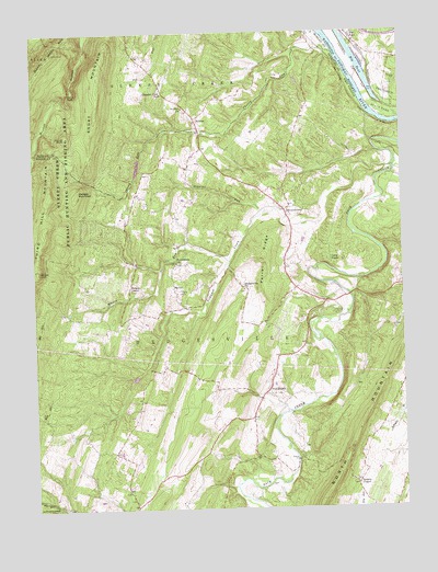
Big Pool, MD USGS Topographic Map
Click on map above to begin viewing in our Map Viewer.

This topographic map contains these locations and features:
Feature Name Type Latitude Longitude GNIS ID View Map
Allensville Memorial BridgeBridgeN39.5895°W78.0024°2635273View Map
BaxterPopulated PlaceN39.5576°W78.0775°1553812View Map
Big PoolLakeN39.6159°W78.0131°583229View Map
Big PoolPopulated PlaceN39.6237°W78.0158°589753View Map
Big Pool Post OfficePost OfficeN39.6240°W78.0160°1713571View Map
Boyd Rooney Farm SpringSpringN39.5293°W78.0600°1557744View Map
Brunswick Volunteer Ambulance Company Number 19BuildingN39.5261°W78.0600°2085754View Map
Butler Chapel CemeteryCemeteryN39.5068°W78.0167°1727405View Map
Butlers ChapelChurchN39.5065°W78.0161°1536803View Map
Camp FrameLocaleN39.5651°W78.0244°1536927View Map
Cannon HillSummitN39.5415°W78.0086°1727409View Map
Cherry RunStreamN39.6198°W78.0222°1537250View Map
Cherry Run Road BridgeBridgeN39.6170°W78.0450°2647535View Map
Devils NoseRidgeN39.6092°W78.1132°1538162View Map
Elk Branch (historical)Populated PlaceN39.5004°W78.1150°1727418View Map
Ferrell RidgeRidgeN39.5663°W78.0466°1538939View Map
Fort Frederick (historical)MilitaryN39.6103°W78.0036°1713889View Map
Fort Frederick State ParkParkN39.6101°W78.0033°584458View Map
Gough RunStreamN39.5934°W78.0078°1727434View Map
Hedges ChapelChurchN39.5576°W78.0917°1540120View Map
Hedges Chapel CemeteryCemeteryN39.5576°W78.0917°1727438View Map
Hedges MountainSummitN39.5829°W78.1097°1554675View Map
Hedgesville ChurchChurchN39.5579°W78.0536°1540122View Map
Hedgesville Fire Department SubstationBuildingN39.5922°W78.0778°2577820View Map
Hedgesville Post OfficePost OfficeN39.5578°W78.0013°1727445View Map
Higgins RunStreamN39.5782°W78.0472°1540242View Map
HoltonPopulated PlaceN39.6023°W78.0697°1554729View Map
JohnsontownPopulated PlaceN39.5784°W78.0394°1540993View Map
Johnsontown Brethren ChurchChurchN39.5793°W78.0361°1727451View Map
Johnsontown CemeteryCemeteryN39.5795°W78.0361°1727452View Map
Johnsontown SpringSpringN39.5745°W78.0411°1557769View Map
Johnsontown United Brethren Bible ChurchChurchN39.5776°W78.0375°1727454View Map
Locust Grove School (historical)SchoolN39.5151°W78.1047°1727467View Map
Mingo School (historical)SchoolN39.5640°W78.0903°1727475View Map
Paines KnobSummitN39.5981°W78.1131°1555294View Map
Parks GapGapN39.5132°W78.0197°1727497View Map
Parks Gap BridgeBridgeN39.5126°W78.0361°1940330View Map
Pittman CemeteryCemeteryN39.5576°W78.0536°1727500View Map
Pleasant View Elementary SchoolSchoolN39.6091°W78.0807°1545051View Map
Providence CemeteryCemeteryN39.5645°W78.0764°1727504View Map
Providence ChurchChurchN39.5648°W78.0767°1545301View Map
Riner CemeteryCemeteryN39.5034°W78.0931°1727508View Map
Runners Ferry (historical)CrossingN39.6190°W78.0208°1727510View Map
Short MountainSummitN39.6162°W78.1017°1555618View Map
Sleepy Hollow Lake DamDamN39.5884°W78.0881°1557377View Map
SnydersPopulated PlaceN39.6070°W78.0758°1557982View Map
Snyders CemeteryCemeteryN39.6048°W78.0733°1558032View Map
Snyders ChurchChurchN39.6051°W78.0739°1547049View Map
The Woods Resort Golf Course Mountain View CourseLocaleN39.5539°W78.1067°2634219View Map
The Woods Resort Golf Course Stony Lick CourseLocaleN39.5598°W78.0951°2634220View Map
Tilhance CreekStreamN39.5895°W78.0025°1548094View Map
TomahawkPopulated PlaceN39.5304°W78.0469°1555816View Map
Tomahawk CemeteryCemeteryN39.5301°W78.0436°1727528View Map
Tomahawk Intermediate SchoolSchoolN39.5539°W78.0209°1940331View Map
Tomahawk Presbyterian ChurchChurchN39.5301°W78.0442°1727530View Map
Tomahawk RunStreamN39.5254°W78.0389°1727531View Map
Tomahawk SpringSpringN39.5273°W78.0542°1557796View Map
Whites KnobSummitN39.5626°W78.1236°1555975View Map
Whites RunStreamN39.5648°W78.0589°1549099View Map

Note: Coordinates in the location and feature list above are referenced to NAD83 datum.


Copyright (C) 2008-2024 Ryan Niemi / Sunset Dynamics ... All Rights Reserved