TopoQuest Logo
Do you find TopoQuest useful?
Help keep TopoQuest running and adding new maps/features by donating!
Bitcoin:  19c7KJd3qBynnjoSw5npx9KScwjBe4ifkT
Litecoin:  LXs6TkuXGGXo1vDsWCkWVdjQX94eUKd6ui
Home View Maps Find Maps Find Places Resources & Links


Clear Spring, Maryland Topographic Map

USGS Map Title: Clear Spring, MD
USGS Map MRC: 39077F8
DRG (GeoTIFF) Download: o39077f8.tif


Neighboring USGS Topographic Map Quads:


  Big Cove Tannery, PA  
39078G1
 

  Mercersburg, PA  
39077G8
 

  Williamson, PA  
39077G7
 

  Cherry Run, WV  
39078F1
 

  Clear Spring, MD  
39077F8
 

  Mason and Dixon, PA  
39077F7
 

  Big Pool, MD  
39078E1
 

  Hedgesville, WV  
39077E8
 

  Williamsport, MD  
39077E7


Map MRC Location:

N40°
W78°
N40°
W77°
H8 H7 H6 H5 H4 H3 H2 H1
G8 G7 G6 G5 G4 G3 G2 G1
F8 F7 F6 F5 F4 F3 F2 F1
E8 E7 E6 E5 E4 E3 E2 E1
D8 D7 D6 D5 D4 D3 D2 D1
C8 C7 C6 C5 C4 C3 C2 C1
B8 B7 B6 B5 B4 B3 B2 B1
A8 A7 A6 A5 A4 A3 A2 A1
N39°
W78°
N39°
W77°

Clear Spring, MD USGS 1:24K Topographic Map Preview:
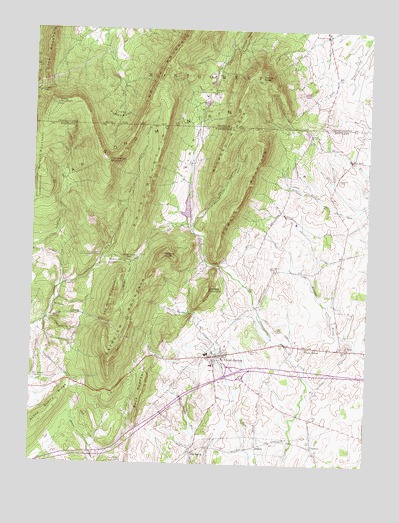
Clear Spring, MD USGS Topographic Map
Click on map above to begin viewing in our Map Viewer.

This topographic map contains these locations and features:
Feature Name Type Latitude Longitude GNIS ID View Map
Abe Mills MountainSummitN39.6701°W77.9700°582853View Map
AshtonPopulated PlaceN39.6301°W77.9150°589662View Map
Bear Pond HollowValleyN39.6893°W77.9699°583094View Map
Bear Pond MountainsRangeN39.7074°W77.9550°583095View Map
Big SpringSpringN39.6295°W77.9389°1713572View Map
Big SpringPopulated PlaceN39.6293°W77.9394°589756View Map
Big Spring Census Designated PlaceCensusN39.6259°W77.9396°2583584View Map
Blair ValleyBasinN39.7326°W77.9339°1169796View Map
Blairs Valley DamDamN39.6951°W77.9414°594330View Map
Blairs Valley LakeReservoirN39.6985°W77.9424°594331View Map
Boyd MountainSummitN39.6482°W77.9569°583346View Map
Bullskin MountainSummitN39.7084°W77.9972°583479View Map
CharltonPopulated PlaceN39.6301°W77.8942°589941View Map
Charlton Census Designated PlaceCensusN39.6344°W77.8944°2583597View Map
Clear SpringSpringN39.6554°W77.9300°1713584View Map
Clear SpringPopulated PlaceN39.6562°W77.9317°589986View Map
Clear Spring Ambulance Squad 49BuildingN39.6566°W77.9266°2639980View Map
Clear Spring Elementary SchoolSchoolN39.6568°W77.9338°1713585View Map
Clear Spring High SchoolSchoolN39.6576°W77.9369°1713586View Map
Clear Spring Middle SchoolSchoolN39.6583°W77.9361°1713587View Map
Clear Spring ParkParkN39.6545°W77.9342°1713588View Map
Clear Spring Post OfficePost OfficeN39.6551°W77.9289°1713589View Map
Clear Spring Station (historical)LocaleN39.6284°W77.9392°1713590View Map
Clear Spring Town HallBuildingN39.6568°W77.9292°1713591View Map
Clear Spring Volunteer Fire Company 4BuildingN39.6556°W77.9292°2087123View Map
Cross MountainSummitN39.7284°W77.9917°1172745View Map
Cushwa CemeteryCemeteryN39.7073°W77.8856°583998View Map
Cushwa MillLocaleN39.7079°W77.8875°1713598View Map
District 4, Clear SpringCivilN39.6692°W77.9220°1929608View Map
Dry RunPopulated PlaceN39.7129°W77.8811°588646View Map
Dunns GapGapN39.7326°W77.9972°1173628View Map
Fairview MountainSummitN39.6559°W77.9692°584334View Map
Fairview Outdoor Education CenterSchoolN39.6646°W77.9386°1713603View Map
Faith School (historical)SchoolN39.7129°W77.9022°1713605View Map
ForsythePopulated PlaceN39.6765°W77.9878°590220View Map
Gillians KnobSummitN39.6851°W77.9506°584590View Map
Green Spring CemeteryCemeteryN39.6254°W77.9667°584751View Map
Hanging RockPillarN39.6832°W77.9658°584855View Map
Hearthstone MountainSummitN39.7120°W77.9722°584918View Map
Hinkle RunStreamN39.6840°W77.9739°584988View Map
Indian SpringsSpringN39.6666°W77.9648°585140View Map
Indian Springs RunStreamN39.6668°W77.9939°585141View Map
Indian Springs Wildlife Demonstration AreaParkN39.7040°W77.9961°582837View Map
Interchange 18CrossingN39.6518°W77.9233°1713642View Map
Johns Hopkins University Geological Research StationSchoolN39.6848°W77.9775°582838View Map
Johnson MountainSummitN39.6751°W77.9344°590564View Map
Kasies KnobSummitN39.7356°W77.9147°1178244View Map
KasiesvillePopulated PlaceN39.7487°W77.8911°1192704View Map
Knob Hill WineryBuildingN39.7006°W77.8878°2704648View Map
Little Metropolitan CemeteryCemeteryN39.6523°W77.9314°1713649View Map
McLaughlin School (historical)SchoolN39.6848°W77.8847°1713662View Map
Oliver Co DamDamN39.7218°W77.8981°594536View Map
Polecat HollowValleyN39.6929°W77.9402°586629View Map
Powell MountainSummitN39.7059°W77.9197°586697View Map
Rickard MountainSummitN39.7256°W77.9214°586826View Map
Rose Hill CemeteryCemeteryN39.6576°W77.9178°586929View Map
Saint Andrews Episcopal ChurchChurchN39.6565°W77.9278°1713684View Map
Saint Clements ChapelChurchN39.6487°W77.9983°586994View Map
Saint Johns United Church of ChristChurchN39.6565°W77.9325°1713686View Map
Saint Michaels Catholic ChurchChurchN39.6545°W77.9317°1713687View Map
Saint Pauls CemeteryCemeteryN39.6598°W77.8817°1713690View Map
Saint Pauls ChurchChurchN39.6590°W77.8825°587134View Map
Saint Peters CemeteryCemeteryN39.6545°W77.9308°1713693View Map
Saint Peters Evangelical Lutheran ChurchChurchN39.6545°W77.9311°1713694View Map
Shady BowerPopulated PlaceN39.6590°W77.8969°587296View Map
Stone Cabin GapGapN39.6832°W77.9639°587570View Map
Stone Quarry RidgeRidgeN39.6368°W77.9968°587575View Map
Stoneleigh FarmLocaleN39.6333°W77.9433°2651731View Map
Sword MountainSummitN39.7112°W77.9544°587673View Map
The PunchbowlBasinN39.7268°W77.9681°1189446View Map
Town of Clear SpringCivilN39.6561°W77.9308°2390800View Map
Trinity Church of GodChurchN39.6554°W77.9300°1713708View Map
Two Top MountainSummitN39.7393°W77.9531°1193575View Map
Union Bethel CemeteryCemeteryN39.6898°W77.9381°1713711View Map
Union Bethel Church of GodChurchN39.6901°W77.9381°1713712View Map
Union ChurchChurchN39.7318°W77.9328°1190127View Map
Union SchoolSchoolN39.7495°W77.9714°1217458View Map
WCRH-FM (Williamsport)TowerN39.6595°W77.9653°598506View Map
WHAG-TV (Hagerstown)TowerN39.6598°W77.9656°598515View Map
WWPB-TV (Hagerstown)TowerN39.6512°W77.9706°598516View Map

Note: Coordinates in the location and feature list above are referenced to NAD83 datum.


Copyright (C) 2008-2024 Ryan Niemi / Sunset Dynamics ... All Rights Reserved