TopoQuest Logo
Do you find TopoQuest useful?
Help keep TopoQuest running and adding new maps/features by donating!
Bitcoin:  19c7KJd3qBynnjoSw5npx9KScwjBe4ifkT
Litecoin:  LXs6TkuXGGXo1vDsWCkWVdjQX94eUKd6ui
Home View Maps Find Maps Find Places Resources & Links


Riviera Beach, Texas Topographic Map

USGS Map Title: Riviera Beach, TX
USGS Map MRC: 27097C6
DRG (GeoTIFF) Download: o27097c6.tif


Neighboring USGS Topographic Map Quads:


  Ricardo, TX  
27097D7
 

  Riviera Beach NW, TX  
27097D6
 

  Riviera Beach NE, TX  
27097D5
 

  Riviera, TX  
27097C7
 

  Riviera Beach, TX  
27097C6
 

  Kleberg Point, TX  
27097C5
 

  Sarita, TX  
27097B7
 

  La Parra Ranch, TX  
27097B6
 

  La Parra Ranch NE, TX  
27097B5


Map MRC Location:

N28°
W98°
N28°
W97°
H8 H7 H6 H5 H4 H3 H2 H1
G8 G7 G6 G5 G4 G3 G2 G1
F8 F7 F6 F5 F4 F3 F2 F1
E8 E7 E6 E5 E4 E3 E2 E1
D8 D7 D6 D5 D4 D3 D2 D1
C8 C7 C6 C5 C4 C3 C2 C1
B8 B7 B6 B5 B4 B3 B2 B1
A8 A7 A6 A5 A4 A3 A2 A1
N27°
W98°
N27°
W97°

Riviera Beach, TX USGS 1:24K Topographic Map Preview:
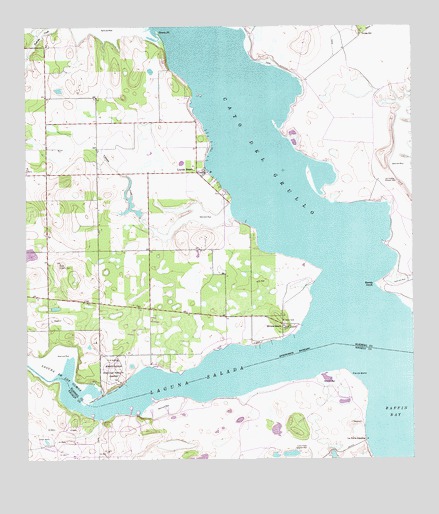
Riviera Beach, TX USGS Topographic Map
Click on map above to begin viewing in our Map Viewer.

This topographic map contains these locations and features:
Feature Name Type Latitude Longitude GNIS ID View Map
Araņa CreekStreamN27.3220°W97.6839°1372214View Map
Cayo del GrulloBayN27.3448°W97.6778°1372986View Map
Drum PointCapeN27.3728°W97.7067°1334630View Map
La Parra LandingPopulated PlaceN27.2553°W97.6405°1378543View Map
Laguna De Los OlmosBayN27.2762°W97.7386°1339459View Map
Laguna SaladaBayN27.2734°W97.6930°1339469View Map
Las Puertas Artesian WellWellN27.3306°W97.6347°1339685View Map
Lorna Prieta Artesian WellWellN27.2539°W97.6597°1340558View Map
Los Olmos CreekStreamN27.2659°W97.7286°1374731View Map
Loyola BeachPopulated PlaceN27.3337°W97.6947°1340705View Map
Neubauer PointCapeN27.3045°W97.6558°1377732View Map
Neubauer RockIslandN27.3034°W97.6458°1381040View Map
Neubauer RocksCliffN27.3012°W97.6492°1377713View Map
Pie de GalloCapeN27.2739°W97.6455°1343966View Map
Riviera BeachPopulated PlaceN27.2892°W97.6669°2033966View Map
Riviera BeachLocaleN27.2892°W97.6675°1345284View Map
Sandy HookCapeN27.3006°W97.6364°1346601View Map
VattmanPopulated PlaceN27.3331°W97.7453°2034929View Map
Visnaga WellWellN27.3731°W97.6417°1349310View Map

Note: Coordinates in the location and feature list above are referenced to NAD83 datum.


Copyright (C) 2008-2025 Ryan Niemi / Sunset Dynamics ... All Rights Reserved