TopoQuest Logo
Do you find TopoQuest useful?
Help keep TopoQuest running and adding new maps/features by donating!
Bitcoin:  19c7KJd3qBynnjoSw5npx9KScwjBe4ifkT
Litecoin:  LXs6TkuXGGXo1vDsWCkWVdjQX94eUKd6ui
Home View Maps Find Maps Find Places Resources & Links


Roche Harbor, Washington Topographic Map

USGS Map Title: Roche Harbor, WA
USGS Map MRC: 48123E2
DRG (GeoTIFF) Download: o48123e2.tif


Neighboring USGS Topographic Map Quads:


  Stuart Island, WA  
48123F2
 

  Waldron Island, WA  
48123F1


  Roche Harbor, WA  
48123E2
 

  Friday Harbor, WA  
48123E1


  False Bay, WA  
48123D1


Map MRC Location:

N49°
W124°
N49°
W123°
H8 H7 H6 H5 H4 H3 H2 H1
G8 G7 G6 G5 G4 G3 G2 G1
F8 F7 F6 F5 F4 F3 F2 F1
E8 E7 E6 E5 E4 E3 E2 E1
D8 D7 D6 D5 D4 D3 D2 D1
C8 C7 C6 C5 C4 C3 C2 C1
B8 B7 B6 B5 B4 B3 B2 B1
A8 A7 A6 A5 A4 A3 A2 A1
N48°
W124°
N48°
W123°

Roche Harbor, WA USGS 1:24K Topographic Map Preview:
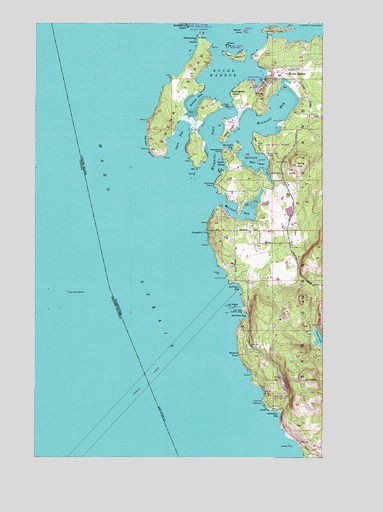
Roche Harbor, WA USGS Topographic Map
Click on map above to begin viewing in our Map Viewer.

This topographic map contains these locations and features:
Feature Name Type Latitude Longitude GNIS ID View Map
Afterglow Vista MausoleumCemeteryN48.6160°W123.1490°2608276View Map
Andrews BayBayN48.5487°W123.1621°1503034View Map
Barren IslandIslandN48.6229°W123.1605°1503188View Map
Battleship IslandIslandN48.6245°W123.1852°1503202View Map
Bazalgette PointCapeN48.6051°W123.1663°1503212View Map
Bell PointCapeN48.5926°W123.1566°1503286View Map
Bellevue PointCapeN48.5295°W123.1630°1503291View Map
Carefree LakeReservoirN48.5224°W123.1433°1532419View Map
Davison HeadCapeN48.6234°W123.1485°1504351View Map
Deadman BayBayN48.5123°W123.1452°1504366View Map
Delacombe PointCapeN48.5882°W123.1696°1504427View Map
English CampLocaleN48.5865°W123.1491°1513972View Map
Friday Harbor WatershedAreaN48.5337°W123.1288°1511765View Map
Garrison BayBayN48.5857°W123.1566°1505090View Map
Guss IslandIslandN48.5848°W123.1544°1505329View Map
Hanbury PointCapeN48.5787°W123.1732°1505365View Map
Henry IslandIslandN48.6040°W123.1882°1505470View Map
Horseshoe BayBayN48.5884°W123.1666°1505615View Map
Kellett BluffCliffN48.5884°W123.2019°1505926View Map
Lawson Dam Number TwoDamN48.5448°W123.1313°1532627View Map
Lime KilnLocaleN48.5157°W123.1527°1531661View Map
Lime Kiln LighthouseLocaleN48.5157°W123.1527°1506156View Map
Lime Kiln Point State ParkParkN48.5165°W123.1471°1534143View Map
Low IslandIslandN48.5434°W123.1646°1506348View Map
McCracken PointCapeN48.6209°W123.1805°1506547View Map
Mitchell BayBayN48.5693°W123.1624°1506742View Map
Mosquito BayBayN48.5743°W123.1735°1531691View Map
Mosquito PassChannelN48.5909°W123.1738°1506809View Map
Mount DallasSummitN48.5218°W123.1310°1512133View Map
Nelson BayBayN48.6004°W123.1832°1506951View Map
Open BayBayN48.5915°W123.1885°1507193View Map
Pearl IslandIslandN48.6154°W123.1652°1507348View Map
PoleIslandN48.6007°W123.1680°1507550View Map
Posey IslandIslandN48.6184°W123.1677°1510390View Map
Posey IslandIslandN48.6184°W123.1677°1507594View Map
Posey Island State ParkParkN48.6184°W123.1677°1513964View Map
Roache Habor Lake DamDamN48.5915°W123.1263°1532504View Map
Roche HarborPopulated PlaceN48.6098°W123.1488°1533054View Map
Roche HarborBayN48.6104°W123.1694°1507839View Map
Roche Harbor AirportAirportN48.6113°W123.1392°1533928View Map
Roche Harbor Resort MarinaLocaleN48.6099°W123.1543°2610380View Map
Roche Harbor Seaplane BaseAirportN48.6082°W123.1596°1533927View Map
Sams DamDamN48.5182°W123.1413°1532418View Map
San Juan Island Fire Department Roche Harbor Station 35BuildingN48.6119°W123.1475°2643650View Map
San Juan ParkParkN48.5429°W123.1607°1513950View Map
San Juan Park CampgroundLocaleN48.5425°W123.1596°2608264View Map
Seattle Yacht Club on Henry IslandLocaleN48.6034°W123.1726°2610387View Map
Smallpox BayBayN48.5412°W123.1599°1513952View Map
Smugglers CoveBayN48.5648°W123.1757°1508453View Map
Snug Harbor Marina ResortLocaleN48.5708°W123.1674°2610393View Map
Sunken RockIslandN48.5034°W123.1407°1514916View Map
Sunset PointCapeN48.5512°W123.1688°1514919View Map
Trout LakeReservoirN48.5326°W123.1266°1532190View Map
Westcott BayBayN48.5993°W123.1466°1514044View Map
White PointCapeN48.5940°W123.1671°1509474View Map
Yacht HavenPopulated PlaceN48.5851°W123.1682°1511441View Map
Young HillSummitN48.5840°W123.1377°1531920View Map

Note: Coordinates in the location and feature list above are referenced to NAD83 datum.


Copyright (C) 2008-2024 Ryan Niemi / Sunset Dynamics ... All Rights Reserved