TopoQuest Logo
Do you find TopoQuest useful?
Help keep TopoQuest running and adding new maps/features by donating!
Bitcoin:  19c7KJd3qBynnjoSw5npx9KScwjBe4ifkT
Litecoin:  LXs6TkuXGGXo1vDsWCkWVdjQX94eUKd6ui
Home View Maps Find Maps Find Places Resources & Links


Waldron Island, Washington Topographic Map

USGS Map Title: Waldron Island, WA
USGS Map MRC: 48123F1
DRG (GeoTIFF) Download: o48123f1.tif


Neighboring USGS Topographic Map Quads:


  Sucia Island, WA  
48122G8
 

  Stuart Island, WA  
48123F2
 

  Waldron Island, WA  
48123F1
 

  Eastsound, WA  
48122F8
 

  Roche Harbor, WA  
48123E2
 

  Friday Harbor, WA  
48123E1
 

  Shaw Island, WA  
48122E8


Map MRC Location:

N49°
W124°
N49°
W123°
H8 H7 H6 H5 H4 H3 H2 H1
G8 G7 G6 G5 G4 G3 G2 G1
F8 F7 F6 F5 F4 F3 F2 F1
E8 E7 E6 E5 E4 E3 E2 E1
D8 D7 D6 D5 D4 D3 D2 D1
C8 C7 C6 C5 C4 C3 C2 C1
B8 B7 B6 B5 B4 B3 B2 B1
A8 A7 A6 A5 A4 A3 A2 A1
N48°
W124°
N48°
W123°

Waldron Island, WA USGS 1:24K Topographic Map Preview:
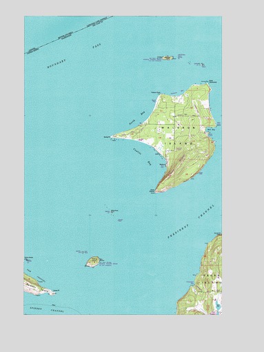
Waldron Island, WA USGS Topographic Map
Click on map above to begin viewing in our Map Viewer.

This topographic map contains these locations and features:
Feature Name Type Latitude Longitude GNIS ID View Map
Adolphus Island (historical)IslandN48.7312°W123.0216°1514768View Map
Bare IslandIslandN48.7293°W123.0146°1503163View Map
Boundary PassChannelN48.7401°W123.0763°1509727View Map
Cowlitz BayBayN48.6909°W123.0502°1504217View Map
Danger RockBarN48.6643°W123.0671°1531690View Map
Fishery PointCapeN48.7170°W123.0407°1504912View Map
Flattop IslandIslandN48.6470°W123.0830°1531454View Map
Gordon IslandIslandN48.7307°W123.0219°1514777View Map
Green PointCapeN48.6337°W123.1082°1505272View Map
Gull RockIslandN48.6509°W123.0896°1505326View Map
Lehman PondReservoirN48.6382°W123.0063°1532825View Map
Lehman Pond DamDamN48.6382°W123.0063°1532824View Map
Limberry PointCapeN48.7048°W123.0046°1531393View Map
Mail BayBayN48.7023°W123.0110°1506432View Map
Mouatt ReefBarN48.6848°W123.0441°1506814View Map
Mount CementSummitN48.6859°W123.0302°1531391View Map
North BayBayN48.7082°W123.0516°1507013View Map
Point DisneyCapeN48.6759°W123.0438°1507511View Map
Point HammondCapeN48.7201°W123.0091°1507520View Map
President ChannelChannelN48.6751°W123.0027°1507625View Map
San Juan County Fire District 2 / Orcas Island Fire and Rescue Station 24 Deer Harbor / Spring PointBuildingN48.6256°W123.0008°2643929View Map
Sandy PointCapeN48.6995°W123.0713°1508112View Map
Seversons BayBayN48.7195°W123.0285°1531392View Map
Skipjack IslandIslandN48.7323°W123.0374°1508312View Map
Skipjack IslandIslandN48.7318°W123.0360°1531835View Map
WaldronPopulated PlaceN48.6876°W123.0369°1511404View Map
Waldron IslandIslandN48.7003°W123.0288°1509259View Map
Waldron Island SchoolSchoolN48.7042°W123.0305°2518466View Map
Waldronaire AirportAirportN48.7118°W123.0182°1533742View Map
White RockIslandN48.6679°W123.0716°1509475View Map

Note: Coordinates in the location and feature list above are referenced to NAD83 datum.


Copyright (C) 2008-2024 Ryan Niemi / Sunset Dynamics ... All Rights Reserved