TopoQuest Logo
Do you find TopoQuest useful?
Help keep TopoQuest running and adding new maps/features by donating!
Bitcoin:  19c7KJd3qBynnjoSw5npx9KScwjBe4ifkT
Litecoin:  LXs6TkuXGGXo1vDsWCkWVdjQX94eUKd6ui
Home View Maps Find Maps Find Places Resources & Links


Rock Bluff, Florida Topographic Map

USGS Map Title: Rock Bluff, FL
USGS Map MRC: 30084E8
DRG (GeoTIFF) Download: o30084e8.tif


Neighboring USGS Topographic Map Quads:


  Cypress, FL  
30085F1
 

  Sneads, FL  
30084F8
 

  Chattahoochee, FL  
30084F7
 

  Altha East, FL  
30085E1
 

  Rock Bluff, FL  
30084E8
 

  Sycamore, FL  
30084E7
 

  Blountstown, FL  
30085D1
 

  Bristol, FL  
30084D8
 

  Hosford, FL  
30084D7


Map MRC Location:

N31°
W85°
N31°
W84°
H8 H7 H6 H5 H4 H3 H2 H1
G8 G7 G6 G5 G4 G3 G2 G1
F8 F7 F6 F5 F4 F3 F2 F1
E8 E7 E6 E5 E4 E3 E2 E1
D8 D7 D6 D5 D4 D3 D2 D1
C8 C7 C6 C5 C4 C3 C2 C1
B8 B7 B6 B5 B4 B3 B2 B1
A8 A7 A6 A5 A4 A3 A2 A1
N30°
W85°
N30°
W84°

Rock Bluff, FL USGS 1:24K Topographic Map Preview:
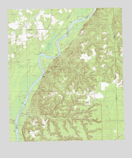
Rock Bluff, FL USGS Topographic Map
Click on map above to begin viewing in our Map Viewer.

This topographic map contains these locations and features:
Feature Name Type Latitude Longitude GNIS ID View Map
Able Airpark (historical)AirportN30.5955°W84.9810°309274View Map
Aspalaga LandingLocaleN30.6182°W84.9077°295097View Map
Big Sweetwater CreekStreamN30.5221°W84.9533°278761View Map
Blue SpringSpringN30.6177°W84.9199°279066View Map
Brown BranchStreamN30.5235°W84.9330°279467View Map
Ferrell BranchStreamN30.5224°W84.9358°282436View Map
Galilee ChurchChurchN30.5646°W84.9019°282882View Map
Graves CreekStreamN30.5196°W84.9933°283348View Map
Hickory HillSummitN30.6174°W84.9335°283960View Map
Hyhappo (historical)Populated PlaceN30.6169°W84.9916°294481View Map
Jenkins CreekStreamN30.5844°W84.9916°284745View Map
Johnson CreekStreamN30.5835°W84.9610°284870View Map
Long BranchStreamN30.5469°W84.9733°285959View Map
Ocheesee CreekStreamN30.5746°W84.9669°288044View Map
Ocheesee LandingPopulated PlaceN30.5821°W84.9660°294870View Map
Reds Fish CampLocaleN30.5177°W84.9955°304088View Map
Rock BluffPopulated PlaceN30.5435°W84.9127°294908View Map
Rock Bluff LandingLocaleN30.5608°W84.9633°295581View Map
Rock CreekStreamN30.5827°W84.9424°289813View Map
Rock of Will ChurchChurchN30.5691°W84.9046°289839View Map
Rockbluff Volunteer Fire DepartmentBuildingN30.5459°W84.9352°2644619View Map
Saint Rose ChurchChurchN30.6099°W84.9794°290388View Map
Saint Stephens ChurchChurchN30.5138°W84.9710°290390View Map
Short CreekStreamN30.5871°W84.9427°291083View Map
Spots BranchStreamN30.5196°W84.9210°291508View Map
Station BranchStreamN30.5902°W84.8802°291652View Map
SweetwaterPopulated PlaceN30.5080°W84.9721°295662View Map
Sweetwater CreekStreamN30.5258°W84.9880°291954View Map
Torreya State ParkParkN30.5691°W84.9477°292375View Map
Upper Sweetwater CreekStreamN30.5238°W84.9591°292714View Map

Note: Coordinates in the location and feature list above are referenced to NAD83 datum.


Copyright (C) 2008-2025 Ryan Niemi / Sunset Dynamics ... All Rights Reserved